Žacléř
Žacléř | |
|---|---|
Town | |
 Town hall | |
 Flag  Coat of arms | |
 Žacléř Location in the Czech Republic | |
| Coordinates: 50°39′49″N 15°54′41″E / 50.66361°N 15.91139°ECoordinates: 50°39′49″N 15°54′41″E / 50.66361°N 15.91139°E | |
| Country | |
| Region | Hradec Králové |
| District | Trutnov |
| First mentioned | 1334 |
| Government | |
| • Mayor | Aleš Vaníček |
| Area | |
| • Total | 21.82 km2 (8.42 sq mi) |
| Elevation | 612 m (2,008 ft) |
| Population (2020-01-01[1]) | |
| • Total | 3,136 |
| • Density | 140/km2 (370/sq mi) |
| Time zone | UTC+1 (CET) |
| • Summer (DST) | UTC+2 (CEST) |
| Postal code | 542 01 |
| Website | www |

Žacléř (Czech pronunciation: [ˈʒatslɛːr̝̊]) (German: Schatzlar) is a town in the Hradec Králové Region of the Czech Republic. It has around 3,100 inhabitants. The centre of the town is historically significant and is protected by law as Urban monument zone.
Administrative parts[]
Villages Bobr and Prkenný Důl are administrative parts of Žacléř.
Economy[]
Until 1992, hard coal was mined here.
Twin towns – sister cities[]
Žacléř is twinned with:
 Goldkronach, Germany[2]
 Kowary, Poland[3]
- Lubawka, Poland[4]
- Lwówek Śląski County, Poland[5]
Gallery[]
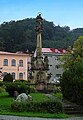
Marian column
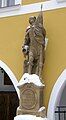
Sculpture of Saint Florian

Church of Holy Trinity

Panorama of Žacléř
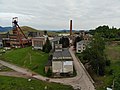
Jan Šverma Mine
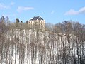
Žacléř Castle


References[]
- ^ "Population of Municipalities – 1 January 2020". Czech Statistical Office. 2020-04-30.
- ^ "Žacléřský zpravodaj č.8/2019" (PDF). zacler.cz (in Czech). Město Žacléř. August 2019. p. 2. Retrieved 2020-09-03.
- ^ "Raport o stanie miasta Kowary". bip.kowary.pl (in Polish). Biuletyn Informacji Publicznej Miasta Kowary. 2018. p. 128. Retrieved 2020-09-03.
- ^ "Main Page". um.lubawka.eu (in Polish). Gmina Lubawka. Retrieved 2020-09-03.
- ^ "Miasto Žacléř". powiatlwowecki.pl (in Polish). Lwówek Śląski County. Retrieved 2020-09-03.
External links[]
- Official website (in Czech)
 Media related to Žacléř at Wikimedia Commons
| show Authority control |
|---|
This Hradec Králové Region location article is a stub. You can help Wikipedia by . |
Categories:
- Populated places in Trutnov District
- Cities and towns in the Czech Republic
- Hradec Králové Region geography stubs