Sun Prairie, Wisconsin
City of Sun Prairie | |
|---|---|
City | |
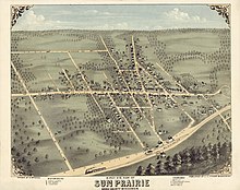
 Downtown Sun Prairie | |
|
Logo | |
| Nickname(s): Groundhog Capital of the World | |
 Location of Sun Prairie in Dane County, Wisconsin. | |
| Coordinates: 43°11′0.97″N 89°13′56.41″W / 43.1836028°N 89.2323361°W | |
| Country | |
| State | Wisconsin |
| County | Dane |
| Settled | 1839 |
| Incorporated (city) | 1958 |
| Government | |
| • Type | Mayor-city council |
| • Mayor | Paul Esser |
| • City Council president | Mary Polenske |
| • City Council members | show
Alderpersons |
| Area | |
| • Total | 12.93 sq mi (33.49 km2) |
| • Land | 12.91 sq mi (33.44 km2) |
| • Water | 0.02 sq mi (0.06 km2) |
| Elevation | 984 ft (300 m) |
| Population | |
| • Total | 35,967 |
| • Density | 2,685.03/sq mi (1,036.67/km2) |
| Time zone | UTC-6 (Central Standard Time) |
| • Summer (DST) | UTC-5 (Central Daylight Time) |
| ZIP code | 53590 |
| Area code(s) | 608 |
| FIPS code | 55-78600[6] |
| GNIS feature ID | 1584255[7] |
| Website | cityofsunprairie |

Sun Prairie is a city in Dane County in the U.S. state of Wisconsin. A suburb of Madison, it is part of the Madison Metropolitan Statistical Area. The city's population was 35,967 at the 2020 U.S. Census. It is the second-most populous city in Dane County after Madison.[9]
History[]
President Martin Van Buren commissioned a party of 45 men, including Augustus A. Bird, to build a capitol for the Territory of Wisconsin in Madison. The group left Milwaukee on May 26, 1837, and traveled for days in the rain. On June 9, the group emerged at the edge of the prairie and with the sun shining for the first time in days, carved the words "Sun Prairie" into a tree. Charles Bird returned to the area two years later and became the first settler.[10][11]
The Town of Sun Prairie was created on February 2, 1846.[12] The village of Sun Prairie, which grew from that town, was incorporated in an act of the Wisconsin legislature on March 6, 1868.[13]
On March 17, 1958, the Village Board ordered a referendum election on whether Sun Prairie should incorporate as a city of the fourth class after receiving a petition signed by over 100 electors. In the referendum election on May 6, 1958, 295 voted for incorporating as a city and 284 voted against. On May 15, 1958, the Wisconsin Secretary of State filed the certificate of incorporation of the city of Sun Prairie.[14]
On July 10, 2018, a gas explosion leveled a downtown city block, destroying a bar and a pizza restaurant, as well as damaging the historic old city hall building and multiple other nearby buildings. Bar owner and Fire Captain Cory Barr was injured in the explosion and died as a result soon after. Many citizens and businesses around Sun Prairie offered their support to the Barr family and the affected businesses through fundraising campaigns. This tragic event was the origin of the tagline "Sun Prairie Strong", a slogan which signifies the city's strength as it comes together as a community.[15]
Geography[]
According to the United States Census Bureau, the city has a total area of 12.25 square miles (31.73 km2), of which, 12.23 square miles (31.68 km2) is land and 0.02 square miles (0.05 km2) is water.[16] The city of Sun Prairie includes land that once was part of the towns of Bristol, Burke, Sun Prairie, and Windsor. On January 5, 2007, the city of Sun Prairie, city of Madison, village of DeForest, and town of Burke entered into a cooperative plan under which all remaining land in the town of Burke has been designated for attachment into the cities and village.[17]/>
Geology[]
The Yahara River Valley encompasses part of the city of Sun Prairie. This area contains deep glacial deposits created by the Wisconsin Glaciation. The eastern part of Dane County, known as the drumlin and marsh physiographic area, includes most of Sun Prairie. The deposits found in this area include general glacial deposits and marsh deposits, and consist of many small drumlins interspersed with shallow glacial deposits having poorly defined drainage.
The general soils associations in the Sun Prairie area include the Dodge-St. Charles-McHenry, Plano-Ringwood-Griswold, and Batavia-Houghton-Dresden Associations.[18] The Dodge-St. Charles-McHenry soils are found in the eastern, southern, and central portions of Sun Prairie. This association has a varied landscape, which is mostly sloping, with some areas on benches and in depressions. The Dodge, St. Charles and McHenry soils are well drained to moderately well drained. The Sable soils in this association are nearly level and poorly drained. Most of the soils in this association have moderate permeability and a high available water capacity. Most also have slight to moderate limitations for urban uses and farming.[19]
Cityscape[]

The landscape of the city consists mostly of gently rolling hills and plains. The elevation of the city averages about 984 feet (300 m) above mean sea level.[4]
Sun Prairie has developed a number of traditional neighborhood developments (TND).[20] Often referred to as "new urbanism", these neighborhoods focus on the pedestrian and the appearance of city streets. While these developments have sought to address the problems and concerns associated with conventional suburban development and urban sprawl, many occupy former farmland and undeveloped rural lands. The city's planners addressed the criticisms that they were "attempting to recreate "pretend" neighborhoods"[20] by noting that the aim of the TND was to borrow those design ideas and features effective in older neighborhoods and adapting them to current needs.[21]
Climate[]
| Sun Prairie | ||||||||||||||||||||||||||||||||||||||||||||||||||||||||||||
|---|---|---|---|---|---|---|---|---|---|---|---|---|---|---|---|---|---|---|---|---|---|---|---|---|---|---|---|---|---|---|---|---|---|---|---|---|---|---|---|---|---|---|---|---|---|---|---|---|---|---|---|---|---|---|---|---|---|---|---|---|
| Climate chart (explanation) | ||||||||||||||||||||||||||||||||||||||||||||||||||||||||||||
| ||||||||||||||||||||||||||||||||||||||||||||||||||||||||||||
| ||||||||||||||||||||||||||||||||||||||||||||||||||||||||||||
In the Köppen climate classification, Sun Prairie is in the warm summer humid continental climate zone (Dfa). Summers tend to be hot and humid. The warmest month of the year is July, with an average maximum temperature of 82.1 °F (27.8 °C) and the coldest month of the year is January, with an average minimum temperature of 9.3 °F (−12.6 °C). Temperature variations between night and day tend to be moderate during summer with an average difference of 21 °F (12 °C), and fairly limited during winter with an average difference of 16 °F (9 °C).
The annual average precipitation at Sun Prairie is 32.95 inches (837 mm). Rainfall is fairly evenly distributed throughout the year, and the wettest month of the year is August with an average rainfall of 4.33 inches (110 mm).
Flooding[]
The city of Sun Prairie encounters occasional flooding because of the presence of hydric soils, spring melting and its proximity to the Koshkonong Creek. This condition is compounded by storm water runoff from development and urbanization in the upper reaches of the watershed. Many residents of the city believe that the problems with flooding are worsening, becoming more frequent over the last 14 years.[23]
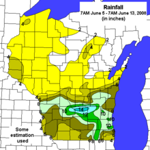
A flood on April 11, 2008, caused by heavy overnight rains that outpaced the city's storm drain system and leaked into the sewer system, resulted in flooding in residential basements.[24] The city suffered considerably from the June 2008 Midwest floods.
Demographics[]
| Historical population | |||
|---|---|---|---|
| Census | Pop. | %± | |
| 1870 | 626 | — | |
| 1880 | 597 | −4.6% | |
| 1890 | 704 | 17.9% | |
| 1900 | 938 | 33.2% | |
| 1910 | 1,119 | 19.3% | |
| 1920 | 1,236 | 10.5% | |
| 1930 | 1,337 | 8.2% | |
| 1940 | 1,625 | 21.5% | |
| 1950 | 2,263 | 39.3% | |
| 1960 | 4,008 | 77.1% | |
| 1970 | 9,935 | 147.9% | |
| 1980 | 12,931 | 30.2% | |
| 1990 | 15,333 | 18.6% | |
| 2000 | 20,369 | 32.8% | |
| 2010 | 29,364 | 44.2% | |
| 2020 (est.) | 35,119 | [25] | 19.6% |
| U.S. Decennial Census[26] | |||
2010 census[]
As of the census[5] of 2010, there were 29,364 people, 11,636 households, and 7,641 families residing in the city. The population density was 2,401.0 inhabitants per square mile (927.0/km2). There were 12,413 housing units at an average density of 1,015.0 per square mile (391.9/km2). The racial makeup of the city was 85.4% White, 6.1% African American, 0.3% Native American, 3.7% Asian, 1.4% from other races, and 3.0% from two or more races. Hispanic or Latino of any race were 4.3% of the population.

There were 11,636 households, of which 37.7% had children under the age of 18 living with them, 50.1% were married couples living together, 11.5% had a female householder with no husband present, 4.1% had a male householder with no wife present, and 34.3% were non-families. 26.1% of all households were made up of individuals, and 7.6% had someone living alone who was 65 years of age or older. The average household size was 2.51 and the average family size was 3.08.
The median age in the city was 33.3 years. 27.9% of residents were under the age of 18; 7.5% were between the ages of 18 and 24; 32.8% were from 25 to 44; 22.9% were from 45 to 64; and 8.9% were 65 years of age or older. The gender makeup of the city was 48.5% male and 51.5% female.
2000 census[]
As of the census[6] of 2000, there were 20,369 people, 7,881 households, and 5,437 families residing in the city. The population density was 2,133.7 people per square mile (823.5/km2). There were 8,198 housing units at an average density of 858.8 per square mile (331.4/km2). The racial makeup of the city was 92.68% White, 3.10% Black or African American, 0.29% Native American, 1.34% Asian, 0.03% Pacific Islander, 0.98% from other races, and 1.58% from two or more races. 2.72% of the population were Hispanic or Latino of any race.
There were 7,881 households, out of which 38.3% had children under the age of 18 living with them, 54.6% were married couples living together, 10.7% had a female householder with no husband present, and 31.0% were non-families. 23.8% of all households were made up of individuals, and 7.4% had someone living alone who was 65 years of age or older. The average household size was 2.56 and the average family size was 3.07.
In the city, the population was spread out, with 28.5% under the age of 18, 8.6% from 18 to 24, 33.7% from 25 to 44, 19.8% from 45 to 64, and 9.3% who were 65 years of age or older. The median age was 33 years. For every 100 females, there were 92.8 males. For every 100 females age 18 and over, there were 89.0 males.
The median income for a household in the city was $51,345, and the median income for a family was $61,197. Males had a median income of $40,510 versus $28,786 for females. The per capita income for the city was $23,277. About 3.8% of families and 4.4% of the population were below the poverty line, including 6.1% of those under age 18 and 5.3% of those age 65 or over.
Law and government[]
Sun Prairie has a mayor–council form of government. The mayor is elected at large every odd-numbered year. Paul Esser was elected mayor on April 7, 2015, when he defeated challenger Bill Clausius.[27]
The city council consists of eight alderpersons, who along with the mayor, make up the common council. There are four aldermanic districts, with two alderpersons per district, each serving for two-year terms over alternating years. The council manages the city's budget and financial operations as well as determines the salaries of all officers and employees of the city.
Sun Prairie has a full-time city administrator, who is responsible for the administration of the city government in accordance with the policies established by the common council. Other city officers consist of assistant administrator, city clerk, treasurer, assessor, municipal judge, police chief and fire chief.
Representative Gary Hebl and Senator Melissa Agard represent the city of Sun Prairie in the Wisconsin State Legislature. At the federal level, the city is represented by Ron Johnson (R) and Tammy Baldwin (D) in the U.S. Senate and Mark Pocan (D) in the House of Representatives.
Mayors[]
| Mayor | Tenure |
|---|---|
| Joe Hanley | 1958–1960 |
| Anton J. Thomas | 1961–1964 |
| Clarence Severson | 1965–1968 |
| Theodore W. Chase | 1969–1973 |
| Robert Schaben | 1974–1980 |
| Donald Foulke | 1981–1987 |
| Paul Esser | 1987–1990 |
| JoAnn Orfan | 1990–2003 |
| Dave Hanneman | 2003–2005 |
| Joe Chase | 2005–2011 |
| John Murray | 2011–2014 |
| Jonathan Freund | 2014–2015 |
| Paul Esser | 2015– |
| Wisconsin gubernatorial election in Sun Prairie, Wisconsin, 2018 [28] | ||||||
|---|---|---|---|---|---|---|
| Party | Candidate | Votes | Percentage | |||
| Democratic | Tony Evers | 10,331 | 67.88% | |||
| Republican | Scott Walker | 4,583 | 30.11% | |||
| Others | 305 | 2.00% | ||||
| United States Senate election in Sun Prairie, Wisconsin, 2018 [28] | ||||||
|---|---|---|---|---|---|---|
| Party | Candidate | Votes | Percentage | |||
| Democratic | Tammy Baldwin | 10,798 | 71.16% | |||
| Republican | Leah Vukmir | 4,348 | 28.65% | |||
| Others | 28 | 0.19% | ||||
Media[]
Sun Prairie has had two local public-access television cable TV stations, KSUN-12 and KIDS-4, for over 30 years.[29] KIDS-4's programming content, camera, sound, lighting, editing, writing, and direction are produced by 30 to 40 children selected each year.[30][31] Historically, these children have ranged in age from nine to fourteen,[32] but in 2000, the first high school-aged crew was introduced.[31]
In July 2015, WLSP-LP (103.5) came to the air as a community radio station.[33][34]
The city is served by two local newspapers: the Sun Prairie Star (formerly the Star Countryman), and the Hometown Advertiser. Also available is the Wisconsin State Journal, a Madison regional newspaper.
Radio and television is available over the air and on cable/satellite from Madison.
Public services[]
Fire department[]
Sun Prairie has a combination fire department that serves both the city and town of Sun Prairie, as well as the towns of Burke and Bristol.[35] The department, which began in 1891, consists of 45 members who maintain external jobs, 14 career staff and 8 LTE[clarification needed] positions. The fire department has 10 fire engines and two vintage vehicles, a 1927 Stoughton fire engine refurbished by a past fire department chief and a second 1927 Stoughton fire engine that was Sun Prairie's first motorized fire truck. This was refurbished at the direction of Captain Cory Barr, who later was killed in the 2018 Sun Prairie Explosion where his bar, The Barr House, exploded. Both are used solely for parades.[36]
In 2002 and 2003, the SPFD received $235,575 in federal funding from the U.S. Department of Homeland Security (DHS),[37] and in 2004 and 2005 received $396,950.[38] In 2006 and 2007, the amount of assistance was $79,519.[39]
Emergency medical services[]
Sun Prairie maintains its own emergency medical service, which is a charter member of Dane County's Mutual Aid Box Alarm System (MABAS). Responding to over 3,200 calls in 2020, the department addresses medical and rescue calls in the city of Sun Prairie and the Town of Bristol in a district covering 50 square miles (130 km2) with a population of nearly 40,000.
The EMS was founded in October 1977 as an extension of the local police department. The city's rapid growth affected ambulance response times negatively, and the 1980s saw the hiring of a full-time EMS director.[40] In the 1980s and 1990s, most of the service was slowly replaced by full-time EMTs. In the 1990s, the service made a transition from EMT-basic personnel to that of intravenous technician levels and paramedic level.[41]
Sun Prairie EMS transports to all Madison hospitals and to Columbus Community Hospital in Columbus. In 2009 St. Mary's Hospital of Madison opened a free-standing emergency room facility in Sun Prairie.[42]
Utilities[]
The city owns its own utilities, the Water & Light Commission and the Water Pollution Control Facility. Sun Prairie's water is supplied from six wells pumped into the system or stored in the three water towers, which maintain a storage capacity of 2.85 million US gallons (10,800 m3). The bulk of the city's electricity is purchased or generated by Sun Prairie Water & Light, a Wisconsin Public Power, Inc (WPPI) member utility.[43] Natural gas is supplied to the city by WE-Energies with headquarters in Milwaukee, Wisconsin.
Telecommunications[]
Telephone and Internet services are provided by Frontier Communications, TDS Telecom,and Charter Communications.
Sun Prairie Public Library[]
The Sun Prairie Public Library's service area includes the city of Sun Prairie, the Town of Sun Prairie, the Town of Bristol, and other area communities. It is part of the South Central Library System. Services include youth programming, adult programming, reference, database, technical services, and circulation.
Sun Prairie Family Aquatic Center[]
The Sun Prairie Family Aquatic Center (FAC) is a municipal swimming pool that serves the Sun Prairie area. Opened on May 30, 1992, it replaced the previous municipal pool that opened in 1958 in Angell Park. The Family Aquatic Center has an 18-foot drop slide, two diving boards, eight competition lanes, and a 210-foot water slide. There are play structures and sand volleyball courts inside the pool compound. The Sun Prairie Piranhas, the city's youth swim team, practice at the Family Aquatic Center. They are a member of the Tri-County Swimming Conference.[44][45]
Economy[]
QBE Insurance has American operations in Sun Prairie. Other significant employers include the Sun Prairie School District, American Family Insurance, Colony Brands, and Frontier Communications. Many residents commute to jobs in Madison.
Education[]
The Sun Prairie Area School District administers local public education. The system, which as of the 2007–08 school year enrolled 6,024 students, consists of nine elementary schools, two middle schools, an upper-middle school and a single high school.[46]
There are two parochial schools in Sun Prairie. Founded in 1892, Sacred Hearts School is a Catholic school serving children of pre-kindergarten through 8th grade.[47] Peace Evangelical Lutheran School is a pre-K through 8th grade school of the Wisconsin Evangelical Lutheran Synod.[48] Calvary Baptist, which had an enrollment of 25 students, closed effective June 30, 2008.[49]
Recreation[]
Points of interest[]
Sun Prairie Water Tower | |
U.S. National Register of Historic Places | |
 The Columbus Street Water Tower | |
 | |
| Location | Sun Prairie, Wisconsin |
|---|---|
| Coordinates | 43°11′14″N 89°12′39″W / 43.18722°N 89.21083°WCoordinates: 43°11′14″N 89°12′39″W / 43.18722°N 89.21083°W |
| Built | 1899 |
| Architect | Stegerwald, Frank |
| NRHP reference No. | 00000360[50] |
| Added to NRHP | April 6, 2000 |
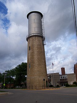
Four properties in Sun Prairie are listed in the National Register of Historic Places: the Dr. Charles G. Crosse House, the Fuhremann Canning Company Factory, the Adam and Mary Smith House, and the Sun Prairie Water Tower. The Crosse House was built in 1864 by a locally prominent physician and city leader. The Fuhremann Canning Company Factory, in use from 1900 to 1974, now lies vacant.[51] The Adam and Mary Smith House was constructed in 1879 by Adam Smith, who had come to Wisconsin to do shingle work on the Wisconsin State Capitol. The Sun Prairie Water Tower, located at the junction of Columbus, Church and Cliff Streets, was designed by Frank Stegerwald and constructed in 1912 of stone, metal, and wood.[52]
Other points of interest include:
- The National Midget Auto Racing Hall of Fame at Angell Park Speedway
- The Youth Baseball Complex, home to baseball and softball programs, including Sun Prairie's Little League program
- Sun Prairie Historical Library and Museum
- The Sun Prairie Firemans Park in the Prairie, a community-built park completed in 2007
- The Prairie Athletic Club has a water park called Dolphins Cove
- Sun Prairie Golf Course
- Sun Prairie Family Aquatic Center

Transportation[]
"1990 Census data indicates that most Sun Prairie residents drive their own vehicles to work (79.4%). A fair number of residents use carpooling as their primary transportation to work (13.4%). Other methods of transportation remain a minor factor."[53]
Interstate highways[]
 I-39 runs concurrently with I-90 from Illinois to Portage. In Madison, they are joined by I-94 until Portage. This overlap occurs in the area immediately between the metropolitan city of Madison and Sun Prairie.
 I-90 runs east–west through the western, central and southern portions of the state, and is located to the west of Sun Prairie. A total of 187 miles (301 km) of Interstate 90 lie in Wisconsin;[54] the Madison exit (designated 135B) leads to US 151 North and Sun Prairie.
 I-94 as it occurs in Wisconsin runs east–west through the western, central and southeastern portions of the state. The junction of I-90 and i-94 occurs roughly six miles to the southwest of Sun Prairie heading eastward toward Milwaukee at what is commonly known as the "Badger Interchange" where the three interstates (I-39, I-90 and I-94) meet at the eastern terminus of WIS 30.[55]
U.S. routes[]
 U.S. Route 151 (normally called U.S. Highway 151, 151 or US-151) is a freeway in Sun Prairie that runs northeast–southwest across the eastern to southwest portions of the state. Sun Prairie is divided lengthwise by US-151, southwest to northeast, having four different access points: Windsor Street, Reiner Road/Grand Ave., Main Street and Bristol Street.
Wisconsin state routes[]
 Wisconsin Highway 19 (often called Highway 19, STH 19 or WIS 19) is a state highway which passes around the north side of Madison and crosses US-151 as it passes through Sun Prairie. It serves as a local connector route that links via various interchanges the communities of Sun Prairie, Watertown and Waunakee. The roadway follows two-lane surface road for the entire length with the exception of urban multilane arterials.
Prior to 1947, WIS 19 followed the current route of US-18 between Bridgeport and Madison. The route then passed through downtown Madison and followed then WIS 31 (part of the current US-151) to Sun Prairie. East of Sun Prairie the route followed its present-day alignment to Watertown. The route then followed present-day WIS 16 to Waukesha and east from there along present-day WIS 59 into Milwaukee.[56] When the U.S. Highway system was implemented, WIS 19's western terminus was relocated to Madison. The portion between Madison and Sun Prairie remained despite the debut of US-151 as did the eastern portion that became concurrent with US-16. In 1947, the eastern terminus was moved to Watertown, the section along US-151 was removed, and the portion between Mazomanie and Sun Prairie was implemented.[57]
The part of WIS 19 roughly from those interstates west to WIS 113 had at one time been on the corridor of a planned beltline route around the north side of Madison. The current status of the parkway is uncertain.[58]
County routes[]
Sun Prairie is bordered by the following county roads:
- C (also named N. Grand Avenue) runs north–south and borders Sun Prairie to the west and is crossed by interchange by US-151.
- N (also named N. Bristol Street) runs north–south and bisects a third of the city to the west and is crossed by interchange by US-151.
- VV (also named Twin Lane Road) runs north–south and borders the city to the east and is crossed by interchange by US-151.
- Vinburn Road, which borders the city to the north, runs west toward DeForest and east toward Columbus.
Bus service[]
Sun Prairie has no municipal bus, but instead has provided a Shared Ride Taxi service[59] for the past decade, whereby residents can travel throughout the city for a small charge, sometimes sharing the ride with other passengers. This service is subsidized by grants obtained by the city, which also provide for low income transit via the use of identification cards. Corner service is also available at some street locations during the academic school year, and is intended primarily for middle-school and high school students. Although the taxi service is exclusively for the city, Shared Taxi also provides for thrice-daily shuttle service (8:30 am, 12:30pm, 4:30pm) to nearby East Towne Mall, on the northeastern edge of Madison, where commuters can connect to the Madison Metro bus system.
As of August 2019, Madison Metro Route 23 has peak-hour service to and from Sun Prairie as part of regional commuter service.
Airports[]
Dane County Regional Airport (IATA: MSN, ICAO: KMSN, FAA LID: MSN), also known as MSN Truax Field, is a commercial airport located 10 miles (16 km) southwest of Sun Prairie.[46] Dane County Regional Airport has three runways and in 2006 served over 1.6 million passengers.[60] Airlines serving the airport include AmericanConnection, American Eagle, Delta, Delta Connection, Frontier Airlines, United, United Express, and Sun Country Airlines.
Railroads[]
Although Sun Prairie has tracks for freight trains to the south of the city, the only passenger train to serve the area is Amtrak's Empire Builder, which operates in the Midwestern and Northwestern United States. The route runs from Chicago to the Pacific Northwest, arriving in nearby Columbus (CBS). The ridership on the train has increased slowly, averaging 16,850 per year traveling to and from Columbus,[61] despite the population growth in Sun Prairie. Travel time to and from Chicago is slightly under three hours.[62]
Local events[]
Sun Prairie's Jimmy the Groundhog is the local favorite on Groundhog Day in February.[63] The United States Congressional Record described the city as the "Groundhog Capital of the World" in 1955.[64] During the city's Groundhog Day celebration on February 2, 2015, Jimmy bit Mayor Jonathan Freund's ear.[65] The next day, Freund issued a proclamation that pardoned and absolved Jimmy "of any perceived wrongdoing and charges" under the city's ordinances.[66] Two weeks later, Freund came in last of three candidates in the city's mayoral primary election.[67] Following the biting incident, the United States Department of Agriculture and the Wisconsin Department of Natural Resources declared that capturing wild animals for exhibit was against the law.[68][69] Sun Prairie's next Groundhog Day celebration on February 2, 2016, featured a caged groundhog purchased for $1,200.[69][70]
In mid-June, the city holds a local Taste of the Arts fair, in conjunction with the Georgia O'Keeffe Celebration.[71] Artwork is exhibited and instructional classes for arts and crafts are held. A Georgia O'Keeffe recreation discussion is held.[71]
The Flags of Freedom Field Show is a day-long series of events in July, involving high-school marching band competitions with bands from throughout the United States and Canada. It is hosted by the Sound of Sun Prairie.[72]
In mid-August of each year, Sun Prairie hosts a Sweet Corn Festival. Over 70 short tons of sweet corn are served or sold during the weekend event, which includes a carnival, a parade down Main Street and performances by local and regional musical groups.[73]
Notable people[]
- Jerome L. Blaska, Wisconsin state representative
- Will Butcher, 2017 Hobey Baker Award winner[74]
- Willard H. Chandler, Wisconsin state senator
- Charles G. Crosse, physician and politician
- Paige Davis, actress best known as a host of reality television series Trading Spaces
- Nathan Haseleu, NASCAR driver[75]
- Gary Hebl, Wisconsin state representative
- Robert Kastenmeier, congressman who lived in Sun Prairie while in office[76]
- Todd Kluever, former NASCAR driver and 2005 NASCAR Craftsman Truck Series Rookie of the Year
- John A. List, University of Chicago economist, pioneer in charity research
- Georgia O'Keeffe, artist, winner of Presidential Medal of Freedom and National Medal of Arts[77]
- Irvin E. Rockwell, Idaho state senator
- Ellen Clara Sabin, educator
- Casey Scheuerell, musician
- Andy Thompson, former MLB player for the Toronto Blue Jays
References[]
- ^ "City of Sun Prairie - Mayor Home". City of Sun Prairie. Archived from the original on 2012-03-01. Retrieved 2007-09-05.
- ^ "City of Sun Prairie - City Council Home". City of Sun Prairie. Archived from the original on 2007-09-28. Retrieved 2007-09-05.
- ^ "2019 U.S. Gazetteer Files". United States Census Bureau. Retrieved August 7, 2020.
- ^ Jump up to: a b "Geographic Names Information System Feature Detail Report". United States Geological Survey. 1995-09-01. Retrieved 2007-09-05.
- ^ Jump up to: a b "U.S. Census website". United States Census Bureau. Retrieved 2012-11-18.
- ^ Jump up to: a b "U.S. Census website". United States Census Bureau. Retrieved 2008-01-31.
- ^ "Geographic Names Information System". United States Geological Survey. Retrieved 2008-01-31.
- ^ "Population and Housing Unit Estimates". United States Census Bureau. May 24, 2020. Retrieved May 27, 2020.
- ^ State of Wisconsin Blue Book 2007-2008 (PDF). Wisconsin State Legislature Legislative Reference Bureau. July 2007. p. 749. Archived from the original (PDF) on 2008-06-24. Retrieved 2008-07-25.
- ^ "Our Community: History". www.cityofsunprairie.com. City of Sun Prairie. Archived from the original on 2008-07-13. Retrieved 2008-07-25.
- ^ "Dictionary of Wisconsin History". www.wisconsinhistory.org. Wisconsin Historical Society. Retrieved July 25, 2008.
- ^ "Dictionary of Wisconsin History". www.wisconsinhistory.org. Wisconsin Historical Society. Retrieved 2008-07-25.
- ^ Private and Local Laws Passed by the Legislature of Wisconsin in the Year 1868, Volume 2, ch. 338.
- ^ "Articles of Incorporation, Wisconsin Secretary of State". May 15, 1958.
- ^ "Sun Prairie Stronger: Reflecting and remembering July 10 explosion".
- ^ "US Gazetteer files 2010". United States Census Bureau. Retrieved 2012-11-18.
- ^ (PDF) https://www.cityofmadison.com/planning/pdf/BurkeDe.pdf. Missing or empty
|title=(help) - ^ "Comprehensive Plan – 2003-2022: Agricultural, Natural and Cultural Resources Element". Town of Bristol. Archived from the original on September 23, 2006. Retrieved 2008-07-24.
- ^ "City of Sun Prairie Master Plan 2020" (PDF). www.cityofsunprairie.com. City of Sun Prairie. Retrieved 2008-07-24.
- ^ Jump up to: a b "Traditional Neighborhood Development in Sun Prairie (TND)". www.cityofsunprairie.com. City of Sun Prairie. Retrieved 2008-07-24.
- ^ "TND Design Principles" (PDF). www.cityofsunprairie.com. City of Sun Prairie. Retrieved 2008-07-24.
- ^ "Sun Prairie, Wisconsin, United States of America". www.weatherbase.com. Canty and Associates LLC. Retrieved 2008-07-25.
- ^ "Dane County Natural Hazard Mitigation Plan: Attachment 11: Town of Sun Prairie" (PDF). Dane County. September 30, 2004. p. 8.
- ^ Schultz, Zac (2008-04-11). "Weather Alert: Sun Prairie Flooding". NBC15.com. NBC15. Retrieved 2008-07-31.
- ^ "City and Town Population Totals: 2010-2020". Retrieved June 22, 2021.
- ^ "Census of Population and Housing". Census.gov. Retrieved June 4, 2015.
- ^ "Sun Prairie voters elect Esser over Clausius for mayor". 8 April 2015.
- ^ Jump up to: a b https://elections.wi.gov/elections-voting/results-all
- ^ "About". 11 September 2017.
- ^ "KIDS-4 Television". Sun Prairie Cable Access. Retrieved August 27, 2008.
- ^ Jump up to: a b "Sun Prairie Cable Access TeleVision FAQs". Sun Prairie Cable Access. Retrieved 2008-08-27.
- ^ "Kids 4 TV Show". Center for Study of Upper Midwestern Cultures. October 2, 2002. Archived from the original on August 29, 2006. Retrieved August 27, 2008.
- ^ http://www.sunprairiemediacenter.com/thesuncommunityradio
- ^ http://www.sunprairiemediacenter.com/about/community
- ^ http://www.cityofsunprairie.com/admin/images/6105a6e177.pdf
- ^ "City of Sun Prairie - Pumpers".
- ^ Jump up to: a b Government, Center For Effective. "Federal Assistance to Recipient ELIZABETH MANOR APT II (in VA, no D&B), FY 2000-2015, summary". www.fedspending.org.
- ^ Jump up to: a b Government, Center For Effective. "Federal Assistance to Recipient ELIZABETH MALLARD (in NJ, no D&B), FY 2000-2015, summary". www.fedspending.org.
- ^ Jump up to: a b "City of Sun Prairie - Fire Home".
- ^ "City of Sun Prairie - 1980's".
- ^ "City of Sun Prairie - 2000's".
- ^ "Emergency Care for Sun Prairie Closer to Home".
- ^ Sun Prairie Water & Light
- ^ "Family Aquatic Center - Sun Prairie, WI - Official Website". www.cityofsunprairie.com.
- ^ Michael Popke, Special to The Star. "Piranhas spearhead Sun Prairie's swimming growth".
- ^ Jump up to: a b "City of Sun Prairie - Our Community Home". Archived from the original on 2008-07-08. Retrieved 2008-07-08.
- ^ "Sacred Hearts School - Sun Prairie, Wisconsin". www.sacredhearts.k12.wi.us.
- ^ "Welcome to Peace School!".
- ^ "Calvary Baptist Christian School".
- ^ "National Register Information System". National Register of Historic Places. National Park Service. April 15, 2008.
- ^ http://www.nationalregisterofhistoricplaces.com/wi/Dane/vacant.html National Register of Historic Places - Dane County, Wisconsin
- ^ "Sun Prairie Water Tower - Archiplanet".
- ^ "June 4, 1999" (PDF).
- ^ U.S. Department of Transportation - Federal Highway Administration (2002-10-31). "Route Log: Main Routes of the Dwight D. Eisenhower National System Of Interstate and Defense Highways as of October 31, 2002". Retrieved 2006-08-28.
- ^ http://www.gov.state.ak.us/omb/02_OMB/Budget/Trans/proj34537.pdf
- ^ "Rand McNally Auto Road Atlas". Rand McNally. 1926. Retrieved 2008-01-02.
- ^ Bessert, Christopher J. "Wisconsin Highways: Highways 10-19". www.wisconsinhighways.org.
- ^ North Mendota Parkway Advisory Committee accessed 13 August 2006
- ^ "City of Sun Prairie - Taxi Service".
- ^ FAA Airport Form 5010 for MSN PDF, effective 2007-12-20
- ^ "Amtrak" (PDF).
- ^ "New Title" (PDF).
- ^ "Groundhog Day Sun Prairie". www.sun-prairie-wisconsin.com.
- ^ (1) "Punxsutawney Groundhog Day". Congressional Record, 84th Congress, First Session: House of Representatives. 101 (18). February 2, 1955. Archived from the original on March 12, 2007. Retrieved February 9, 2015.. In "Mr. Groundhog Goes to Washington ..." Groundhog Central. Archived from the original on October 16, 2008. Retrieved February 9, 2015. External link in
|work=(help)
(2) Congressional Record. 84th cong., 1st sess., 1955, 121, no.15, (2 February 1955) - ^ Ola, Mary Jo (February 2, 2015). "Jimmy the Groundhog's forecast debated; mayor bitten". Channel 3000.com. Madison, Wisconsin: WISC-TV. Retrieved February 3, 2015. External link in
|work=(help) - ^ Munos, Carlos (February 4, 2015). "Sun Prairie mayor pardons Jimmy the Groundhog". Fond du Lac, Wisconsin: fdlreporter.com. Archived from the original on April 17, 2019. Retrieved February 7, 2015. External link in
|publisher=(help) - ^ "Mayor Who Suffered Groundhog Bite Loses Primary". ABC News. Associated Press. February 18, 2015. Archived from the original on February 18, 2015. Retrieved February 19, 2015.
- ^ Tan, Avianne (June 9, 2015). "Jimmy the Groundhog Likely Out on Groundhog Day After Biting Wisconsin Mayor's Ear". ABC News. Archived from the original on June 10, 2015. Retrieved February 6, 2016.
- ^ Jump up to: a b Delong, Katie (January 28, 2016). "New plans for Groundhog Day in Sun Prairie this year, after "Jimmy" bit the mayor last year". Fox6Now.com. Archived from the original on February 4, 2016. Retrieved February 6, 2015.
- ^ Glaze, Jeff (February 3, 2016). "For some in Sun Prairie, caged Jimmy the Groundhog not the same". Wisconsin State Journal. Archived from the original on February 3, 2016. Retrieved February 6, 2016.
- ^ Jump up to: a b "Sun Prairie Chamber of Commerce : Taste of the Arts Fair/O'Keeffe Celebration".
- ^ "SOSP". Sun Prairie Band Boosters.
- ^ "Sun Prairie Chamber of Commerce : Sweet Corn Festival 2009". Archived from the original on 2014-08-13. Retrieved 2009-06-30.
- ^ Wilson, Jay (7 April 2017). "Sun Prairie's Butcher wins Hobey Baker".
- ^ http://haseleu.com/files/familymembers.aspx
- ^ Barone, Michael; and Ujifusa, Grant. The Almanac of American Politics 1988', p. 1295. National Journal, 1987.
- ^ "Georgia O'Keeffe Celebration". www.sun-prairie-wisconsin.com.
Further reading[]
- Reily, Nancy Hopkins (2007). Georgia O'Keeffe, A Private Friendship, Part 1: Walking the Sun Prairie Land. Santa Fe: Sunstone Press.
External links[]
| Wikimedia Commons has media related to Sun Prairie, Wisconsin. |
| show City of Madison and Metropolitan Area |
|---|

| show Municipalities and communities of Dane County, Wisconsin, United States |
|---|

| show |
|---|

| show Authority control |
|---|
- Cities in Wisconsin
- Cities in Dane County, Wisconsin
- Populated places established in 1839
- 1839 establishments in Wisconsin Territory