Swat River
| Swat River سوات | |
|---|---|
 | |
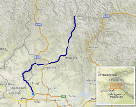 Course of the Swat (interactive map) | |
| Location | |
| Country | |
| province | Khyber Pakhtunkhwa |
| District | Swat |
| Physical characteristics | |
| Source | Hindu Kush Mountains |
| Source confluence | Usho and Gabral rivers |
| • location | Kalam |
| Mouth | Kabul River |
• location | Charsadda |
| Length | 240 km (150 mi) |
| Basin size | 13,000 km2 (5,000 sq mi) |
| Basin features | |
| Tributaries | |
| • left | Ushu Khwar, Bashigram Khwar |
| • right | Daral Khwar, Gabral Khwar |
The Swat River (Urdu: دریائے سوات, Pashto: سوات سیند) is a perennial river in the northern region of Khyber-Pakhtunkhwa Province, Pakistan. The river's source is in the high glacial valleys of the Hindu Kush mountains, where it then flows into the scenic Kalam Valley before forming the spine of the wider Swat valley – an important tourist destination in northern Pakistan for its scenic beauty, and former stronghold of the ancient Gandhara region with numerous ancient Buddhist sites scattered through the region.
Name[]
The name Swat is derived from Sanskrit term, Srivastu/Suvāstu ("clear blue water").[1] The Swat River in the Rigveda is referred to as the Suvāstu - with a literal meaning "of fair dwellings,"[2][3][4] which has been opined to refer to the presence of Aryan settlements along the river's course.[5]
Course[]
The Swat's source lies in the Hindu Kush Mountains, from where it is fed by the glacial waters throughout the year. From the high valleys of Swat Kohistan, the river begins at the confluence of the Usho, and Gabral rivers (also known as the Utrar River) at Kalam. From the confluence, the Swat river flows through the narrow gorges of the Kalam Valley until the city of Madyan. From there, the river courses gently for 160 km through the plain areas of the lower Swat Valley until Chakdara. In the extreme southern end of the Swat valley, the river enters a narrow gorge and joins the Panjkora River, at Qalangi before entering the Peshawar Valley. It finally terminates in Kabul River, near Charsadda.
Economic impact[]
Swat River plays an important role in the economy of the valley. Lower reaches of the Swat and Malakand Valley are irrigated by a series of canals regulated by the Amandara Headworks - built by the British in 1903.[6]
Swats Canal flows under the Malakand Pass through Benton Tunnel, completed in 1914. Below Dargai, the Munda Headworks, built by the British in 1921,[7] feed canals that supply numerous smaller canals in the districts of Charsadda, Swabi and Mardan in the Peshawar Valley. The river also recharges water wells and springs through seepage.
Hydropower[]
Swat's waters are used for hydropower generation at the Jabban Hydropower Plant (completed in 1938), and Dargai Hydropower Plant (completed in 1952). The Mohmand Dam, at the lower end of the Swat River's course before it enters into the Peshawar valley, has an installed generation capacity of 740 MW and is under construction.[8] Proposed hydropower projects along the river's course are Asrit Kedam HPP, Gabral HPP and Matiltan HPP.[citation needed]
Gallery[]

Upper reaches of the Swat River in the Kalam Valley

The town of Bahrain, built along the river
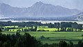
Lower reaches of the Swat River valley
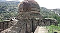
The Amluk-Dara stupa, one of many ancient Buddhist sites scattered throughout the river's valley


See also[]
- Rigvedic rivers
- Swat, Pakistan
- Barikot
References[]
- Book: Hidden Treasures of Swat, ISBN 978-969-23042-0-7
- ^ Susan Whitfield (2018). Silk, Slaves, and Stupas: Material Culture of the Silk Road. University of California Press. p. 136. ISBN 978-0-520-95766-4.
- ^ Macdonell, Arthur Anthony (1900). A History of Sanskrit Literature. D. Appleton.
the Suvastu, river "of fair dwellings" (now Swat)
- ^ Vidyalankar, Satyakam (1977). R̥gveda Saṃhitā. Veda Pratishthan.
The word suvastu means “ having fair dwellings '
- ^ Roy, S. B. (1989). Early Aryans of India, 3100-1400 B.C. Navrang. ISBN 978-81-7013-052-9.
, Suvastu ( Swat or with fair dwellings )
- ^ Laet, Sigfried J. de; Dani, Ahmad Hasan (1 January 1994). History of Humanity: From the third millennium to the seventh century B.C. UNESCO. ISBN 978-92-3-102811-3.
The word suvastu signifying 'fair dwellings' seems to indicate that there were Aryan settlements along its banks.
- ^ "History". www.wapda.gov.pk. Retrieved 22 April 2021.
- ^ Report, Bureau (28 August 2010). "Munda Headworks restored in record time". DAWN.COM. Retrieved 22 April 2021.
- ^ http://wapda.gov.pk/vision2025/htmls_vision2025/munda.htm
External links[]
| Wikimedia Commons has media related to Swat River. |
Coordinates: 34°07′N 71°43′E / 34.117°N 71.717°E

| hide Authority control | |
|---|---|
| General | |
| National libraries | |
- Rivers of Khyber Pakhtunkhwa
- Kabul River
- Swat District
- Rigvedic rivers
- Rivers in Buddhism
- Rivers of Pakistan