Szydłów
Szydłów | |
|---|---|
Town | |
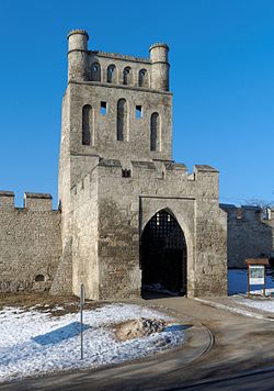 The Kraków Gate in Szydłów | |
 Coat of arms | |
 Szydłów | |
| Coordinates: 50°35′28″N 21°00′13″E / 50.59111°N 21.00361°ECoordinates: 50°35′28″N 21°00′13″E / 50.59111°N 21.00361°E | |
| Country | |
| Voivodeship | Świętokrzyskie |
| County | Staszów |
| Gmina | Szydłów |
| Sołectwo | Szydłów |
| Elevation | 250.6 m (822.2 ft) |
| Population (31 December 2009 at Census)[1] | |
| • Total | |
| Time zone | UTC+1 (CET) |
| • Summer (DST) | UTC+2 (CEST) |
| Postal code | 28-225 |
| Area code(s) | +48 41 |
| Car plates | TSZ |
| Website | www.szydlow.pl |

Szydłów[2][3][4] [ˈʂɨdwuf] is a fortified town in Staszów County, Świętokrzyskie Voivodeship, in southeastern Poland. It is the seat of the gmina (administrative district) called Gmina Szydłów. It lies approximately 13 kilometres (8 mi) west of Staszów and 43 km (27 mi) south-east of the regional capital Kielce.[5] The village has a population of 1,093.
Szydłów's history dates to the 12th century. It gained its city rights in 1329 and lost them in 1869. The village contains several tourist attractions, including the 16th-century Szydłów Synagogue, several buildings and churches dating to the 14th century and the ruins of a castle from the same period. The first official inventory of important buildings in Poland, A General View of the Nature of Ancient Monuments in the Kingdom of Poland, led by Kazimierz Stronczyński from 1844–55, describes the Szydłów Synagogue as one of Poland's architecturally notable buildings.[6]
Location[]
Szydłów is located in Lesser Polish Upland, between the Świętokrzyskie Mountains and the Połaniec Plain. The village lies within borders of Chmielnik–Szydłów Protected Landscape Area. The distance to Kielce is 40 kilometers, to Staszów 12 kilometers. Due to numerous plum orchards, the village is called Plum Capital of Poland. Every year, the Plum Festival takes place here. The village is crossed by two regional roads—765th and 756th; furthermore, Szydłów is a stop along Lesser Polish Way.
History[]
First mention of Szydłów comes from the year 1191, in documents of Sandomierz Collegiate church. At that time, the village was owned by Polish Kings, located along the Vistula merchant road, which was of major importance in the late Middle Ages. On July 1, 1329, Szydłów was incorporated as a town on Środa Śląska town law (see also: Magdeburg rights).
In the mid-14th century, King Casimir III the Great founded here a fortified castle and the Church of Saint Ladislaus. The town was surrounded by a defensive wall, with three gates—Kraków Gate, Opatów Gate, and Water Gate. Soon afterwards, Szydłów became the seat of a starosta, and first artisans came here, as well as Jewish settlers. The town was located in Lesser Poland's Sandomierz Voivodeship, and its location helped wine, cattle and hops merchants, who would go with their goods to Sandomierz. In the 16th century, Szydłów emerged as a center of cloth-making. Also, tailors, bakers, shoemakers, iron smiths, saddle makers, sword makers and pot makers worked here, there also was a brewery. In 1528, waterworks and bath houses were opened, and in 1564, the town had 180 houses, of which 49 were located on the market square, but next year, large parts of Szydłów burned in a fire. At that time, a number Jews settled in the town, who in 1534–1564 built first synagogue.
Good times came to an end in the first half of the 17th century. In 1630 Szydłów was burned by rebellious soldiers of fortune, who were not paid their salaries. Unable to enter the fortified town, the mercenaries set the suburbs on fire, and the blaze reached Szydłów. Swedish invasion of Poland (1655–1660), and the invasion of troops of George II Rakoczi (see Treaty of Radnot) brought almost complete destruction, after which town's population shrank from 1,300 to 350, and the number of houses was reduced to 54 (as for 1663). After these conflicts, Szydłów never recovered to its previous prosperity. In 1789, Szydłów had a stone town hall, 5 mills on the Ciekąca river and 196 houses, many of them abandoned. The castle was ruined, and by 1827, the number of houses grew to 202, and the population reached 1,550.
After the third partition of Poland (1795), Szydłów was annexed by the Austrian Empire, but in 1809 it became the seat of a county in the Duchy of Warsaw. In 1815 it became part of Congress Poland, and in 1850, Russian authorities liquidated Szydłów County, merging it with Stopnica County. In 1869, as a punishment for participation of residents in the January Uprising, Szydłów was reduced to the status of a village.
In 1929 Szydłów, already part of Kielce Voivodeship, had 2,246 inhabitants, of which 30% were Jews. During World War II, part of the town, and almost all of its Jewish population, were destroyed. At the beginning of the war, between 500 and 600 Jews lived in the town. Immediately on occupying Szydłów, the Germans robbed and plundered Jewish homes and shops. They would randomly shoot and torture Jewish men. Men were also conscripted for forced labor. In 1940, Germans forced Jews from other towns in the region into Szydłów, doubling the Jewish population. By the end of 1941, more than 1000 Jews were in Szydłów with more Jews deported there periodically. In October 1942, 150 Jews were sent to labor camps, fifteen Jews were shot in Szydłów, and the remaining Jews, then numbering about 1000, were marched to the Szczucin train station and sent to the Treblinka killing camp where they were immediately murdered. The number of Szydłów Holocaust survivors is unknown. [7]
In 1960 the population was 1,402. On 1 January 2019, Szydłów regained its town status.
Points of interest[]
- Medieval town center, with a 700-meter long defensive wall. Out of three gates, only Kraków Gate still exists.
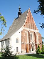
- St. Stanisław Church (14th century)
- Gothic All Saints Church (14th–15th century)
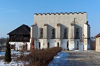
- 14th-century Royal Castle in Szydłów, rebuilt in the 16th century. Main building of the complex is in ruins, currently the castle has a library and a museum. It is entered through a 17th-century gate.
- Ruins of the Holy Spirit Church and Hospital (16th century)
- Late-Renaissance synagogue (16th century), which now houses a Jewish Culture Museum.
Saint Władysław Church

Szydłów Church

Old Church ruins

Courtyard of the Castle

Szydłów Castle
Szydłów Synagogue before renovation


Demography[]
According to the 2002 Poland census, there were 1,054 people residing in Szydłów village, of whom 50.7% were male and 49.3% were female. In the village, the population was spread out, with 23.6% under the age of 18, 37.4% from 18 to 44, 20.5% from 45 to 64, and 18.5% who were 65 years of age or older.[1]
Table 1. Population level of village in 2002—by age group[1] SPECIFICATION Measure
unitPOPULATION
(by age group in 2002)TOTAL 0–9 10–19 20–29 30–39 40–49 50–59 60–69 70–79 80 + I. TOTAL person 1,054 118 172 135 126 175 122 67 86 53 — of which in % 100 11.2 16.3 12.8 12 16.6 11.6 6.4 8.2 5 1. BY SEX A. Males person 534 67 96 81 59 88 63 21 35 24 — of which in % 50.7 6.4 9.1 7.7 5.6 8.3 6 2 3.3 2.3 B. Females person 520 51 76 54 67 87 59 46 51 29 — of which in % 49.3 4.8 7.2 5.1 6.4 8.3 5.6 4.4 4.8 2.8
Figure 1. Population pyramid of village in 2002 — by age group and sex[1]
Table 2. Population level of village in 2002 — by sex[1] SPECIFICATION Measure
unitPOPULATION
(by sex in 2002)TOTAL Males Females I. TOTAL person 1,054 534 520 — of which in % 100 50.7 49.3 1. BY AGE GROUP A. At pre-working age person 249 140 109 — of which in % 23.6 13.3 10.3 B. At working age. grand total person 610 325 285 — of which in % 57.9 30.8 27.1 a. at mobile working age person 394 210 184 — of which in % 37.4 19.9 17.5 b. at non-mobile working age person 216 115 101 — of which in % 20.5 10.9 9.6 C. At post-working age person 195 69 126 — of which in % 18.5 6.5 12

See also[]
- The Lesser Polish Way
References[]
- ^ a b c d e "Local Data Bank (Bank Danych Lokalnych) – Layout by NTS nomenclature (Układ wg klasyfikacji NTS)". demografia.stat.gov.pl: GUS. 10 March 2011.
- ^ Bielec, Jan (ed.); Szwałek, Stanisława (1982). Wykaz urzędowych nazw miejscowości w Polsce. T. III: P – Ż [List of official names of localities in Poland, Vol. III: P – Ż] (in Polish). Ministry of Administration, Spatial Economy and Environmental Protection (1st ed.). Warsaw, Poland: Central Statistical Office.CS1 maint: extra text: authors list (link)
- ^ Sitek, Janusz (1991). Nazwy geograficzne Rzeczypospolitej Polskiej [Geographical names of the Republic of Poland] (in Polish). Ministry of Physical Planning and Construction, Surveyor General of Poland, Council of Ministers' Office, Commission for Establishing Names of Localities and Physiographical Objects (1st ed.). Warsaw, Poland: Eugeniusz Romer State Cartographical Publishing House. ISBN 83-7000-071-1.
- ^ "Szydłów, wieś, gmina Szydłów, powiat staszowski, województwo świętokrzyskie" [Szydłów, village, Szydłów Commune, Staszów County, Świętokrzyskie Province, Poland]. Topographical map prepared in 1:10,000 scale. Aerial and satellite orthophotomap (in Polish). Head Office of Geodesy and Cartography, Poland, Warsaw. 2011. geoportal.gov.pl. Retrieved 27 April 2011.
- ^ "Central Statistical Office (GUS) - TERYT (National Register of Territorial Land Apportionment Journal)" (in Polish). 2008-06-01.
- ^ Heaven's Gates; Wooden synagogues in the Territories of the Former Polish-Lithuanian Commonwealth, Maria and Kazimierz Piechotka, Wydawnictwo Krupski i S-ka, Warsaw, 2004, p. 174
- ^ Megargee, Geoffrey (2012). Encyclopedia of Camps and Ghettos. Bloomington, Indiana: University of Indiana Press. p. Volume II 329-330. ISBN 978-0-253-35599-7.
External links[]
 Media related to Szydłów (województwo świętokrzyskie) at Wikimedia Commons
| Seat |  | |
|---|---|---|
| Other villages | ||
| Parts of village |
| |
| Hamlets of village |
| |
- Villages in Staszów County
- Sandomierz Voivodeship
- Kielce Governorate
- Kielce Voivodeship (1919–1939)
- Holocaust locations in Poland