Tamentfoust
 Tamentfoust port | |
 Shown within Algeria | |
| Alternative name | Rusguniae La Pérouse |
|---|---|
| Location | Algeria |
| Region | Algiers Province |
| Coordinates | 36°45′00″N 5°04′00″E / 36.75°N 5.066667°E |
| Cap Matifou Lighthouse | |
 | |
| Coordinates | 36°48′42.2″N 3°14′43.29″E / 36.811722°N 3.2453583°E |
| Constructed | 1868 |
| Foundation | masonry base |
| Construction | masonry tower |
| Tower height | 6 metres (20 ft) |
| Tower shape | quadrangular tower with balcony and light attached to 1-storey keeper’s house |
| Markings | white tower |
| Operator | Office Nationale de Signalisation Maritime |
| Focal height | 74 metres (243 ft)[1] |
| Light source | main power |
| Range | 23 nautical miles (43 km; 26 mi)[1] |
| Characteristic | Fl (3) W 15s.[1] |
| Admiralty no. | E6594 |
| NGA no. | 22368 |
| ARLHS no. | ALG-014[2] |

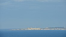
Tamentfoust (Arabic: تمنتفوست), the classical Rusguniae and colonial La Pérouse, is a site in the Dar El Beïda District of Algiers in Algeria.
Geography[]
Tamentfoust lies on , which forms the northeast side of the .
Names[]
The Roman name Rusguniae is a latinization of the Punic name RŠGNY (