Tarporley
| Tarporley | |
|---|---|
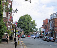 High Street | |
 Tarporley Location within Cheshire | |
| Population | 2,614 (2011 census) |
| OS grid reference | SJ553627 |
| Civil parish |
|
| Unitary authority |
|
| Ceremonial county |
|
| Region |
|
| Country | England |
| Sovereign state | United Kingdom |
| Post town | TARPORLEY |
| Postcode district | CW6 |
| Dialling code | 01829 |
| Police | Cheshire |
| Fire | Cheshire |
| Ambulance | North West |
| UK Parliament | |

Tarporley is a large village and civil parish in the unitary authority of Cheshire West and Chester and the ceremonial county of Cheshire, England. The civil parish also contains the village of Rhuddall Heath. Tarporley is bypassed by the A49 and A51 roads, and holds a regular country market on the first Saturday of each month.
At the 2001 census, the population was 2,634,[1] falling slightly to 2,614 in the 2011 census.[2]
Tarporley High Street features four pubs: the Foresters Arms, the Swan Hotel, the Crown Hotel, and the Rising Sun. The High Street is also home to three restaurants: Piste, The Coast Restaurant and Bar,[3] and Little Tap.[4]
The Tarporley Hunt Club, the oldest surviving hunt club in England,[5][6] meets in the village every Christmas.
History[]
Tarporley is near the site of a prehistoric settlement.[citation needed] Several prehistoric artefacts have been discovered within close proximity of the present-day village: a Neolithic stone axe, a flint scraper and a Bronze Age barbed and tanged arrow head.[7]
It is listed in the Domesday Book as Torpelei,[8] which has been translated as meaning “a pear wood near a hill called Torr”.[9] For this reason, Tarporley Church of England Primary School has a pear tree for its emblem. However, the exact origins and meaning are unclear. The name has also been suggested to mean "a peasant's wood/clearing", derived from the Old English words þorpere (someone who lives at a thorp; a peasant) and lēah (a wood, forest, glade or clearing)[10]
In 1066, the settlement was owned by Wulfgeat of Madeley and was worth one pound. Twenty years later, under the ownership of Gilbert the Hunter (Gilbert de Venables), Tarporley's value had halved, to ten shillings. This small agricultural settlement comprised eight households (four villagers, two smallholders and two slaves).[11] The Domesday entry suggests that Tarporley was one of many townships still recovering from the devastation caused by the Norman's Harrying of the North in 1069-70.[7]
Governance[]
An electoral ward of the same name exists. This ward stretches north-east to the Budworths with a total population at the 2011 census of 4,398.[12]
Civic history[]
At Domesday, Tarporley was a township and ancient parish in the Hundred of Rushton,[11] but by the late 12th century it had become part of Eddisbury Hundred. From 1866, the village has had civil parish status[13] and its parish council gives it some limited local government autonomy. The parish council comprises 12 locally elected members.[14]
Tarporley Urban District was created in 1894 and was abolished in 1936.[15] From 1936 until 1974 Tarporley was a part of Northwich Rural District, until that district's abolition as a result of the Local Government Act 1972.[16] From 1 April 1974 Tarporley formed part of the borough of Vale Royal, within Cheshire and was included in the new unitary authority of Cheshire West and Chester on 1 April 2009.
Political representation[]
Tarporley has been in the parliamentary constituency of Eddisbury since that constituency's re-establishment in 1983, following its abolition in 1950. The constituency has been represented by Conservative MPs since its re-establishment: Edward Timpson (since 2019),[17] Stephen O'Brien (1999–2015) and Antoinette Sandbach (2015–19).
Demography[]
| Population of Tarporley since 1801 | |||||||||||||||||||||
|---|---|---|---|---|---|---|---|---|---|---|---|---|---|---|---|---|---|---|---|---|---|
| Year | 1801 | 1851 | 1901 | 1951 | 2001 | 2011 | |||||||||||||||
| Population | 674 | 1,171 | 1,454 | 1,538 | 2,634 | 2,614 | |||||||||||||||
| Sources:[13][1][2] | |||||||||||||||||||||

Geography and transport[]
Tarporley is bypassed by the A49 and A51 roads. The village was once served by Beeston Castle and Tarporley railway station on the North Wales Coast Line between Crewe and Chester, more than two miles from the village; the line remains open but the station closed in April 1966.
A local bus service, route 84, is provided by Arriva Buses Wales.

Education[]
Tarporley has two schools: Tarporley High School and Tarporley Church of England Primary School.
Brook Farm School was a state special education boarding school located in the village that closed in 2001 and was demolished in 2013.
Twinning[]
Established in 1983, through The British Council, Tarporley is twinned with the Breton village of Bohars, near Brest, France.[18]
See also[]
References[]
Notes
- ^ Jump up to: a b UK Census (2001). "Local Area Report – Tarporley Parish (13UH038)". Nomis. Office for National Statistics. Retrieved 3 July 2021.
- ^ Jump up to: a b UK Census (2011). "Local Area Report – Tarporley Parish (E04011173)". Nomis. Office for National Statistics. Retrieved 3 July 2021.
- ^ "Home page". The Coast. Retrieved 4 January 2017.
- ^ "Little Tap". TripAdvisor. Retrieved 7 July 2017.
- ^ Atkinson, D. (2004). "Warburton, Rowland Eyles Egerton (1804–1891)". Oxford Dictionary of National Biography. Oxford University Press. Retrieved 11 May 2010.(subscription or UK public library membership required)
- ^ Butler, L. (20 November 2009). "Tarporley Hunt Cup goes under the hammer". Horse and Hound. Retrieved 11 May 2010. Archived 10 June 2011 at the Wayback Machine
- ^ Jump up to: a b "Archaeological Assessment: Tarporley" (PDF). Cheshire Historic Towns Survey. Cheshire County Council/English Heritage. 2003. Retrieved 3 July 2021.
- ^ "Cheshire L-Z: Tarporley". Domesday Book Online. Retrieved 3 July 2021.
- ^ Dodgson, J. McN (1971). The Place-Names of Cheshire (Part III): The Place-Names of Nantwich Hundred and Eddisbury Hundred. Cambridge University Press. ISBN 0-521-08049-5.
- ^ "Key to English Place-Names: Tarporley". University of Nottingham. Retrieved 3 July 2021.
- ^ Jump up to: a b Powell-Smith, Anna. "Tarporley". Open Domesday/University of Hull. Retrieved 3 July 2021.
- ^ "Ward population 2011". UK Census Data. Retrieved 30 May 2015.
- ^ Jump up to: a b "Tarporley". GENUKI UK & Ireland Genealogy. Retrieved 3 July 2021.
- ^ "Councillors". Tarporley Parish Council. Retrieved 21 January 2008.
- ^ "Tarporley AP/CP". A Vision of Britain Through Time. GB Historical GIS / University of Portsmouth. Retrieved 21 January 2008.
- ^ "Tarporley UD". A Vision of Britain Through Time. GB Historical GIS / University of Portsmouth. Retrieved 21 January 2008.
- ^ "Eddisbury Parliamentary constituency". BBC. Retrieved 19 December 2019.
- ^ "Tarporley Twinning Association". Retrieved 10 December 2013.
External links[]
| Wikimedia Commons has media related to Tarporley. |
- Tarporley
- Civil parishes in Cheshire
- Villages in Cheshire