Taupō
Taupō
Taupō-nui-a-Tia (Māori) | |
|---|---|
 | |
 Taupō | |
| Coordinates: 38°41′15″S 176°04′10″E / 38.6875°S 176.0694°ECoordinates: 38°41′15″S 176°04′10″E / 38.6875°S 176.0694°E | |
| Country | |
| Island | North Island |
| Region | Waikato |
| Territorial authority | Taupō District |
| Ward | Taupō-Kaingaroa |
| Settled | pre-European |
| Founded | 1869 |
| Borough status | 1953 |
| Named for | originates from Taupō-nui-a-Tia, meaning "great cloak of Tia" in Māori |
| Electorate | Taupō |
| Government | |
| • Mayor | David Trewavas |
| Area | |
| • Urban | 42.95 km2 (16.58 sq mi) |
| • District | 6,970 km2 (2,690 sq mi) |
| Elevation | 360 m (1,180 ft) |
| Population (June 2020)[1] | |
| • Urban | 25,400 |
| • Urban density | 590/km2 (1,500/sq mi) |
| • District | 40,100 |
| • District density | 5.8/km2 (15/sq mi) |
| Time zone | UTC+12 (NZST) |
| • Summer (DST) | UTC+13 (NZDT) |
| Postcode | 3330 |
| Area code(s) | 07 |
| Local iwi | Ngāti Tūwharetoa |

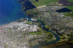
Taupō, sometimes spelled Taupo, (Māori pronunciation: [ˈtoʊpɔː]) is a town on the north-eastern shore of Lake Taupo in the central North Island of New Zealand. The town is the largest urban area and the seat of the Taupo District, and the second-largest urban area in the Waikato region behind Hamilton.
Taupō has a population of 25,400 (June 2020).[1] In 1953, Taupō was officially constituted as a borough,[2] but from 1989 it has been administered by the Taupo District Council, the district including both Taupō itself and the surrounding hinterland. Despite this, it is occasionally referred to as a city.
The name Taupō, by which the town is commonly known, is the shortened version of the lake’s Māori name, Taupō-nui-a-Tia. Literally translated, Taupō-nui-a-Tia means "The great cloak of Tia", the explorer who discovered the lake. In 2019 the official name of the town was changed from Taupo to Taupō.[3][4]
Geographical features[]
Taupō is located on the northeastern shore of Lake Taupo, New Zealand's largest lake, which is itself in the caldera of the Taupo Volcano. The Waikato River drains the lake and runs through the town, separating the CBD and the northern suburbs. The river flows over the spectacular Huka Falls, a short distance north of the town, Taupō is a centre of volcanic and geothermal activity, and hot springs suitable for bathing are located at several places in the vicinity. The volcanic Mount Tauhara lies six kilometres (4 mi) to the east.
Somewhat to the northeast are significant hot springs. These springs contain extremophile micro-organisms that live in extremely hot environments.
The small but growing satellite town of Kinloch, where there is a golf course designed by Jack Nicklaus, is 20 kilometres west along the lake.

Neighbourhoods[]
- Inner suburbs
Taupō neighbourhoods include:
- Wharewaka – has a popular swimming spot for locals and a growing new subdivision along with a large retirement village.
- Nukuhau – lies north of the Waikato River. To the south-west lies Acacia Bay and to the south lies Taupo town centre.
- Richmond Heights – lies to the east of Rainbow Point and south of Mountain View. It is home to the Richmond Heights shopping center.
- Waipahihi – lies to the north of Richmond Heights. It is home to the Waipahihi Primary School, and the Waipahihi Botanical Gardens.
- Mount View
- Acacia Bay
- Rainbow Point – lies north of Wharewaka and west of Richmond Heights. To the west lies Lake Taupo.
- Tauhara – lies just north of Hilltop and east of Mount View. Mount Tauhara lies just east of Tauhara. Tauhara is the location of Tauhara primary school, Tauhara College and Tauhara Golf course.
- Hilltop – lies south of Tauhara. Hilltop is the location of Hilltop School, Taupo Intermediate School, the Taupo Hospital, the Taharepa shopping centre and the Hilltop shopping centre.
- Taupo CBD
- Five Mile Bay – is located on the east side of Lake Taupo, south of Wharewaka and north of Waitahanui on State Highway 1 just west of the Taupo Airport. It is a popular swimming/water skiing beach which gets very busy in summer. Five Mile Bay is one of three similar named bays along the lake shoreline, the others being Two Mile Bay and Three Mile Bay.
- Outer suburbs
- Wairakei
- Waitahanui
Climate[]
The climate of Taupō is cold and windy when compared to other parts of the North Island and has an oceanic climate (Cfb). This is due to the town being located inland, which results in the accumulation of dry air causing severe frost during winter. However snowfall in Taupō is rare. The summer climate in Taupō is mild with maximum average temperature reaching 23 degrees and a minimum average temperature of 10 degrees.
| hideClimate data for Taupo | |||||||||||||
|---|---|---|---|---|---|---|---|---|---|---|---|---|---|
| Month | Jan | Feb | Mar | Apr | May | Jun | Jul | Aug | Sep | Oct | Nov | Dec | Year |
| Average high °C (°F) | 22.7 (72.9) |
22.6 (72.7) |
20.4 (68.7) |
17.2 (63.0) |
14.1 (57.4) |
11.7 (53.1) |
11.0 (51.8) |
11.9 (53.4) |
13.9 (57.0) |
15.8 (60.4) |
18.3 (64.9) |
20.7 (69.3) |
16.9 (62.4) |
| Daily mean °C (°F) | 17.0 (62.6) |
17.1 (62.8) |
14.9 (58.8) |
12.0 (53.6) |
9.4 (48.9) |
7.4 (45.3) |
6.5 (43.7) |
7.2 (45.0) |
9.2 (48.6) |
11.1 (52.0) |
13.1 (55.6) |
15.6 (60.1) |
11.7 (53.1) |
| Average low °C (°F) | 11.4 (52.5) |
11.6 (52.9) |
9.5 (49.1) |
6.8 (44.2) |
4.8 (40.6) |
3.0 (37.4) |
2.1 (35.8) |
2.7 (36.9) |
4.5 (40.1) |
6.4 (43.5) |
7.9 (46.2) |
10.5 (50.9) |
6.7 (44.1) |
| Average precipitation mm (inches) | 77.3 (3.04) |
67.9 (2.67) |
66.5 (2.62) |
68.4 (2.69) |
74.9 (2.95) |
92.8 (3.65) |
96.0 (3.78) |
87.4 (3.44) |
81.6 (3.21) |
86.2 (3.39) |
67.9 (2.67) |
93.6 (3.69) |
960.3 (37.81) |
| Average precipitation days (≥ 1 mm) | 7.7 | 6.7 | 7.3 | 7.4 | 8.7 | 10.9 | 10.9 | 11.4 | 10.7 | 10.6 | 8.2 | 9.2 | 109.6 |
| Mean monthly sunshine hours | 224.3 | 202.6 | 179.7 | 156.3 | 126.3 | 96.1 | 116.5 | 134.6 | 140.0 | 179.6 | 190.4 | 204.6 | 1,950.9 |
| Source: NIWA Climate Data[5] | |||||||||||||
Demographics[]
As of June 2020, Taupō had a estimated population of 25,400. It is the 25th largest urban area in New Zealand, and the second-largest in the Waikato Region (behind Hamilton).[1]
The Taupō urban area had a population of 23,622 at the 2018 New Zealand census, an increase of 2,499 people (11.8%) since the 2013 census, and an increase of 2,925 people (14.1%) since the 2006 census. There were 11,523 males and 12,099 females, giving a sex ratio of 0.95 males per female. Of the total population, 4,740 people (20.0%) were aged up to 15 years, 3,836 (16.2%) were 15 to 29, 10,167 (43.0%) were 30 to 64, and 4,872 (20.6%) were 65 or older.[6]
Ethnicities were 79.8% European/Pākehā, 24.5% Māori, 3.3% Pacific peoples, 5.7% Asian, and 1.9% other ethnicities (totals add to more than 100% since people could identify with multiple ethnicities).[6]
| SA2 name | Population | Dwellings | Median age | Median income |
|---|---|---|---|---|
| Acacia Bay | 1,653 | 987 | 50.8 years | $39,600 |
| Bird Area | 2,235 | 1,155 | 43.3 years | $34,900 |
| Brentwood | 1,893 | 891 | 48.2 years | $31,600 |
| Hilltop | 2,721 | 1,236 | 42.2 years | $29,600 |
| Mountview | 2,601 | 1,116 | 34.8 years | $28,900 |
| Nukuhau-Rangatira Park | 2,442 | 1,206 | 44.6 years | $31,700 |
| Richmond Heights | 2,328 | 1,143 | 37.2 years | $32,500 |
| Tauhara | 1,803 | 681 | 30.4 years | $26,400 |
| Taupō Central East | 2,439 | 1,083 | 35.8 years | $25,400 |
| Taupō Central West | 405 | 222 | 32.1 years | $31,100 |
| Waipahihi | 2,172 | 1,125 | 46.4 years | $36,300 |
| Wharewaka | 939 | 726 | 57.5 years | $30,200 |
Economy[]
Taupō is a tourist centre, particularly in the summer, as it offers panoramic views over the lake and to the volcanic mountains of Tongariro National Park to the south. It offers a number of tourist activities including sky diving, , paragliding, and bungy jumping.
Taupō services a number of surrounding plantation pine forests including the large Kaingaroa Forest and related industry. A large sawmill is sited approximated 3 km to the north east of the town on Centennial Drive.
Taupō is surrounded by seven geothermal power stations including the historic Wairakei geothermal power station a few kilometres north of the town.
Sporting events[]
Some regular sporting events in Taupō include Ironman New Zealand, the Lake Taupō Cycle Challenge and the Great Lake Relay (established in 1995).[8][9] The Lake Taupō Cycle Challenge has about 5,000 riders.[10] The Oxfam Trailwalker has been held in Taupō several times.[11][12] In 2006 Taupō was also the location of the off-road motorcycle event FIM International Six Day Enduro.
The International Mountain Bicycling Association has designated the mountain biking trails at Bike Taupō as a silver-level IMBA Ride Center.[13] Ride Centers are the IMBA's strongest endorsement of a trail experience.[14]

Education[]
Taupō has four high schools: Tauhara College, Taupo-nui-a-Tia College, Māori immersion and state integrated Lake Taupo Christian School. It also has Wairakei, St Patrick's, Waipahihi, Hilltop, Mount View, Taupō and Tauhara primary schools, and Taupo Intermediate School.
Infrastructure and services[]
Transport[]
Taupō is served by State Highway 1 and State Highway 5, and the touring route. All three highways run concurrently along the Eastern Taupo Arterial, which was built in 2010.[15]
Taupō is one of the few large towns in New Zealand that have never had a link to the national rail network, although there have been proposals in the past.
Taupo Airport is located south of the township. Scheduled services to Auckland and Wellington operate from the airport.[16]
Utilities[]
Taupō didn't receive a public electricity supply until 1952, with the commissioning of the Hinemaiaia A hydroelectric power station south of the town. The town was connected to the national grid in 1958, coinciding with the commissioning of Wairakei geothermal power station north of the town.[17] Today, Unison Networks owns and operates the electricity distribution network in Taupō.[18]
Natural gas arrived in Taupō in 1987, with First Gas operates the gas distribution network within the town.[19]
Taupō's fresh water supply is drawn from Lake Taupō. Prior to 2013, there were two separate fresh water systems serving the town: the Lake Terrace system serving the town north of Napier Road, and the Rainbow Point system serving the southern suburbs. In 2013, the Lake Terrace treatment plant was upgraded and the two systems were amalgamated. Acacia Bay has its own dedicated fresh water system.[20]
Notable people[]
- Patrick Bevin (born 1991), road racing cyclist
- Bevan Docherty (born 1977), Olympic triathlete
- James Tito actor and musician
- Louisa Wall (born 1972), member of parliament and former national representative netball and rugby union player
Twin cities[]
Taupō is twinned with:
See also[]
References[]
- ^ Jump up to: a b c "Population estimate tables - NZ.Stat". Statistics New Zealand. Retrieved 22 October 2020.
- ^ "Taupo". Encyclopedia of New Zealand (1966).
- ^ "NZGB Gazetteer | linz.govt.nz". gazetteer.linz.govt.nz. Retrieved 20 January 2021.
- ^ "Over 800 Māori place names made official". TVNZ. Retrieved 20 January 2021.
- ^ "Climate Data". NIWA. Retrieved 2 November 2007.
- ^ Jump up to: a b "Age and sex by ethnic group (grouped total response), for census usually resident population counts, 2006, 2013, and 2018 Censuses (urban rural areas)". nzdotstat.stats.govt.nz. Retrieved 13 September 2020.
- ^ "2018 Census place summaries | Stats NZ". www.stats.govt.nz. Retrieved 14 December 2020.
- ^ "IMNewZealand". Ironman. Retrieved 20 January 2021.
- ^ "Taupo Great Lake Relay – Event Promotions". Event Promotions. Retrieved 20 January 2021.
- ^ "Welcome - Lake Taupō Cycle Challenge". Cycle Challenge. Retrieved 20 January 2021.
- ^ "Oxfam Trailwalker in New Zealand Search". Eventfinda. Archived from the original on 20 January 2021. Retrieved 20 January 2021.
- ^ "Past Events". Oxfam Trailwalker. Retrieved 20 January 2021.
- ^ "Introducing the 2012 Model Trail Awards Winners; International Mountain Bicycling Association". Imba.com. Retrieved 15 June 2016.
- ^ "Pocahontas State Park to Develop Regional Biking Center – Richmond Times-Dispatch: Outdoor Recreation In Richmond And Central Virginia". Richmond.com. 10 July 2013. Retrieved 15 June 2016.
- ^ "Taupo reflects on bypass road success | NZNews | Newshub". 3news.co.nz. 29 December 2012. Retrieved 15 June 2016.
- ^ "Sounds Air Flying Wellington to Taupo". Great Lake Taupō. Retrieved 15 June 2016.
- ^ "Hinemaiaia Power Scheme". www.trustpower.co.nz. Retrieved 24 August 2021.
- ^ "Unison's history". www.unison.co.nz. Retrieved 24 August 2021.
- ^ "The New Zealand Gas Story". Gas Industry Company. December 2016. Archived from the original on 2 February 2017. Retrieved 31 October 2018.
- ^ "Asset management plan - Water" (PDF). Taupo District Council. Retrieved 24 August 2021.
External links[]
| Wikimedia Commons has media related to Taupo. |
| Wikivoyage has a travel guide for Taupo. |
| Authority control |
|
|---|
- Populated places in Waikato
- Taupo District