Tavoleto
Tavoleto | |
|---|---|
| Comune di Tavoleto | |
 | |
 Coat of arms | |
show Location of Tavoleto | |
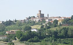
 Tavoleto Location of Tavoleto in Italy | |
| Coordinates: 43°51′N 12°36′E / 43.850°N 12.600°E | |
| Country | Italy |
| Region | Marche |
| Province | Pesaro e Urbino (PU) |
| Frazioni | Casinella |
| Government | |
| • Mayor | Stefano Pompei |
| Area | |
| • Total | 12.0 km2 (4.6 sq mi) |
| Elevation | 426 m (1,398 ft) |
| Population (31 October 2020)[3] | |
| • Total | 852 |
| • Density | 71/km2 (180/sq mi) |
| Demonym(s) | Tavoletani |
| Time zone | UTC+1 (CET) |
| • Summer (DST) | UTC+2 (CEST) |
| Postal code | 61020 |
| Dialing code | 0722 |
| Patron saint | St. Lawrence |
| Saint day | August 10 |
| Website | Official website |


Tavoleto is a comune (municipality) with some 868 inhabitants in the Province of Pesaro e Urbino in the Italian region Marche, located about 80 kilometres (50 mi) northwest of Ancona and about 25 kilometres (16 mi) southwest of Pesaro.
Tavoleto borders the following municipalities: Mercatino Conca, Mondaino, Monte Cerignone, Montefiore Conca, Saludecio, Sassocorvaro Auditore, Urbino.
References[]
- ^ "Superficie di Comuni Province e Regioni italiane al 9 ottobre 2011". Istat. Retrieved 16 March 2019.
- ^ "Popolazione Residente al 1° Gennaio 2018". Istat. Retrieved 16 March 2019.
- ^ All demographics and other statistics: Italian statistical institute Istat.
| Authority control |
|
|---|
Categories:
- Cities and towns in the Marche
- Municipalities of the Province of Pesaro and Urbino
- Marche geography stubs