Teapot Rock
Teapot Rock | |
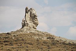 Teapot Rock in 2017 | |
 | |
| Location | Natrona County, Wyoming, US |
|---|---|
| Nearest city | Midwest, Wyoming |
| Coordinates | 43°14′0″N 106°18′40″W / 43.23333°N 106.31111°WCoordinates: 43°14′0″N 106°18′40″W / 43.23333°N 106.31111°W |
| Built | 1922 |
| NRHP reference No. | 74002028[1] |
| Added to NRHP | December 30, 1974 |


Teapot Rock, also known as Teapot Dome, is a distinctive sedimentary rock formation in Natrona County, Wyoming that lent its name to a nearby oil field that became notorious as the focus of the Teapot Dome scandal, a bribery scandal during the presidential administration of Warren G. Harding. The site was listed on the National Register of Historic Places in 1974.[1]
Description[]
The eroded sandstone formation stands about 75 feet (25 m) tall and is about 300 feet (90 m) in circumference. It is located a few hundred yards east of Wyoming Highway 259, about 19 miles (30 km) north of Casper, Wyoming in the Powder River Basin near Teapot Creek, a tributary of Salt Creek.[2]
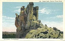
The outline of the rock once resembled a teapot and gave its name to several man-made and natural features, including a geologic structural uplift known as the Teapot Dome, and an oil field about 6 miles (10 km) east.[1] Over time, the features that gave the formation its name have been eroded by windstorms; the "handle" disappeared in 1930 and the "spout" in 1962.[3]
History[]
In 1915, the Teapot Dome Oil Field was designated Naval Petroleum Reserve Number Three as part of a program to ensure that the U.S. Navy, which was converting to oil-fired boilers at the time, would have sufficient fuel reserves in an emergency.[2][4] It was one of several related fields in the area, the largest of which was the Salt Creek Oil Field. By comparison with the Salt Creek Field's peak production of 35,301,608 barrels (5,612,507.2 m3) of 1923, the Teapot Dome field had about 64 wells, with a few producing more than 150 barrels per day (24 m3/d).[2]
In February 2015, the field was sold by the Department of Energy.[5][6]
References[]
- ^ Jump up to: a b c "National Register Information System". National Register of Historic Places. National Park Service. March 13, 2009.
- ^ Jump up to: a b c Junge, Mark (June 1974). "National Register of Historic Places Inventory Nomination Form: Teapot Rock". National Park Service. Retrieved 2009-08-07.
- ^ Brooke, James (September 18, 1998). "Site of Earlier Scandal Frets Over Faded Luster". The New York Times.
- ^ "Teapot Rock (Dome)". Wyoming State Historic Preservation Office. Retrieved 2009-08-07.
- ^ Ryssdal, Kai (February 2, 2015). "Moving on from Teapot Dome, 90-plus years later". Marketplace.
- ^ Guillén, Alex (January 30, 2015). "Government sells Teapot Dome – on the level, this time". Politico.
External links[]

- "Teapot Rock", NRHP database (PDF) (photographs), National Park Service
- Teapot Rock, Wyoming State Historic Preservation Office
- "Teapot Rock", Wyoming places (wiki)
- Historic American Engineering Record documentation, filed under Midwest, Natrona County, WY:
- HAER No. WY-100, "Teapot Dome Oilfield", 6 photos, 42 data pages, 3 photo caption pages
- HAER No. WY-100-A, "Teapot Dome Oilfield, Tank Ring No. 2016", 3 photos, 14 data pages, 2 photo caption pages
- HAER No. WY-100-B, "Teapot Dome Oilfield, Mammoth Camp Sewer Facility", 4 photos, 15 data pages, 2 photo caption pages
This article about a property in Wyoming on the National Register of Historic Places is a stub. You can help Wikipedia by . |
- Historic American Engineering Record in Wyoming
- Landforms of Natrona County, Wyoming
- Rock formations of Wyoming
- Teapot Dome scandal
- Natural features on the National Register of Historic Places in Wyoming
- National Register of Historic Places in Natrona County, Wyoming
- Naval Petroleum Reserve
- Wyoming Registered Historic Place stubs