Tecuci
show This article may be expanded with text translated from the corresponding article in Romanian. (January 2011) Click [show] for important translation instructions. |
Tecuci | |
|---|---|
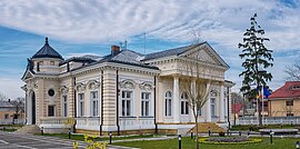 History Museum | |
 Coat of arms | |
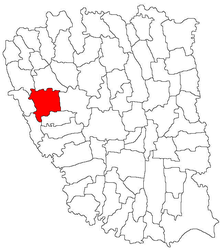 Location in Galați County | |
 Tecuci Location in Romania | |
| Coordinates: 45°50′48″N 27°25′40″E / 45.84667°N 27.42778°ECoordinates: 45°50′48″N 27°25′40″E / 45.84667°N 27.42778°E | |
| Country | Romania |
| County | Galați |
| Government | |
| • Mayor (2020–2024) | Lucian-Grigore Costin[1] (PNL) |
| Area | 86.76 km2 (33.50 sq mi) |
| Population (2011)[2] | 34,871 |
| • Density | 400/km2 (1,000/sq mi) |
| Time zone | EET/EEST (UTC+2/+3) |
| Vehicle reg. | GL |

Tecuci (Romanian pronunciation: [teˈkut͡ʃʲ]) is a city in Galați County, Romania, in the historical region of Western Moldavia. It is situated among wooded hills, on the right bank of the Bârlad River, and at the junction of railways from Galați, Bârlad, and Mărășești.
History[]
The area neighboring Tecuci was the scene of a fierce battle in 1476 between Moldavian Prince Stephen the Great and the Ottomans.[3]
Under the Kingdom of Romania, it was the residence of the now-defunct Tecuci County.[3]
Economy[]
The city was famous[when?] for its canned food factories, which preserve vegetables, fruit and meat, as well as for its mustard factories.
Climate[]
Climate in Tecuci is defined as Dfb (Humid continental climate with warm summers), bordering a Dfa (Humid continental climate with hot summers).
| Month | Jan | Feb | Mar | Apr | May | Jun | Jul | Aug | Sep | Oct | Nov | Dec | Year |
|---|---|---|---|---|---|---|---|---|---|---|---|---|---|
| Average high °C (°F) | 0.9 (33.6) |
2.9 (37.2) |
9.1 (48.4) |
16.7 (62.1) |
22.4 (72.3) |
25.8 (78.4) |
27.7 (81.9) |
27.4 (81.3) |
23.3 (73.9) |
16.7 (62.1) |
9.1 (48.4) |
3.2 (37.8) |
15.4 (59.8) |
| Daily mean °C (°F) | −2.5 (27.5) |
−0.6 (30.9) |
4.5 (40.1) |
11.0 (51.8) |
16.5 (61.7) |
19.9 (67.8) |
21.7 (71.1) |
21.3 (70.3) |
17.2 (63.0) |
11.2 (52.2) |
5.2 (41.4) |
0.2 (32.4) |
10.5 (50.8) |
| Average low °C (°F) | −5.9 (21.4) |
−4.0 (24.8) |
0.0 (32.0) |
5.4 (41.7) |
10.7 (51.3) |
14.1 (57.4) |
15.7 (60.3) |
15.2 (59.4) |
11.2 (52.2) |
5.8 (42.4) |
1.4 (34.5) |
−2.8 (27.0) |
5.6 (42.0) |
| Average precipitation mm (inches) | 27 (1.1) |
28 (1.1) |
27 (1.1) |
42 (1.7) |
59 (2.3) |
72 (2.8) |
59 (2.3) |
50 (2.0) |
44 (1.7) |
28 (1.1) |
33 (1.3) |
29 (1.1) |
498 (19.6) |
| Source: [4] | |||||||||||||
Population[]
| Year | Pop. | ±% |
|---|---|---|
| 1859 | 5,769 | — |
| 1900 | 13,401 | +132.3% |
| 1912 | 14,927 | +11.4% |
| 1930 | 17,172 | +15.0% |
| 1948 | 20,292 | +18.2% |
| 1956 | 23,400 | +15.3% |
| 1966 | 28,454 | +21.6% |
| 1977 | 36,143 | +27.0% |
| 1992 | 46,825 | +29.6% |
| 2002 | 42,012 | −10.3% |
| 2011 | 34,871 | −17.0% |
| Source: Census data | ||
As of 30 October 2011, 34,871 inhabitants live within the city limits.[5]
Natives[]
- Nina Arbore (1888–1942), painter and illustrator
- (1907–1978), historian
- Elena Caragiani-Stoenescu (1887–1929), first woman aviator in Romania
- Henri Cihoski (1872–1950), politician and general
- (1893–1976), jurist, lawyer and professor
- Alina Gorghiu (b. 1978), lawyer and former president of the National Liberal Party (PNL)
- Calistrat Hogaș (1847–1917), writer
- Iorgu Iordan (1888–1986), linguist, philologist and communist politician
- Mihail Manoilescu (1891–1950), publicist, economist and politician
- Henri Moscovici (b. 1944), mathematician
- Gheorghe Petrașcu (1872–1949), painter and academician
- N. Petrașcu (1859–1944), diplomat, writer, memoirist, publicist, art historian and critic
- Ion Petrovici (1882–1972), philosopher, essayist, memoirist, writer, orator and politician
- Theodor Șerbănescu (1839–1901), poet and translator
Museums[]
- Tecuci Town Museum (Romanian: Muzeul Mixt Tecuci)
References[]
| Wikimedia Commons has media related to Tecuci. |
- ^ "Results of the 2020 local elections". Central Electoral Bureau. Retrieved 8 June 2021.
- ^ "Populaţia stabilă pe judeţe, municipii, oraşe şi localităti componenete la RPL_2011" (in Romanian). National Institute of Statistics. Retrieved 4 February 2014.
- ^ Jump up to: a b Chisholm, Hugh, ed. (1911). . Encyclopædia Britannica (11th ed.). Cambridge University Press.
- ^ "Tecuci Climate". Climate-data.org. Retrieved November 25, 2016.
- ^ "Populaţia stabilă după etnie - judeţe, municipii, oraşe, comune". National Institute of Statistics. Retrieved April 15, 2014.

This Galați County location article is a stub. You can help Wikipedia by . |
- Tecuci
- Populated places in Galați County
- Cities in Romania
- Capitals of former Romanian counties
- Localities in Western Moldavia
- Galați County geography stubs