Tegermansu Pass
| Tegermansu Pass | |
|---|---|
 Kyrgyz camp near Tegermansu Pass as captured by Aurel Stein | |
| Elevation | 4,827 metres (15,837 ft) |
| Location | Badakhshan Province, Afghanistan Xinjiang, China |
| Coordinates | 37°13′26″N 74°52′26″E / 37.224°N 74.874°E |
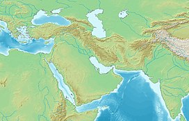 Location in Afghanistan | |


| Tegermansu Pass | |||||||
|---|---|---|---|---|---|---|---|
| Traditional Chinese | 托克滿蘇山口 | ||||||
| Simplified Chinese | 托克满苏山口 | ||||||
| |||||||
| Tok Man Su Daban | |||||||
| Traditional Chinese | 托克滿素達坂 | ||||||
| Simplified Chinese | 托克满素达坂 | ||||||
| |||||||
| Tigarman Su Pass | |||||||
| Traditional Chinese | 鐵蓋滿蘇山口 | ||||||
| Simplified Chinese | 铁盖满苏山口 | ||||||
| |||||||
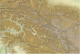
Tegermansu Pass or Tigarman Su Pass (Kotal-e Tegermansu, Chinese: 托克满苏山口[1]) is a closed mountain pass on the border between Afghanistan and China in the Hindu Kush or Pamirs mountain range.[2] It is located between the on the eastern end of the Little Pamir and Chalachigu Valley in Xinjiang, China. Historically, it was one of the three routes between China and Wakhan.[3]
On Chinese side, there is a Chinese border post in the valley below.[4] There have been proposals and plans by Kashgar regional government to open this pass as a port of entry for economic purposes since the 1990s.[5][6] However, this has yet to happen.

Stylized horse and bird, Tomb of Tegermansu I, Eastern Pamirs, Tajikistan, 4th century BCE
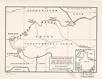
Map of Afghanistan-China Boundary including Tegermansu Pass (labeled as TĪGARMAN SŪ DAVĀN) (1969)[a]


See also[]
- Afghanistan-China border
- Wakhjir Pass
- Beyik Pass
- Kilik Pass
- Mintaka Pass
- China–Tajikistan border
- China–Pakistan border
Notes[]
- ^ From map: "NAMES AND BOUNDARY REPRESENTATION ARE NOT NECESSARILY AUTHORITATIVE"
References[]
- ^ [Afghanistan-China Border Agreement] (in Chinese). 1963-11-22 – via Wikisource.
托克满素达坂(阿方图称米赫满育里山口)...克克拉去考勒达坂(阿方图称铁盖满苏山口)
- ^ "Wakhan & the Afghan Pamir - In the footsteps of Marco Polo". Aga Khan Foundation. Jan 2010.
side trip to Tegermansu (3-4 days one way from Chaqmaqtin Lake) and Kotal-e Tegermansu (4872m) on Afghanistan-China border, easternmost area of Little Pamir. Warning: All passes leading into Tajikistan and China are strictly off-limits to foreigners
- ^ Malik, Hasan Yaser (2014). "Geo-political Significance of the Wakhan Corridor for China". Fudan Journal of the Humanities and Social Sciences. 7 (2): 307–323. doi:10.1007/s40647-014-0017-z. ISSN 1674-0750.
The narrow Wakhan Strip provides the following three routes -- The third one is the Central Route: linking both the Northern and Southern routes at Wakhan and further leading to China via Tegermansu Pass over a height of 4,827 m.
- ^ "蜀中行:"瓦罕走廊"传来重大消息,阿富汗向中国送上大礼!-中华必亮剑天天时事-中华必亮剑个人博客". m.bljcn.com (in Chinese). 2018-08-31. Retrieved 23 December 2019.
托克满苏边防站 如今的瓦罕走廊驻守着明铁盖边防7连、托克满苏边防8连、克克吐鲁克(科克吐鲁克)边防9连。
- ^ "新疆对外开放口岸一览表". china.com.cn (in Chinese). Retrieved 23 December 2019.
国别:阿富汗 口岸名称:托克满苏 开放时间:未定 说明:规划开放口岸(98年) Country: Afghanistan, Name of port: Tegermansu, Opening date: Undecided, Notes: Planning to open the port (1998)
- ^ 喀什地区发展和改革委员会 (Kashgar Region Development and Reform Committee) (2016-03-17). "喀什地区国民经济和社会发展第十三个五年" [Kashgar Regional Economic and Social Development 13th Five-Year Plan (2016-2020)]. Retrieved 23 December 2019.
推进新建中国-阿富汗托克满苏陆路口岸、中国-巴基斯坦铁路口岸、中国-塔吉克斯坦铁路口岸。改善现有口岸通关条件。
Mountain passes of China | |||||||||||||||
|---|---|---|---|---|---|---|---|---|---|---|---|---|---|---|---|
| On the border |
| ||||||||||||||
| In the interior |
| ||||||||||||||
| |||||||||||||||
This Xinjiang location article is a stub. You can help Wikipedia by . |
This Badakhshan Province, Afghanistan location article is a stub. You can help Wikipedia by . |
- Mountain passes of Afghanistan
- Mountain passes of Xinjiang
- Afghanistan–China border
- Mountain passes of the Pamir
- Xinjiang geography stubs
- Badakhshan Province geography stubs