Tengnoupal district
Tengnoupal district | |
|---|---|
District of Manipur | |
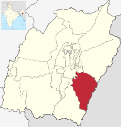 Location of Tengnoupal District in Manipur | |
| Country | |
| State | |
| Headquarters | Tengnoupal |
| Area | |
| • Total | 1,213 km2 (468 sq mi) |
| Population (2011) | |
| • Total | 59,110 |
| • Density | 49/km2 (130/sq mi) |
| Time zone | UTC+05:30 (IST) |
| Website | https://tengnoupal.nic.in/ |
Tengnoupal district is a new district in Manipur, India created by splitting the Chandel district. It is one of the 16 full fledged districts of the Indian state of Manipur.
The district headquarters has been relocated to Tengnoupal – (24°19′41″N 93°59′10″E / 24.328°N 93.986°ECoordinates: 24°19′41″N 93°59′10″E / 24.328°N 93.986°E). In the 1960s and 1970s, Tengnoupal was the District Headquarters, and it was shifted to Chandel in 1974. Tengnoupal district is geographically strategical for installation of many Government infrastructures.
 WikiMiniAtlas
Sub-divisions[]
The sub-divisions in Tengnoupal district are:
Demographics[]
References[]
- "7 new districts formed in Manipur amid opposition by Nagas". indiatoday.intoday.in. Retrieved 1 July 2017.
- "Manipur Creates 7 New Districts". NDTV.com. Retrieved 1 July 2017.
- Laithangbam, Iboyaima. "New districts to stay, says Manipur CM". The Hindu. Retrieved 1 July 2017.
- "Manipur Chief Minsiter [sic] inaugurates two new districts amid Naga protests - Times of India". The Times of India. Retrieved 1 July 2017.
- "Simply put: Seven new districts that set Manipur ablaze". The Indian Express. 20 December 2016. Retrieved 1 July 2017.
- "Creation of new districts could be game-changer in Manipur polls". www.hindustantimes.com/. 20 December 2016. Retrieved 1 July 2017.
External Links[]
Categories:
- Tengnoupal district
- Districts of Manipur
- Manipur geography stubs