Thathri
This article needs additional citations for verification. (May 2018) |
Thathri | |
|---|---|
Town / Tehsil | |
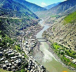 Thathri Town in 2018 | |
 Thathri Location in Jammu and Kashmir, India | |
| Coordinates: 33°08′43″N 75°47′28″E / 33.14528°N 75.79111°ECoordinates: 33°08′43″N 75°47′28″E / 33.14528°N 75.79111°E | |
| Country | India |
| Union Territory | Jammu and Kashmir |
| District | Doda |
| Named for | Thathrian |
| Area | |
| • Total | 1.50 km2 (0.58 sq mi) |
| Elevation | 662 m (2,172 ft) |
| Population (2011).[1] | |
| • Total | 59,955 |
| • Density | 40,000/km2 (100,000/sq mi) |
| • Male | 31,627 |
| • Female | 28,328 |
| Demonym(s) | Bhaderwahi, Kashmiri, Sarazi, Gojri, Bhalessi |
| Languages | |
| • Official Language | Urdu |
| • Spoken | Bhadarwahi, Kashmiri, Gujari, Urdu |
| Time zone | UTC+5:30 (IST) |
| PIN | 182203 |
| Vehicle registration | JK06 |
| Sub-divisional magistrate | Athar Amin Zargar[2] |
| DDC Member | Sandeep Singh Manhas (BJP)[3] |

Thathri is a town and a notified area committee in Doda district in the Indian union territory of Jammu and Kashmir.[4][5] Thathri valley is located in the foothills of the Himalayan mountains, about 85 km from Batote. Apart from having ample forests, the town contains many small streams flowing through its various parts. It is located on the banks of the famous Chenab River and the town area is spread over 1.50 sq. Km².[6]
Etymology[]
The word Thathri is derived from the Kashmiri word "Thath" (ٹہاٹھ) and according to some other historians, it is derived from the Hindi word "ठठेरा".
History[]


In ancient times, it was filled with the paddy fields of nearby villagers. As more and more people built their houses in place of these fields and finally it became a village. Over time, the population increased by people coming and settling here from nearby villages and also from places as far as Tral, Baramulla in Kashmir and the people who now settled in Thathri made it a center of business. The reasons for Kashmiri population settling here in the past in 17th or 18th century is matter of ambiguity between historians. However Sumantra Bose says it was repression by feudal class that drew people to the district of Doda.[7] In 2011 the population census reported that Thathri contained at least 93 villages. Thathri was formerly a part of Tehsil Bhadarwah, until it separated as a new Tehsil in 1981. In 2011 Thathri was upgraded to a town. On 23 July 2014 it was upgraded to Subdivision, and is now divided into five Tehsils as Thathri, Phagsoo, Kahara , Chiralla and Bhela. The first municipal elections of Thathri town were held in October 2018.
On 22 July 2017, a flash flood affected Thathri, killing 6 people and washing away 6 homes.[8]
Thathri town, the headquarters of Thathri tehsil, is an underdeveloping town in Doda district of Jammu and Kashmir as of 2019.[9]
Thathri is a historical and commercially important town in the Thathri subdivision. It is located along the left bank of Chenab river and National Highway 244 passes through the town.[citation needed]
Demand for district status[]
As of 2020, demand for district status in Thathri subdivision is increasing with number of arguments with the present district.[10]
Location[]
Thathri town is located in the foothills of the Lesser Himalayas, 34Km far from Doda city and 30Km from Kishtwar and Batote-Kishtwar National Highway 244 passes through the town.
Climate[]
| hideClimate data for Thathri, Jammu and Kashmir, India | |||||||||||||
|---|---|---|---|---|---|---|---|---|---|---|---|---|---|
| Month | Jan | Feb | Mar | Apr | May | Jun | Jul | Aug | Sep | Oct | Nov | Dec | Year |
| Average high °C (°F) | 7.6 (45.7) |
10.7 (51.3) |
16.1 (61.0) |
21.4 (70.5) |
25.5 (77.9) |
29.3 (84.7) |
30.4 (86.7) |
29.8 (85.6) |
27.8 (82.0) |
22.9 (73.2) |
16.3 (61.3) |
9.9 (49.8) |
20.6 (69.1) |
| Average low °C (°F) | −1.9 (28.6) |
0.7 (33.3) |
4.1 (39.4) |
7.8 (46.0) |
11.1 (52.0) |
15.2 (59.4) |
18.5 (65.3) |
17.6 (63.7) |
12.9 (55.2) |
6.1 (43.0) |
1 (34) |
−1.3 (29.7) |
7.7 (45.8) |
| Average precipitation mm (inches) | 11.8 (0.46) |
28.5 (1.12) |
39.6 (1.56) |
23.3 (0.92) |
21 (0.8) |
27.3 (1.07) |
29.3 (1.15) |
29.8 (1.17) |
2.5 (0.10) |
10.7 (0.42) |
9.4 (0.37) |
13.4 (0.53) |
246.6 (9.67) |
| Source: World Weather Online[11] | |||||||||||||
Demographics[]
The population of Thathri tehsil as of the 2011 census is 59,955, of which 31,627 are men and 28,328 are women, living in 6,797 households spread across a total of 93 villages and 33 panchayats.[12]
According to the 2011 census, the list of villages in Thathri along with their population is shown in the table below:[13]
| S. No. | Village | Administrative Division | Population |
|---|---|---|---|
| 1 | Agrika | Thathri | 100. |
| 2 | Amrit Garh | Thathri | 266. |
| 3 | Bachhra | Thathri | 205. |
| 4 | Bajah | Thathri | 567. |
| 5 | Banola | Thathri | 530. |
| 6 | Barshala | Thathri | 1,403. |
| 7 | Bathri | Thathri | 2,548 |
| 8 | Bhalara | Thathri | 708 |
| 9 | Bhatola | Kahara (Thathri) | 917 |
| 10 | Bhatoli | Thathri | 504 |
| 11 | Bhela | Thathri | 1,657 |
| 12 | Bolian | Thathri | 1,011 |
| 13 | Botagra | Thathri | 1,063 |
| 14 | Budhi | Thathri | 323 |
| 15 | Chagnu | Thathri | 269 |
| 16 | Chegsu | Thathri | 647 |
| 17 | Chira | Thathri | 542 |
| 18 | Chuteri | Thathri | 152 |
| 19 | Dadian | Thathri | 240 |
| 20 | DaronKerani | Thathri | 344 |
| 21 | Daronjamani | Thathri | 287 |
| 22 | Darori | Thathri | 101 |
| 23 | Dehra | Thathri | 200 |
| 24 | Deyoki | Thathri | 567 |
| 25 | Dhaliah | Thathri | 284 |
| 26 | DharYotha | Thathri | 2,096 |
| 27 | Dichhal | Thathri | 608 |
| 28 | Fagsu(Phagsoo) | Thathri | 2,709 |
| 29 | Galoo | Thathri | 399 |
| 30 | Ghaba | Thathri | 704 |
| 31 | Goela | Kahara (Thathri) | 803 |
| 32 | Gosti | Thathri | 1,017 |
| 33 | Grondra | Thathri | 261 |
| 34 | Gugara | Thathri | 731 |
| 35 | Gurekra | Thathri | 385 |
| 36 | Hagona | Thathri | 220 |
| 37 | Halaran | Kahara (Thathri) | 194 |
| 38 | Hanejo | Thathri | 196 |
| 39 | Herani | Thathri | 273 |
| 40 | HojaBola | Thathri | 673 |
| 41 | Indlu | Thathri | 411 |
| 42 | Indrala | Thathri | 868 |
| 43 | Jagota | Thathri | 406 |
| 44 | Jhandani | Thathri | 271 |
| 45 | Jangalwar | Thathri | 623 |
| 46 | Jasolah | Thathri | 122 |
| 47 | Jhajka | Thathri | 161 |
| 48 | Jia | Kahara (Thathri) | 190 |
| 49 | JoraKalan | Thathri | 939 |
| 50 | JoraKhurd | Thathri | 1,108 |
| 51 | KahiTrankal | Thathri | 1,049 |
| 52 | Kahla | Thathri | 333 |
| 53 | Kandote | Thathri | 990 |
| 54 | Kanso | Thathri | 475 |
| 55 | Kathawa | Thathri | 687 |
| 56 | Kawani | Thathri | 284 |
| 57 | Kemega | Thathri | 165 |
| 58 | Kencha | Kahara (Thathri) | 754 |
| 59 | Kolai | Thathri | 144 |
| 60 | KothiBala | Thathri | 173 |
| 61 | KothiPain | Thathri | 127 |
| 62 | Kundi | Thathri | 279 |
| 63 | Kuthiara | Thathri | 729 |
| 64 | Madren | Thathri | 75 |
| 65 | Mahri | Thathri | 272 |
| 66 | Malanu | Kahara (Thathri) | 553 |
| 67 | Malota | Thathri | 766 |
| 68 | Nagni | Thathri | 337 |
| 69 | Nai | Thathri | 230 |
| 70 | Nanadna | Thathri | 1,052 |
| 71 | Natwas | Thathri | 94 |
| 72 | Panthan | Thathri | 277 |
| 73 | Parnot | Thathri | 783 |
| 74 | Pemasa | Thathri | 562 |
| 75 | Piykal | Thathri | 448 |
| 76 | Puneja | Thathri | 1,167 |
| 77 | Ranote | Kahara (Thathri) | 371 |
| 78 | Renkha | Thathri | 350 |
| 79 | RukaliKalan | Thathri | 480 |
| 80 | RukaliKhurd | Thathri | 195 |
| 81 | Sahan | Thathri | 288 |
| 82 | Shahrote | Thathri | 598 |
| 83 | Shakla | Thathri | 81 |
| 84 | ShamDalain | Thathri | 328 |
| 85 | Sharni | Thathri | 357 |
| 86 | Shibnot | Thathri | 243 |
| 87 | Sichal | Kahara (Thathri) | 1,340 |
| 88 | Sunarthawa | Thathri | 938 |
| 89 | Suranga | Thathri | 502 |
| 90 | Tanta | Thathri | 2,324 |
| 91 | Thalela | Thathri | 2,014 |
| 92 | Thatri | Thathri | 4,938 |
| 93 | Garh | Badanoo (Thathri) | 61 |
Nearby villages[]
Thathri is the single town in Thathri subdivision of Doda district in the union territory of Jammu and Kashmir in India. It is the main town for the Thathri subdivision and also the Tehsil headquarters. Thathri village promoted as town in 2010. It is approximately 36 km from the district headquarters at Doda. Nearby villages include Zea Abad (0.05Km) Barshala (1.2 km),Sharote (2.5 km), Bagh(0.1 km). Drabshala (5.2 km), Tanta (10.5 km), Premnagar (12 km), and Bhatyass (15 km). The nearest towns are Doda (36 km), Bhaderwah (60 km), Bhalessa (Gandoh) (30.5 km) and Kishtwar (30.3 km).
Noon chai[]
Noon chai in kashmiri (commonly known in Hindi/Urdu as Namkeen Chai) or Pink Tea is a famous beverage of the people of Thathri. Villagers often start their workdays by sipping a cup of tea at their homes or hotels. Noon Chai (noon means salt, 'chai means tea) is eaten with traditional Kashmiri breads and pastries like lavasa, sheermaal, kandir chot, bakarkhani and kulcha. It is traditionally made from special tea leaves, milk, salt, and cooked in a samavar. A pinch of baking soda is added to help give it more of a pronounced pink color. A recent variant preparation of this tea also includes sugar but it is not traditionally consumed in Thathri.[14]
See also[]
References[]
| Look up thathri in Wiktionary, the free dictionary. |
- ^ "Thathri Tehsil Population, Caste, Religion Data - Doda district, Jammu and Kashmir".
- ^ Doda.nic.in Directory S.No 6
- ^ "BJP clears ex-Minister, MLA in 2nd list of 46 candidates". Daily Excelsior. 16 November 2020. Retrieved 3 January 2021.
- ^ Historical Origin Of District Doda Archived 15 February 2012 at the Wayback Machine
- ^ Location - Latitude and Longitude of Thathri.
- ^ Thathri Municipal Committee - Urban Local Bodies Jammu
- ^ Snedden, Christopher (2015), Understanding Kashmir and Kashmiris, Oxford University Press, p. 23, ISBN 978-1-84904-342-7
- ^ Thathri Floods - Times of India
- ^ "Thathri deserves district status, separate assembly constituency: TDF". State Times. 17 November 2019. Retrieved 21 July 2020.
- ^ Ayoob, Anzer (7 September 2020). "Why Thathri needs district status?". The Chenab Times. Retrieved 8 September 2020.
- ^ "Thathri, India Weather Averages - Monthly Average High and Low Temperature - Average Precipitation and Rainfall days". World Weather Online. Retrieved 20 June 2020.
- ^ "Thathri Tehsil Population, Caste, Religion Data - Doda district, Jammu and Kashmir".
- ^ Census 2011
- ^ Noon Chai - Famous tea in Thathri
- Cities and towns in Doda district
- Chenab Valley
- Doda district