The Mall, Lahore
Route map:

| Shahrah-e-Quaid-e-Azam شاہراہ قائد اعظم | |
|---|---|
| The Mall سڑک مال | |
| Route information | |
| Maintained by City District Government Lahore | |
| Length | 6.5 km (4.0 mi) |
| Existed | 2016–present |
| Major junctions | |
| From | |
| To | Mian Mir Bridge, Aziz Bhatti Road |
| Highway system | |
Shahrah-e-Quaid-e-Azam (Urdu: شاہراہ قائد اعظم), formerly known as The Mall or Mall Road (Urdu: سڑک مال, Sarak-e-Mall), is a major road in Lahore, Punjab, Pakistan.[1]
The road was laid out during the British Raj on a route leading to the Governor's House, lined on both sides with Mughal shrines and kilns.[2]
Attractions[]
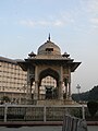
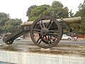
Places of historical, cultural and recreational significance on The Mall include:
- Amal Academy
- Aitchison College
- Alhamra Arts Council
- Avari Hotel
- Cathedral Church of Resurrection
- Qurban Lines (Police)
- Bagh-e-Jinnah (formerly Lawrence Gardens)
- Charing Cross
- Diyal Singh Mansion
- Ganga Ram Mansion
- Government College University
- Governor's House
- King Edward Medical College
- Lahore American School
- Lahore Museum
- Lahore Zoo
- Masonic Temple
- National College of Arts
- Pearl Continental Hotel
- Provincial Assembly of the Punjab
- Shah Din Manzil
- State Guest House
- Tollinton Market
- University of the Punjab
- Wapda House
- Zamzama Gun (also known as Kim's Gun)
Gallery[]
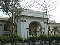
Masonic Temple

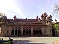
Lahore Museum

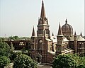
Government College University
Sacred Heart Cathedral

St. Anthony's College
Aitchison College

Ferozesons Books

Tollinton Market

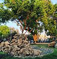
Bird Houses on Mall Road
Anarkali Stop


See also[]
- List of streets in Lahore
- Charing Cross
- Canal Bank Road
- Hall Road
References[]
- ^ Google maps. "Location of Mall Road". Google Maps. Retrieved 24 September 2013.
{{cite web}}:|last=has generic name (help) - ^ Jan Morris and Simon Winchester (2005). Stones of Empire: The Buildings of the Raj. Oxford University Press. pp. 203–205. ISBN 978-0-19-280596-6.
| Wikimedia Commons has media related to The Mall, Lahore. |
Categories:
- The Mall, Lahore
- Streets in Lahore
- Roads in Lahore