The Toe

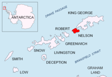
Location of Nelson Island in the South Shetland Islands.
The Toe is a point marking the south side of the entrance to Harmony Cove and the north-west side of the entrance to Varvara Cove on the west side of Nelson Island, in the South Shetland Islands. This descriptive name seems first to appear on a chart based upon a 1935 survey by DI personnel on the Discovery II. The Toe is part of both Antarctic Specially Protected Area Harmony Point (ASPA 133)[1] and the BirdLife International Important Bird Area Harmony Point, Nelson Island.[2]
Notes[]
- ^ Antarctic Specially Protected Area No 133 (Harmony Point, Nelson Island, South Shetland Islands): Revised Management Plan. Measure 7 (2012) ATCM XXXV - CEP XV. Hobart, 2012
- ^ Harmony Point, Nelson Island, BirdLife International Important Bird Area
References[]
![]() This article incorporates public domain material from the United States Geological Survey document: "The Toe". (content from the Geographic Names Information System)
This article incorporates public domain material from the United States Geological Survey document: "The Toe". (content from the Geographic Names Information System) ![]() Coordinates: 62°19′39.7″S 59°10′02″W / 62.327694°S 59.16722°W
Coordinates: 62°19′39.7″S 59°10′02″W / 62.327694°S 59.16722°W
Categories:
- Geography of Nelson Island (South Shetland Islands)
- Headlands of the South Shetland Islands
- South Shetland Islands geography stubs
