Thung Tako District
Thung Tako
ทุ่งตะโก | |
|---|---|
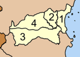
 District location in Chumphon Province | |
| Coordinates: 10°6′37″N 99°4′58″E / 10.11028°N 99.08278°ECoordinates: 10°6′37″N 99°4′58″E / 10.11028°N 99.08278°E | |
| Country | Thailand |
| Province | Chumphon |
| Seat | Thung Takhrai |
| Area | |
| • Total | 335.0 km2 (129.3 sq mi) |
| Population (2005) | |
| • Total | 23,535 |
| • Density | 70.3/km2 (182/sq mi) |
| Time zone | UTC+7 (ICT) |
| Postal code | 86220 |
| Geocode | 8608 |

Thung Tako (Thai: ทุ่งตะโก, pronounced [tʰûŋ tā.kōː]) is a district (amphoe) in the central part of Chumphon Province, southern Thailand.
Geography[]
Neighboring districts are (from the south clockwise) Lang Suan and Sawi of Chumphon Province. To the east is the Gulf of Thailand.
History[]
The minor districts (king amphoe) was created on 6 September 1976, when then three tambons Thung Takhrai, Tako, and Pak Tako were split off from Sawi District.[1] It was upgraded to a full district on 19 July 1991.[2]
Administration[]
The district is divided into four sub-districts (tambons), which are further subdivided into 35 villages (mubans). Pak Tako is a sub-district municipality (thesaban tambon) which covers the tambon of the same name. There are a further three tambon administrative organizations (TAO).
|
|
References[]
- ^ ประกาศกระทรวงมหาดไทย เรื่อง แบ่งท้องที่อำเภอสวี จังหวัดชุมพร ตั้งเป็นกิ่งอำเภอทุ่งตะโก (PDF). Royal Gazette (in Thai). 93 (106 ง Special): 16. August 27, 1976.
- ^ พระราชกฤษฎีกาตั้งอำเภอทุ่งตะโก อำเภอพะโต๊ะ อำเภอเขาค้อ อำเภอน้ำหนาว อำเภอวังจันทร์ อำเภอนาด้วง อำเภอเต่างอย อำเภอสิงหนคร อำเภอพระสมุทรเจดีย์ และอำเภอลำดวน พ.ศ. ๒๕๓๔ (PDF). Royal Gazette (in Thai). 108 (107 ก Special): 29–33. June 19, 1991.
External links[]
| Wikimedia Commons has media related to Thung Tako District. |
This Chumphon Province location article is a stub. You can help Wikipedia by . |
- Amphoe of Chumphon Province
- Southern Thailand geography stubs