Titteri
| Titteri | |
|---|---|
| Tittri / جبل التيطري | |
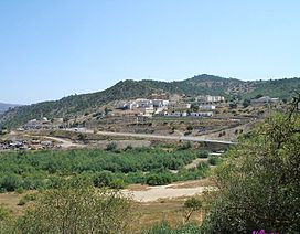 Landscape of the Mezghena commune in the Titteri, Médéa Province | |
| Highest point | |
| Peak | |
| Elevation | 1,485 m (4,872 ft) |
| Coordinates | 36°16′0″N 2°45′0″E / 36.26667°N 2.75000°ECoordinates: 36°16′0″N 2°45′0″E / 36.26667°N 2.75000°E[1] |
| Geography | |
 Titteri | |
| Parent range | Blidean Atlas |

The Titteri (Arabic: جبل التيطري, Berber languages: Tittri) is a historical region in Algeria.[2] It is located in the mountainous area of the southern Tell Atlas in the Atlas Mountains.
Geography[]
The Titteri was a former administrative division of the Regency of Algiers. It is located in the area of Médéa, stretching across parts of Aïn Defla, Bouïra, Djelfa and M'Sila Province as well. Its northern zone corresponds to the southern slopes of the and its southern part reaches the western Bibans. The climate of the area is semi-arid.[3][4]
The highest summit of the range is 1,485 m high (جبل ديرة). Other notable peaks of the Titteri are 1,423 m high Djebel Guern el-Adhaoura (جبل قرن العذاورة), 1,416 m high Djebel Kef Lakhdar (جبل الكاف الأخضر) and 1,400 m high Kef Afoul (جبل كاف آفول).
The main human groups inhabiting the Titteri area were mainly the Aït Ouzera, the Aït Bou Yaagoub and the Aït Slimane, who spoke the Blidean Atlas variant of the Tamazight language. Beekeeping and cattle-rearing were some of the traditional activities of the region.
See also[]
References[]
External links[]
 Media related to Titteri at Wikimedia Commons
- Carte des tribus du titteri - 1846 - Algérie (Old map of the Titteri)
- Recette de Mekhtouma , Spécialité : Titteri, Algérie
- Recette de Tchakhtchoukhet Lessyed , Spécialité : Titteri, Algérie by Samira tv
| Tell Atlas |
|
|---|---|
| Saharan Atlas | |
| Saharan massifs |
|
| Peaks | |
This article about a location in Médéa Province is a stub. You can help Wikipedia by . |
- Mountains of Algeria
- Geography of Médéa Province
- Historical regions
- Médéa Province geography stubs