Tolú
This article contains content that is written like an advertisement. (September 2015) |
Tolú
Tolú | |
|---|---|
Municipality and town | |
 | |
 Flag  Seal | |
 Location of the municipality and town of Tolú in the Sucre Department of Colombia. | |
| Country | |
| Department | Sucre Department |
| Area | |
| • Municipality and town | 301.22 km2 (116.30 sq mi) |
| Elevation | 2 m (7 ft) |
| Population (2015) | |
| • Municipality and town | 33,296 |
| • Urban | 27,290 |
| Time zone | UTC-5 (Colombia Standard Time) |
Tolú is a small municipality and town in Sucre Department, northern Colombia by the Caribbean sea. The municipality has an area of 500 km². It is named for , one the pre-Columbian indigenous people of the North Colombia lowlands.[1]
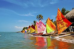
Tolú offers ecotourism ideal for diving and rain forest treks.
The fishing town has now become a popular weekend and holiday destination for Colombian tourists, particularly those from Medellín. Activities in the area include day trips to visit the Archipelago de San Bernardo. This is a beautiful collection of pristine Caribbean islands, one of which, Isla Palma contains an impressive Ecological Park. Nearby land attractions include the Volcan de Lodo or
Tolú is a word that comes from the name of the Indians that inhabited the place, called Tolúes.
The municipality of Tolú borders North with San Onofre, East with Toluviejo, South with Coveñas, Palmito and Sincelejo.
Notable people[]
- Héctor Rojas Herazo (1920–2002), novelist, poet and painter
- José Gonzalo Rodríguez Gacha (1947-1989) , drug dealer, part of Medellin Cartel
See also[]
References[]
- ^ Julian H. Steward, ed. (1948), Handbook of South American Indians, 4, U.S. Government Printing Office, pp. 329–338
External links[]
- (in Spanish) Gobernacion de Sucre - Tolú
- (in Spanish) ToluCaribe.com - Recreación, Historia y Cultura de Tolú.
Coordinates: 9°32′N 75°35′W / 9.533°N 75.583°W

| show Municipalities in Sucre Department |
|---|
| show Authority control |
|---|
This Sucre Department location article is a stub. You can help Wikipedia by . |
- Port cities in the Caribbean
- Municipalities of Sucre Department
- Caribbean Region (Colombia) geography stubs