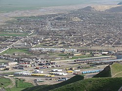
Torghundi
Torghundi
تورغونډۍ | |
|---|---|
 Torghundi | |
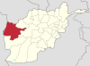
 Torghundi Location in Afghanistan | |
| Coordinates: 35°15′N 62°17′E / 35.250°N 62.283°E | |
| Country | |
| Province | Herat Province |
| District | Kushk District |
| Elevation | 2,224 ft (678 m) |
| Time zone | UTC+4:30 |
| Control | |

Torghundi, also spelled Turghundi or Towrgondi (Pashto: تورغونډۍ, Tōrghūnḍəi), is a border town in northern Herat province of Afghanistan. It is the second border crossing between Afghanistan and neighboring Turkmenistan (Aqina is the other). The town of Serhetabat in Turkmenistan is located just a short drive from the border crossing. Torghundi is about 100 km from the city of Herat.
Torghundi is connected by a road and a 1520 mm gauge railroad with Serhetabat. The railroad was originally built in 1960 as a single track,[citation needed] and was upgraded in 2017.[1][2] Torghundi has become the starting point of the Lapis Lazuli trade corridor.
In July 2021 Torghundi and its border crossing between Turkmenistan and Afghanistan was captured by Taliban fighters, as part of the wider 2021 Taliban offensive.[3]
Climate[]
With an influence from the local steppe climate, Torghundi features a cold semi-arid climate (BSk) under the Köppen climate classification. The average temperature in Toraghundi is 15.8 °C, while the annual precipitation averages 300 mm.
July is the hottest month of the year with an average temperature of 28.5 °C. The coldest month January has an average temperature of 3.4 °C.
| hideClimate data for Torghundi | |||||||||||||
|---|---|---|---|---|---|---|---|---|---|---|---|---|---|
| Month | Jan | Feb | Mar | Apr | May | Jun | Jul | Aug | Sep | Oct | Nov | Dec | Year |
| Average high °C (°F) | 9.0 (48.2) |
10.4 (50.7) |
16.4 (61.5) |
22.5 (72.5) |
29.4 (84.9) |
34.6 (94.3) |
36.7 (98.1) |
35.1 (95.2) |
30.8 (87.4) |
24.8 (76.6) |
17.3 (63.1) |
11.6 (52.9) |
23.2 (73.8) |
| Daily mean °C (°F) | 3.4 (38.1) |
4.8 (40.6) |
10.0 (50.0) |
15.5 (59.9) |
21.2 (70.2) |
26.0 (78.8) |
28.5 (83.3) |
26.8 (80.2) |
21.7 (71.1) |
16.0 (60.8) |
9.7 (49.5) |
5.5 (41.9) |
15.8 (60.4) |
| Average low °C (°F) | −2.2 (28.0) |
−0.7 (30.7) |
3.7 (38.7) |
8.6 (47.5) |
13.0 (55.4) |
17.4 (63.3) |
20.4 (68.7) |
18.5 (65.3) |
12.7 (54.9) |
7.3 (45.1) |
2.2 (36.0) |
−0.5 (31.1) |
8.4 (47.1) |
| Source: Climate-Data.org[4] | |||||||||||||
See also[]
- Turkmenistan–Afghanistan–Pakistan–India Pipeline (TAPI)
- Afghanistan–Turkmenistan relations
- Aqina (second border crossing between Afghanistan and Turkmenistan)
- Islam Qala
- Hairatan
- Sher Khan Bandar
- Demogan
- Spin Boldak
- Torkham
References[]
- ^ Kakar, Javed Hamim (1 December 2017). "Construction of Turkmen-Afghan railroad begins". Pajhwok Afghan News. Retrieved 7 December 2017.
- ^ "Великий Шёлковый путь, пролегавший в древности по территории Туркменистана, получает новое воплощение". State Information Agency of Turkmenistan. 8 December 2017. Retrieved 12 December 2017.
- ^ "Taliban capture key Afghanistan border crossings". BBC News. 9 July 2021. Archived from the original on 9 July 2021. Retrieved 10 July 2021.
- ^ "Climate: Towrgondi - Climate-Data.org". Retrieved 9 September 2016.
Coordinates: 35°15′N 62°17′E / 35.250°N 62.283°E
This Herat Province, Afghanistan location article is a stub. You can help Wikipedia by . |
- Populated places in Herat Province
- Afghanistan–Turkmenistan border crossings
- Afghanistan geography stubs