Tornadogenesis


Tornadogenesis is the process by which a tornado forms. There are many types of tornadoes and these vary in methods of formation. Despite ongoing scientific study and high-profile research projects such as VORTEX, tornadogenesis is a volatile process and the intricacies of many of the mechanisms of tornado formation are still poorly understood.[1][2][3]
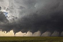
A tornado is a violently rotating column of air in contact with the surface and a cumuliform cloud base. Tornado formation is caused by the stretching of environmental and/or storm-induced vorticity that tightens it into an intense vortex. There are various ways this may come about and thus various forms and sub-forms of tornadoes. Although each tornado is unique, most kinds of tornadoes go through a life cycle of formation, maturation, and dissipation.[4] The process by which a tornado dissipates or decays, occasionally conjured as tornadolysis, is of particular interest for study as is tornadogenesis, longevity, and intensity.
Mesocyclones[]
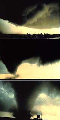
Classical tornadoes are supercellular tornadoes, which have a recognizable pattern of formation.[5] The cycle begins when a strong thunderstorm develops a rotating mesocyclone a few miles up in the atmosphere. As rainfall in the storm increases, it drags with it an area of quickly descending air known as the rear flank downdraft (RFD). This downdraft accelerates as it approaches the ground, and drags the rotating mesocyclone towards the ground with it. Storm relative helicity (SRH) has been shown to play a role in tornado development and strength. SRH is horizontal vorticity that is parallel to the inflow of the storm and is tilted upwards when it is taken up by the updraft, thus creating vertical vorticity.
As the mesocyclone lowers below the cloud base, it begins to take in cool, moist air from the downdraft region of the storm. This convergence of warm air in the updraft, and this cool air, causes a rotating wall cloud to form. The RFD also focuses the mesocyclone's base, causing it to siphon air from a smaller and smaller area on the ground. As the updraft intensifies, it creates an area of low pressure at the surface. This pulls the focused mesocyclone down, in the form of a visible condensation funnel. As the funnel descends, the RFD also reaches the ground, creating a gust front that can cause severe damage a good distance from the tornado. Usually, the funnel cloud begins causing damage on the ground (becoming a tornado) within a few minutes of the RFD reaching the ground.[citation needed]
Field studies have shown that in order for a supercell to produce a tornado the RFD needs to be no more than a few Kelvin cooler than the updraft. Also the FFD (forward flank downdraft) seems to be warmer within tornadic supercells than in non-tornadic supercells.[citation needed]
Although many envision a top-down process in which a mid-level mesocyclone first forms and couples with a low-level mesocyclone or tornadocyclone and a vortex then forms below the cloud base and becomes a concentrated vortex due to convergence upon reaching the surface, it has long been observed and there is now more rapidly growing evidence that many tornadoes form first near the surface or simultaneously from the surface to low and mid levels aloft.[6][7]
Misocyclones[]
Waterspouts[]
Waterspouts are defined as tornadoes over water. However, while some waterspouts are supercellular (also known as "tornadic waterspouts"), forming in a process similar to that of their land-based counterparts, most are much weaker and caused by different processes of atmospheric dynamics. They normally develop in moisture-laden environments with little vertical wind shear in areas where wind comes together (convergence), such as land breezes, lake effect bands, lines of frictional convergence from nearby landmasses, or surface troughs. Waterspouts normally develop as their parent clouds are in the process of development. It is theorized that they spin upward as they move up the surface boundary from the horizontal shear near the surface, and then stretch upward to the cloud once the low level shear vortex aligns with a developing cumulus or thunderstorm.[8] Their parent cloud can be as innocuous as a moderate cumulus, or as significant as a supercell.
Landspouts[]
Landspouts are tornadoes that do not form from supercells and are similar in appearance and structure to fair-weather waterspouts with the exception that they form over land instead of water. They are thought to form in a manner similar to that of weaker waterspouts[9] in that they form during the growth stage of convective clouds by the ingestion and tightening of boundary layer vorticity by the cumuliform tower's updraft.
Mesovortices[]
QLCS[]
Tornadoes sometimes form with mesovortices within squall lines (QLCS, quasi-linear convective systems), most often in middle latitudes regions. Mesocyclonic tornadoes may also form with embedded supercells within squall lines.
Tropical cyclones[]
Mesovortices or mini-swirls within intense tropical cyclones, particularly within eyewalls, may lead to tornadoes. Embedded supercells may produce mesocyclonic tornadoes in the right front quadrant or particularly in certain situations with outer rainbands.
Fire whirls and pyro-tornadogenesis[]
Most fire or volcanic eruption induced whirlwinds are not tornadic vortices, however, on rare occasion circulations with large wildfires, conflagrations, or ejecta do reach an ambient cloud base, and in extremely rare cases pyrocumulonimbus with tornadic mesocyclones have been observed.
See also[]
References[]
- ^ Coffer, Brice E.; M. D. Parker (2017). "Volatility of Tornadogenesis: An Ensemble of Simulated Nontornadic and Tornadic Supercells in VORTEX2 Environments". Mon. Wea. Rev. 145 (11): 4605–4625. Bibcode:2017MWRv..145.4605C. doi:10.1175/MWR-D-17-0152.1.
- ^ Trapp, R. Jeffrey; R. Davies-Jones (1997). "Tornadogenesis with and without a Dynamic Pipe Effect". J. Atmos. Sci. 54 (1): 113–133. Bibcode:1997JAtS...54..113T. doi:10.1175/1520-0469(1997)054<0113:TWAWAD>2.0.CO;2.
- ^ Davies-Jones, Robert (28 January 2006). "Tornadogenesis in supercell storms: What We Know and What We Don't Know". Symposium on the Challenges of Severe Convective Storms. Atlanta, GA: American Meteorological Society.
- ^ French, Michael M.; D. M. Kingfield (2019). "Dissipation Characteristics of Tornadic Vortex Signatures Associated with Long-Duration Tornadoes". J. Appl. Meteorol. Climatol. 58 (2): 317–339. Bibcode:2019JApMC..58..317F. doi:10.1175/JAMC-D-18-0187.1.
- ^ Doswell, Moller, Anderson; et al. (2005). "Advanced Spotters' Field Guide" (PDF). US Department of Commerce. Archived from the original (PDF) on 2006-08-23. Retrieved 2006-09-20. External link in
|publisher=(help)CS1 maint: multiple names: authors list (link) - ^ Jana, Houser; H. Bluestein; A. Seimon; J. Snyder; K. Thiem (Dec 2018). "Rapid-Scan Mobile Radar Observations of Tornadogenesis". AGU Fall Meeting. Washington, DC: American Geophysical Union.
- ^ Trapp, R. J.; E. D. Mitchell (1999). "Descending and Nondescending Tornadic Vortex Signatures Detected by WSR-88Ds". Wea. Forecasting. 14 (5): 625–639. Bibcode:1999WtFor..14..625T. doi:10.1175/1520-0434(1999)014<0625:DANTVS>2.0.CO;2.
- ^ Barry K. Choy and Scott M. Spratt. Using the WSR-88D to Predict East Central Florida Waterspouts. Retrieved on 2006-10-25.
- ^ National Weather Service (June 30, 2017). "EF-0 Landspout Tornado near Grand Junction, MI, on June 30, 2017". Retrieved 20 March 2018.
Further reading[]
- Markowski, Paul M.; Y.P. Richardson (Jul 2009). "Tornadogenesis: Our current understanding, forecasting considerations, and questions to guide future research" (PDF). Atmos. Res. 93 (1–3): 3–10. Bibcode:2009AtmRe..93....3M. doi:10.1016/j.atmosres.2008.09.015.
- Davies-Jones, Robert (2015). "A review of supercell and tornado dynamics". Atmos. Res. 158–159: 274–291. Bibcode:2015AtmRe.158..274D. doi:10.1016/j.atmosres.2014.04.007.
External links[]
- Markowski, Paul; Y. Richardson (2014). "What We Know and Don't Know About Tornado Formation". Phys. Today. 67 (9): 26–31. Bibcode:2014PhT....67i..26M. doi:10.1063/PT.3.2514.
- Markowski, Paul; Yvette Richardson (July–August 2013). "How to Make a Tornado" (PDF). Weatherwise. 66 (4): 12–19. doi:10.1080/00431672.2013.800413. S2CID 191649696.
- Tornadogenesis in Supercells: The Three Main Ingredients (NWS)
- Rasmussen, Erik; J. Straka; K. Kanak; et al. (2009). "Tornadogenesis: Unknowns. What's Left to Learn About Tornadoes?" (ppt). Rasmussen Systems. Retrieved 2012-02-14.[permanent dead link]
- Tornadogenesis research by Erik Rasmussen et al and Paul Markowski et al, also Josh Wurman et al
- Dr. Leigh Orf's Simulation and visualization of thunderstorms, tornadoes, and downbursts
- Tornadogenesis
- Tornado