Torreglia
show This article may be expanded with text translated from the corresponding article in Italian. (June 2012) Click [show] for important translation instructions. |
Torreglia | |
|---|---|
| Comune di Torreglia | |
show Location of Torreglia | |
 Torreglia Location of Torreglia in Italy | |
| Coordinates: 45°20′N 11°44′E / 45.333°N 11.733°ECoordinates: 45°20′N 11°44′E / 45.333°N 11.733°E | |
| Country | Italy |
| Region | Veneto |
| Province | Province of Padua (PD) |
| Government | |
| • Mayor | Filippo Legnaro (Lista Civica) |
| Area | |
| • Total | 18.8 km2 (7.3 sq mi) |
| Elevation | 23 m (75 ft) |
| Population (Dec. 2004)[2] | |
| • Total | 5,978 |
| • Density | 320/km2 (820/sq mi) |
| Time zone | UTC+1 (CET) |
| • Summer (DST) | UTC+2 (CEST) |
| Postal code | 35038 |
| Dialing code | 049 |
| Patron saint | Sacro Cuore di Gesù |
| Saint day | Friday after the Corpus Christi |


Torreglia is a comune (municipality) in the Province of Padua in the Italian Veneto region, located about 45 kilometres (28 mi) west of Venice and about 14 kilometres (9 mi) southwest of Padua. As of 31 December 2004, it had a population of 5,978 and an area of 18.8 square kilometres (7.3 sq mi).[3]
Torreglia borders the following municipalities: Abano Terme, Galzignano Terme, Montegrotto Terme, Teolo. The 16th century Villa dei Vescovi, Luvigliano is located in this territory.
Demographic evolution[]

References[]
- ^ "Superficie di Comuni Province e Regioni italiane al 9 ottobre 2011". Istat. Retrieved 16 March 2019.
- ^ "Popolazione Residente al 1° Gennaio 2018". Istat. Retrieved 16 March 2019.
- ^ All demographics and other statistics: Italian statistical institute Istat.
Gallery[]

Torreglia (Veneto/Italy), seen from Torreglia Alta
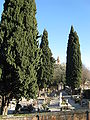
Cemetery and Church
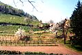
Almonds in flower

Calcina River

San Sabino Church

Torreglian sunset


| Authority control |
|---|
This article on a location in Veneto is a stub. You can help Wikipedia by . |
Categories:
- Cities and towns in Veneto
- Municipalities of the Province of Padua
- Veneto geography stubs