Transport in Leeds

Transport within Leeds consists of extensive road, bus and rail networks. The city has good rail and road links to the rest of the country. Leeds railway station is one of the busiest in Britain, and Leeds is connected to the national road network via the A1(M) motorway, M1 motorway and M62 motorway. The city is served by Leeds Bradford Airport.
Leeds has less extensive public transport coverage than other UK cities of comparable size, and is the largest city in Europe without any form of light rail or underground.[1]
Rail[]
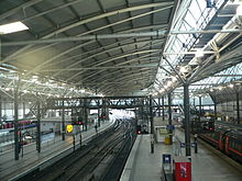
The rail network is of great importance. Leeds railway station on New Station Street is one of the busiest in the UK outside central London, with around 1,000 trains serving more than 100,000 passengers who pass through the main ticket gates daily.[2] Its modern interior provides connections to Birmingham, Bristol, Exeter, Newcastle via CrossCountry. Edinburgh and the north can be accessed via CrossCountry or London North Eastern Railway services to Aberdeen, although changes are often required at York or Newcastle. Manchester, Liverpool and the west are accessible by TransPennine Express, as are Scarborough and Hull in the east. There is a large commuter rail network co-ordinated by Metro and operated by Northern to many villages, towns and cities in the city region.
The station has 17 platforms, making it the largest in England outside London, and the second largest, after Edinburgh Waverley, in the UK, having been rebuilt from 12 platforms in 2001 at a cost of £265 million.
From Leeds, West Yorkshire Metro trains operated by Northern operate to all parts of West Yorkshire and surrounding local and commuter locations and other operators including CrossCountry, East Midlands Railway, London North Eastern Railway and TransPennine Express operate services to the rest of the country.
Leeds has two railway lines offering direct services to London. The principal route is along the electrified East Coast Main Line which operates half-hourly through the day. This service terminates at London Kings Cross. East Midlands Railway operate limited services via the Midland Main Line to London St Pancras, principally to facilitate the servicing of its High Speed Trains at Neville Hill TMD in Leeds.

Railway stations in Leeds[]
Closed railway stations[]
- Marsh Lane
- Leeds Wellington
- Leeds New
- Leeds Whitehall
- Leeds Central
- Newlay
- Kirkstall
- Hunslet Station
- Hunslet Lane
- Holbeck
- Armley Moor
- Armley Canal Road
- Beeston
- Pendas Way
- Scholes
- Kippax
- Otley
- Pool-in-Wharfedale
- Arthington
- Stanningley
- Pudsey Lowtown
- Pudsey Greenside
- Calverley
High Speed rail and Leeds New Lane[]
Publication of the proposed route of the second phase of High Speed 2 on 28 January 2013 revealed that the station at Leeds would be a new terminus called Leeds New Lane, connected to Leeds station by pedestrian walkways, possibly with moving walkways.[3] However, following a review in November 2015, there have also been proposals to instead add the HS2 platforms as an extension to the existing Leeds station.[4]
Middleton Steam Railway[]
The Middleton Steam Railway is the oldest continuously working railway system in the world. Originally built to transport coal from Middleton Colliery to Leeds, the railway is now a heritage piece. The railway effectively runs the length of Middleton Park, joining onto the national rail network at the northern end. The Middleton Steam Railway contains Leeds' only road level crossings (Moor Road and Tulip Street, Hunslet). There are two stations, Park Halt and Moor Road. The steam locomotives for the Middleton railway were made in Holbeck, near to the location of the present Leeds railway station.
Abbey Light Railway[]
The Abbey Light Railway was a narrow gauge railway in Kirkstall, Leeds. It ran between Bridge Street and Kirkstall Abbey, but was dismantled in March 2013, after the owner, Peter Lowe, died in October 2012.[5]
Roads[]
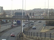
Leeds is the focus of the regional primary road network which includes A58, A61, A62, A63, A64 and A65 roads. It is also a principal hub of the national motorway network, with the M1 and M62 intersecting in the south east of the city and the A1(M) running along its eastern border. The M1 joins the A1(M) in east Leeds, creating a semi-orbital motorway consisting of the M62, M1 and A1(M) motorways around the south and east of the city. The M621 carries high volumes of traffic quickly in and out of central Leeds from the M62 and M1.
The Inner Ring Road largely carries through traffic across the city, whereas the City Centre Loop distributes local traffic around the city centre. The City Centre Loop that has been formed by using a number of existing streets to create a one way loop around the city centre. This acts as a local access thoroughfare for city centre traffic, allowing the core centre to be heavily pedestrianised and largely traffic-free.
Leeds will introduce a Clean Air Zone in 2020, which will charge the most polluting buses, coaches HGVs £50 a day to enter the city, while taxis and private hire vehicles which are not clean enough will be charged £12.50 a day. The proposals came after the government ordered the council to come up with ways to lower the air pollution in the city, which causes around 29,000 premature deaths in the UK.[6]
Inner Ring Road[]

In the 1960s Leeds set about building the most ambitious ring road plan of any British city. The road is designated as a motorway, and describes a semicircle round the western, northern and eastern parts of the city centre. The road is elevated at its western and eastern ends but in cutting and tunnel to the north. This enabled a long stretch to be hidden underground, reducing the scar it makes in the city's fabric (as has been a problem in many other cities, for example Birmingham and Leicester). Pedestrians may walk over it into the city centre, completely unaware of its presence. This gave Leeds City Council the idea to promote the city with the slogan Motorway City of the Seventies. The inner ring road is made up of the A58(M) and the A64(M). The road begins as the A58(M), at the Armley Gyratory and ends as the A64(M) at Quarry Hill (the number changes as the A58 forks off to the north at Clay Pit Lane).
The A64(M) continues east as graded dual carriageway with a mix of grade separated and traffic light controlled junctions. The Inner Ring Road junctions off and heads southwards towards the East Bank. Here, it meets the , which provides fast connections to the M1 northbound. It continues over the River Aire as a high quality dual carriageway on a flyover, meeting the M621 at Junction 4. The M621 completes the southern flank of the Inner Ring Road, linking up to the A643 which joins back to the Armley Gyratory.
City centre loop[]

To ease traffic in the city centre and to provide an efficient traffic distributor around the city, in particular where the Inner Ring Road does not help, the city centre loop was created. This involved no actual engineering or construction work, but the remaking of the city's entire one way system. One of the main advantages of the loop is its simplicity: whereas in other cities unfamiliar drivers may have to plan a route across the city's one way system or have to attempt map reading while driving, perhaps missing lanes and turnings, in Leeds the main body of city centre traffic is carried around the loop in a clockwise direction, and drivers can simply follow the signs and use the convenient junction numbers. However the city centre loop is less useful for drivers wishing to travel in an anti-clockwise direction. All loop signage is marked with the city centre loop logo, and each junction has a number and a name. The city centre loop connects the A58, A61, A64, A660, A65, A653 and A62 as well as smaller local routes. The route runs by Leeds railway station, the Merrion Centre, Quarry House, and Leeds General Infirmary as well as through the heart of the city's financial district.
Motorways and A roads[]
Leeds is served by the M1 and A1 heading South towards London and the East Midlands, the A1(M) heading north towards Newcastle upon Tyne and Edinburgh, the M62 heading both west towards Bradford, Manchester, Liverpool and the M62 and east towards Kingston upon Hull and the Port of Hull (this is a particularly important freight route).
Away from motorways, a regional dual carriageway network meets in Leeds. The A64 is an important trunk road, heading as an unbroken dual carriageway to the outskirts of York and then on to Scarborough. Added to this, the A61 expressway to the north links the northern suburbs of Leeds to the city centre, and onto Harrogate and Ripon. The A660 and A65 dual carriageways link the commuter belts to the north west of the city and onto the Lancashire, meeting the A650. The A6110 expressway forms part of the Leeds Outer Ring Road and continues as dual carriageway southwards, connecting the areas south of the M62 to Leeds. The Outer Ring Road is designated as A6120 in the north of the city. To the north east of the city, the East Leeds Orbital Route being constructed by Balfour Beatty will take the Outer Ring Road away from existing residential areas and facilitate development of land as part of an East Leeds Extension project.[7] Guided bus routes using kerb guidance operate on parts of the A61 (Scott Hall Road) and A64 (York Road).
The M621 is an internal urban motorway. Much of it is the former M1 (until it was diverted as the South East Leeds Orbital linking the M1 and A1(M)). The motorway begins at the M62 in Birstall, (near Ikea), and finishes where it merges with the M1 at Stourton. Since the M1 diversion the motorway has increased in length, previously it only ran from Birstall as far as the city centre. The M62 and M1 collectively create a part-orbital motorway around the south and east of the city.
Bus/coach/taxi[]


On 30 January 2006, the zero-fare FreeCityBus started running, on a circular route (including stops at the bus and railway stations), in the centre of Leeds.
Leeds City bus station, on Dyer Street is served by long distance Megabus and National Express services and local bus services. Buses in the city are mainly provided by Arriva Yorkshire and First West Yorkshire.
Harrogate Bus Company provides a service to Harrogate and Ripon, Keighley Bus Company provides a service to Shipley, Bingley and Keighley and the Yorkshire Coastliner service runs to Pickering, Scarborough, Filey, Thornton-le-Dale, Whitby and Bridlington via Tadcaster, York and Malton. Stagecoach in Hull operates a service to via Goole, while Stagecoach Yorkshire operates to Barnsley.
The 26 stand bus station[8] has become a controversy in the city.[citation needed] One of the main reasons is its distance from the railway station (about half a mile). Many First Leeds buses do not use the station, only external buses and National Express coaches use the station. Hence Eastgate, The Headrow, Park Row, Boar Lane, Vicar Lane, Albion Street and Cookridge Street are lined with bus stops. There are four smaller bus points in the city centre, one at the Leeds Corn Exchange,[9] one to the rear of the Leeds Shopping Plaza on Boar Lane,[10] one on Infirmary Street[11] and one outside the main entrance to the railway station for services linking the railway station with the rest of the city's public transport.[12]
The railway station has a dedicated public hire taxi rank that operates 24 hours a day. The rank is serviced by the whole Leeds fleet of 537 taxis, 237 of which are wheelchair accessible. All are fitted with a taxi meter set to Leeds City Council's fare tariff. All drivers are knowledge tested and have undergone criminal records investigations.[citation needed] The bus and coach station also has a dedicated rank which is located just outside near the Millgarth police station. All vehicles, drivers, and operators of both taxis and private hire vehicles must be licensed by the Council.[13]
Cycling[]
There is no integrated cycle network, nor is there a bicycle-sharing system. In 2010 Leeds Cyclepoint opened at Leeds railway station providing cycle hire by the day as well as paid secure parking for up to 300 cycles.[14] The council provide maps showing ideal road routes for cyclists cycling maps. The Leeds Cycling Campaign works with the council and campaigns for improved cycling provision.
In late 2014 work started on City Connect, which includes a mostly segregated cycle path connecting south Leeds and Bradford, as well as resurfacing parts of the Leed-Liverpool Canal shared use tow path. The project has been controversial due to the poorly laid surface by the contractor, Kier, as well as safety concerns surrounding the junctions where motorised traffic comes into contact with the segregated facility.
Before the 2014 Tour de France the number of publicly available bike lock-up rack has been increased, which includes high capacity racks in the shapes of cars.
Trams and trolleybus[]
Former system[]

Leeds' tram system was dismantled in the early 1950s (as was the case in most cities) with the final services running in November 1959.[15] In recent years this decision has become regarded as short-sighted. The former tram routes are evident on some of the main roads in and out of the city; for instance the void in the A64 York Road, now filled with guided bus lanes, and the unusually wide central reservation between the carriageways on the A58 Easterly Road (towards Wetherby). The original tram system ran a larger route than the proposed supertram; the original system ran along the A64, A58, A61, A660 and also down through Beeston and Belle Isle. By the time the tram network was dismantled it had become unpopular with many people in Leeds, due to its ageing, draughty and poorly maintained fleet.[citation needed] Neighbouring Bradford lost its trolley bus system during the same era (the final journey being made in 1972). Sheffield also lost its tram system several years earlier, yet has seen the return of the tram in the early 1990s.
Rejected plans[]
The city had plans in the 1990s and 2000s for a tram network known as Supertram. However the government axed the scheme due to an unwillingness to pay for any costs over budget, despite an undertaking by the City Council and local businesses to underwrite any such additional costs and the Department for Transport's apparent preference of a bus-based rapid transport scheme to a tram-based scheme. An inquiry into corruption at the Department of Transport was called for, although nothing came from the calls.[16][17]
Trolley bus[]
From 2009, proposals were developed to build a trolley bus system, also referred to as "New Generation Transport". The three proposed lines would have run into Leeds city centre from Park and ride sites at Stourton (South Route) and Bodington, just beyond the Ring Road on the A660 (North Route), and from St James's Hospital (East Route). In the city centre there would have been a loop route connecting the three incoming routes.[18] A revised version of the proposal was considered at a planning inquiry in 2014, the outcome of which was a recommendation that the scheme not be proceeded with.
Air[]

Leeds Bradford Airport is located to the north-west of the city and has scheduled flights to destinations within Europe plus Egypt and Turkey. The airport is the largest in Yorkshire. Since the arrival of budget airline Jet2 (who chose Leeds Bradford as their base) the airport has experienced a considerable increase in passenger numbers. Jet 2 have operated seasonal (Christmas period ) services to and from New York City but there are no regular scheduled services between Leeds Bradford and the United States.
In 2007 the five metropolitan councils of West Yorkshire sold the airport to Bridgepoint Capital for in excess of £140 million. The new owners are currently drawing up an expansion plan. There is no railway station close to the airport, but there are direct bus services (half-hourly in daytime) from Leeds and Bradford city centres.[19] There is a direct rail service from Leeds station to Manchester Airport, the nearest airport with regular intercontinental flights, with trains running throughout the night. Doncaster Sheffield Airport is 40 miles from Leeds. Craven College operates an Aviation Academy based at the airport.[20]
Sea and waterways[]
The Leeds and Liverpool Canal links the city to Liverpool and the west coast. The Aire and Calder Navigation links Leeds to the Humber and the east coast. The city has a dock, situated on both canals at Clarence Dock (adjacent to the Royal Armouries). Leeds has good connections by road, rail and coach to Hull, only an hour away, from where it is possible to travel to Rotterdam and Zeebrugge by ferry services run by P&O Ferries.
In 2014, a free river taxi service was introduced between Leeds Dock and Granary Wharf; operated by boats "Twee" and "Drei".
Transport information services for Leeds[]
Leeds City Council provides Leeds Travel Info, an online service of real-time travel information, including information about roadworks, traffic incidents, and car park availability for motorists as well as access to local public transport information.[21] West Yorkshire Metro provides bus and train information online and offers the "My Next Bus" service of real-time bus information by text message or online.[22] This real-time information is also displayed in certain bus shelters.
Leeds is one of the cities covered by the urban pedestrian route-planning system Walkit.com.[23]
Works and programmes concerned with transportation improvements for the city are reported on the Connecting Leeds website.
References[]
- ^ CIHT, March 2017, p.7
- ^ http://www.wymetro.com/news/releases/leedsstationentrance.htm[permanent dead link]
- ^ http://www.hs2.org.uk/phase-two/leeds[bare URL]
- ^ "The Yorkshire Hub" (PDF). Department for Transport. p. 10. Retrieved 30 November 2015.
- ^ Jonathan Brown (19 February 2013). "Miniature Leeds railway on the move". Yorkshire Post. Retrieved 8 November 2013.
- ^ https://www.theguardian.com/uk-news/2018/oct/09/drivers-faced-with-50-daily-charge-in-leeds-to-cut-air-pollution[bare URL]
- ^ Leeds City Council, East Leeds Orbital Road makes further progress, published 5 June 2018, accessed 14 October 2018
- ^ "Archived copy". Archived from the original on 19 September 2012. Retrieved 8 April 2009.CS1 maint: archived copy as title (link)
- ^ "Archived copy". Archived from the original on 9 February 2013. Retrieved 18 January 2009.CS1 maint: archived copy as title (link)
- ^ "Archived copy". Archived from the original on 9 February 2013. Retrieved 18 January 2009.CS1 maint: archived copy as title (link)
- ^ "Archived copy". Archived from the original on 10 February 2013. Retrieved 18 January 2009.CS1 maint: archived copy as title (link)
- ^ "Archived copy". Archived from the original on 18 September 2012. Retrieved 18 January 2009.CS1 maint: archived copy as title (link)
- ^ Leeds City Council. "Taxi and private hire licensing". Archived from the original on 8 December 2007. Retrieved 15 December 2007.
- ^ About Cyclepoint Leeds
- ^ "No. 178 closes the honourable record of the Leeds trams", Dennis Bolton, in The Yorkshire Post 9 November 1959
- ^ "Leeds Tram Scheme - statement by Alistair Darling, Transport Secretary". Government Office for Yorkshire and The Humber. 3 November 2005. Archived from the original on 10 May 2007. Retrieved 14 February 2007.
- ^ "Leeds Supertram - Closing down arrangements" (PDF). West Yorkshire Passenger Transport Authority. 1 December 2005. Retrieved 14 February 2007.[permanent dead link]
- ^ "New Generation Transport". Archived from the original on 5 April 2010. Retrieved 26 October 2009.
- ^ "Getting to Leeds Bradford International Airport". Metro. Archived from the original on 9 February 2013. Retrieved 20 March 2011.
- ^ Craven College, The Aviation Academy, accessed 26 September 2018
- ^ "Leeds Travel Info: real-time travel information for Leeds". Leeds City Council. Retrieved 14 March 2011.
- ^ "Metro: Public transport for West Yorkshire". Retrieved 14 March 2011.
- ^ "Walkit.com: the urban walking route planner". Retrieved 15 March 2011.
- Transport in Leeds