Trapper Creek, Alaska
Trapper Creek, Alaska | |
|---|---|
 | |
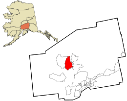 Location in Matanuska-Susitna Borough and the state of Alaska. | |
 Trapper Creek, Alaska Location within the state of Alaska | |
| Coordinates: 62°18′29″N 150°21′3″W / 62.30806°N 150.35083°WCoordinates: 62°18′29″N 150°21′3″W / 62.30806°N 150.35083°W | |
| Country | United States |
| State | Alaska |
| Borough | Matanuska-Susitna |
| Government | |
| • Borough mayor | |
| • State senator | Mike Dunleavy (R) |
| • State rep. | David Eastman (R) |
| Area | |
| • Total | 370.8 sq mi (960.3 km2) |
| • Land | 364.9 sq mi (945.1 km2) |
| • Water | 5.8 sq mi (15.1 km2) |
| Elevation | 351 ft (107 m) |
| Population (2010) | |
| • Total | 481 |
| • Density | 1.2/sq mi (0.4/km2) |
| Time zone | UTC-9 (Alaska (AKST)) |
| • Summer (DST) | UTC-8 (AKDT) |
| ZIP code | 99683 |
| Area code(s) | 907 |
| FIPS code | 02-78680 |
| GNIS feature ID | 1417100 |

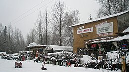
Trapper Creek is a census-designated place (CDP) in Matanuska-Susitna Borough, Alaska, United States. It is part of the Anchorage, Alaska Metropolitan Statistical Area and is known as the southern gateway to Denali State Park. According to the 2010 census the population was 481, up from 423 in 2000.
Geography[]
Trapper Creek is a community located in Matanuska-Susitna Borough at latitude 62.317 and longitude -150.231, with an elevation of 351 ft (107 m). It is on mile 114.5 on Parks Highway, just south of Denali State Park. Trapper Creek is found at the intersection of Petersville Road and is spread out along the Parks Highway 15 miles north of Talkeetna Junction. Also, Trapper Creek extends down the Petersville Road, which leads to mining, prospecting, and recreation country in the foothills of the Alaska Range.
According to the United States Census Bureau, the CDP has a total area of 370.8 square miles (960 km2), of which, 364.9 square miles (945 km2) of it is land and 5.8 square miles (15 km2) of it (1.58%) is water.
Demographics[]
| Historical population | |||
|---|---|---|---|
| Census | Pop. | %± | |
| 1990 | 296 | — | |
| 2000 | 423 | 42.9% | |
| 2010 | 481 | 13.7% | |
| U.S. Decennial Census[1] | |||
Trapper Creek first appeared on the 1990 U.S. Census as a census-designated place (CDP).
As of the census[2] of 2000, there were 423 people, 182 households, and 123 families residing in the CDP. The population density was 1.2 people per square mile (0.4/km2). There were 361 housing units at an average density of 1.0 per square mile (0.4/km2). The racial makeup of the CDP was 87.71% White, 0.24% Black or African American, 8.27% Native American, 0.47% Asian, and 3.31% from two or more races. 1.18% of the population were Hispanic or Latino of any race.
There were 182 households, out of which 24.7% had children under the age of 18 living with them, 52.2% were married couples living together, 8.2% had a female householder with no husband present, and 31.9% were non-families. 28.0% of all households were made up of individuals, and 5.5% had someone living alone who was 65 years of age or older. The average household size was 2.32 and the average family size was 2.74.
In the CDP, the population was spread out, with 22.7% under the age of 18, 5.2% from 18 to 24, 23.6% from 25 to 44, 39.0% from 45 to 64, and 9.5% who were 65 years of age or older. The median age was 44 years. For every 100 females, there were 121.5 males. For every 100 females age 18 and over, there were 125.5 males.
The median income for a household in the CDP was $27,031, and the median income for a family was $34,250. Males had a median income of $65,446 versus $11,250 for females. The per capita income for the CDP was $18,247. About 27.6% of families and 24.7% of the population were below the poverty line, including 16.7% of those under age 18 and 22.6% of those age 65 or over.
References[]
- ^ "U.S. Decennial Census". Census.gov. Retrieved June 6, 2013.
- ^ "U.S. Census website". United States Census Bureau. Retrieved 2008-01-31.
External links[]
| show Municipalities and communities of Matanuska-Susitna Borough, Alaska, United States |
|---|

| show Authority control |
|---|
- Census-designated places in Alaska
- Census-designated places in Matanuska-Susitna Borough, Alaska
- Anchorage metropolitan area