Trebinje
Trebinje
Требиње | |
|---|---|
| Grad Trebinje Град Требиње City of Trebinje | |
Clockwise, from top: Vew of Trebišnjica from Gornji Orahovac, Sultan Ahmed's mosque, Old town, Hercegovačka Gračanica, Panorama of Trebinje, Arslanagić Bridge | |
 Flag  Coat of arms | |
 Location of Trebinje within Republika Srpska | |
 | |
| Coordinates: 42°42′43″N 18°20′46″E / 42.712°N 18.346°ECoordinates: 42°42′43″N 18°20′46″E / 42.712°N 18.346°E | |
| Country | |
| Entity | |
| Geographical region | East Herzegovina |
| City status | July 2012 |
| Settlements | 178 |
| Government | |
| • Mayor | Mirko Ćurić (SNSD) |
| Area | |
| • City | 8,545 km2 (3,299 sq mi) |
| Elevation | 275 m (902 ft) |
| Population (2013 Census) | |
| • City | 31,433 |
| • Density | 36.8/km2 (95/sq mi) |
| • Urban | 25,589 |
| Time zone | UTC+1 (CET) |
| • Summer (DST) | UTC+2 (CEST) |
| Area code(s) | 59 |
| Website | www |


Trebinje (Serbian Cyrillic: Требиње, pronounced [trěːbiɲe]) is a town and municipality located in the Republika Srpska entity of Bosnia and Herzegovina. It is the southernmost city in Bosnia and Herzegovina and is situated on the banks of Trebišnjica river in the region of East Herzegovina. As of 2013, it has a population of 31,433 inhabitants. The city's old town quarter dates to the 18th-century Ottoman period, and includes the Arslanagić Bridge.
Geography[]
Physical geography[]
The city lies in the Trebišnjica river valley, at the foot of , in southeastern Herzegovina, some 30 km (19 mi) by road from Dubrovnik, Croatia, on the Adriatic coast. There are several mills along the river, as well as several bridges, including three in the city of Trebinje itself, as well as a historic Ottoman Arslanagić Bridge nearby. The river is heavily exploited for hydro-electric energy. After it passes through the Popovo Polje area southwest of the city, the river – which always floods in the winter – naturally runs underground to the Adriatic, near Dubrovnik. Trebinje is known as "the city of the sun and platan trees", and it is said to be one of the most beautiful cities in Bosnia and Herzegovina. The city is the economic and cultural center of the region of East Herzegovina.
Political geography[]
The Trebinje municipality is located in the most southern part of Republika Srpska and the municipalities of Bileća, Ljubinje and Ravno. The Trebinje municipality has an area of 904 km2 and makes up 3,68% of the total territory of the Republic of Srpska.
Climate[]
The climate is warm and temperate in Trebinje (Oceanic climate with Mediterranean precipitation patterns)(Cfc). The rain falls mostly in the winter, with relatively little rain in the summer. The average annual temperature is 14.2 °C in Trebinje. The average rainfall is 1338 mm. The warmest month of the year is July, with an average temperature of 23.3 °C and the coldest month of the year is January, with an average temperature of 5,4 °C.
| hideClimate data for Trebinje (1961–1990) | |||||||||||||
|---|---|---|---|---|---|---|---|---|---|---|---|---|---|
| Month | Jan | Feb | Mar | Apr | May | Jun | Jul | Aug | Sep | Oct | Nov | Dec | Year |
| Record high °C (°F) | 18.0 (64.4) |
20.0 (68.0) |
26.5 (79.7) |
27.0 (80.6) |
33.0 (91.4) |
37.0 (98.6) |
39.5 (103.1) |
39.0 (102.2) |
35.0 (95.0) |
31.5 (88.7) |
24.0 (75.2) |
20.5 (68.9) |
39.5 (103.1) |
| Daily mean °C (°F) | 5.4 (41.7) |
6.6 (43.9) |
9.0 (48.2) |
12.4 (54.3) |
16.8 (62.2) |
20.4 (68.7) |
23.3 (73.9) |
23.2 (73.8) |
19.5 (67.1) |
15.1 (59.2) |
10.4 (50.7) |
6.8 (44.2) |
14.1 (57.4) |
| Record low °C (°F) | −10.5 (13.1) |
−8.0 (17.6) |
−7.0 (19.4) |
−1.0 (30.2) |
2.5 (36.5) |
6.5 (43.7) |
8.0 (46.4) |
9.5 (49.1) |
5.0 (41.0) |
−2.0 (28.4) |
−10.5 (13.1) |
−10.5 (13.1) |
−10.5 (13.1) |
| Average precipitation mm (inches) | 179.1 (7.05) |
163.5 (6.44) |
154.2 (6.07) |
152.8 (6.02) |
86.2 (3.39) |
84.3 (3.32) |
52.2 (2.06) |
87.8 (3.46) |
125.1 (4.93) |
191.0 (7.52) |
232.8 (9.17) |
220.9 (8.70) |
1,730 (68.11) |
| Average precipitation days (≥ 1.0 mm) | 11 | 11 | 11 | 11 | 8 | 7 | 5 | 5 | 6 | 9 | 12 | 11 | 106 |
| Source: [1] | |||||||||||||
History[]
Middle Ages[]

De Administrando Imperio by Constantine VII (913–959) mentioned Travunija (Τερβουνια). Serbian Prince Vlastimir (r. 830–51) married his daughter to Krajina, the son of Beloje, and that family became hereditary rulers of Travunija. By 1040 Stefan Vojislav's state stretched in the coastal region from Ston in the north, down to his capital, Skadar, set up along the southern banks of the Skadar Lake, with other courts set up in Trebinje, Kotor and Bar.[2]
The town commanded the road from Ragusa to Constantinople, which was traversed in 1096 by Raymond IV of Toulouse and his crusaders.[3] Trebinje diocese has its episcopal seat in Polje near Trebinje.[4] At the end of the 12th century Stefan Nemanja conquered provinces that include Trebinje.[5] Under the name of Tribunia or Travunja it belonged to the Serbian Empire until 1355.[3] Trebinje became a part of the expanded medieval Bosnian state under Tvrtko I in 1373. There is a medieval tower in Gornje Police whose construction is often attributed to Vuk Branković. The old Tvrdoš Monastery dates back to the 15th century.
In 1482, together with the rest of Herzegovina (see: Herzog Stjepan Vukčić Kosača), the town was captured by the Ottoman Empire. The Old Town-Kastel was built by the Ottomans on the location of the medieval fortress of Ban Vir, on the western bank of the Trebišnjica River. The city walls, the Old Town square, and two mosques were built in the beginning of the 18th century by the Resulbegović family. The 16th-century Arslanagić bridge (or Perovica bridge[citation needed]) was originally built at the village of Arslanagić, 5 kilometres (3.1 mi) north of the town, by Mehmed-Paša Sokolović, and was run by Arslanagić family for centuries. The Arslanagić Bridge is one of the most attractive Ottoman-era bridges in Bosnia and Herzegovina. It has two large and two small semicircular arches.
Among noble families in the Trebinje region mentioned in Ragusan documents were Ljubibratić, , Popović, , , , , Kobiljačić, Paštrović, , and .[6]
Ottoman era[]
The burning of Saint Sava's remains after the Banat Uprising provoked the Serbs in other regions to revolt against the Ottomans.[7] Grdan, the vojvoda of Nikšić, organized revolt with Serbian Patriarch Jovan Kantul. From 1596, the center of anti-Ottoman activity in Herzegovina was the Tvrdoš Monastery in Trebinje, where Metropolitan Visarion was seated.[8] In 1596, the uprising broke out in Bjelopavlići, then spread to Drobnjaci, Nikšić, Piva and Gacko (see Serb Uprising of 1596–97). The rebels were defeated at the field of Gacko. It ultimately failed due to lack of foreign support.[8]
The hajduks in Herzegovina had in March 1655 carried out one of their greatest operations, raiding Trebinje, taking many slaves and carrying with them out much loot.[9]
On 26 November 1716, Austrian general Nastić with 400 soldiers and c. 500 hajduks attacked Trebinje, but did not take it over.[10] A combined Austro-Venetian-Hajduk force of 7,000 stood before the Trebinje walls, defended by 1,000 Ottomans.[10] The Ottomans were busy near Belgrade and with hajduk attacks towards Mostar, and were thus unable to reinforce Trebinje.[10] The conquest of Trebinje and Popovo field were given up to fight in Montenegro.[10] The Venetians took over and Popovo, where they immediately recruited militarily from the population.[10]
Turkish rule lasted from 1466. until 1878. The Trebinje region suffered especially in the 16th century, mostly from the hand of uskoks of Senj and various hajduk bands.[11] The calmer period during the Turkish rule was the 18th century.[11] The elders from Trebinje, together with the people of Nikšić, planned a great uprising in the summer of 1805, under the influence of the First Serbian Uprising. Their project was suppressed by the Turkish pasha and probably with the help from the Slavic Muslims.[11]
The Christians of Trebinje, together with the Montenegrins, fought against Napoleon's troops and in several conflicts they managed to defeat the French troops, such as the knife fight which took place on October 2–3, 1806 leaving several thousands of French soldiers dead, after which the French withdrew for a while.[11]
Notable participants in the Herzegovina Uprising (1852–62) from Trebinje include Mićo Ljubibratić.
During the Herzegovina Uprising (1875–77), the Bileća and Trebinje region was led by serdar Todor Mujičić, Gligor Milićević, Vasilj Svorcan and Sava Jakšić.

Austria-Hungary[]

With the Austro-Hungarian occupation of Bosnia and Herzegovina, many reforms took place. New administrative division was introduced and a large number of Austro-Hungarian troops were located in Trebinje, which was seen as a city of strategic value and position.[12] No factories or bigger investments were made in Trebinje during the AU rule.[12]
After the Assassination of Archduke Franz Ferdinand Croat-Muslim volunteer corps (German: Schutzcorp) terrorized Serb civilians of Bogojevići and other villages in Trebinje, which resulted in 83 children killed and 85 adults hanged.[13] Those and related actions resulted in migrations of the local population to Serbia.[14]
During the period of Austro-Hungarian administration (1878–1918), several fortifications were built on the surrounding hills, and there was a garrison based in the town. The imperial administrators also modernized the town, expanding it westwards, building the present main street, as well as several squares, parks, schools, tobacco plantations, etc.
SFR Yugoslavia (1945–92)[]
Trebinje grew rapidly in the era of Josip Broz Tito's Socialist Federal Republic of Yugoslavia between 1945 and 1980. It especially developed its hydroelectric potential with dams, artificial lakes, tunnels, and hydroelectric plants. This industrial development brought a large increase in the urban population of Trebinje.
Bosnian War (1992–95)[]
Trebinje was the largest town in Serb-held eastern Herzegovina during the Bosnian War. It was controlled by Bosnian Serb forces from the fall of 1991, and was used as a major command and artillery base by Yugoslav People's Army (JNA) troops besieging the Croatian town of Dubrovnik. In 1992 Trebinje was declared the capital of the self-proclaimed Serbian Autonomous Region of Herzegovina (Serbian: Српска аутономна област Херцеговина). Bosniak residents were subsequently conscripted to fight with the JNA and if refused they were executed, and thus they fled the region.[15] Ten of the town's mosques were razed to the ground during the war.[16]
Settlements[]
Trebinje is one of two municipalities created from the former Yugoslav municipality of Trebinje of the 1991 census, the other being Ravno in the Federation of Bosnia and Herzegovina. As of 2018, it has a total of 178 settlements that comprise it (including city proper area of Trebinje):
- Aranđelovo
- Arbanaška
- Arslanagića Most
- Baonine
- Begović Kula
- Bihovo
- Bijelač
- Bijograd
- Bioci
- Bodiroge
- Bogojević Selo
- Brani Do
- Brova
- Budoši
- Bugovina
- Cerovac
- Čvarići
- Desin Selo
- Diklići
- Dobromani
- Dodanovići
- Dolovi
- Domaševo
- Donja Kočela
- Donje Čičevo
- Donje Grančarevo
- Donje Vrbno
- Donji Orovac
- Dračevo
- Dražin Do
- Drijenjani
- Dubljani
- Dubočani
- Duži
- Glavinići
- Gojšina
- Gola Glavica
- Gomiljani
- Gornja Kočela
- Gornje Čičevo
- Gornje Grančarevo
- Gornje Vrbno
- Gornji Orovac
- Grab
- Grbeši
- Grbići
- Grkavci
- Grmljani
- Hum
- Janjač
- Jasen
- Jasenica Lug
- Jazina
- Jušići
- Klikovići
- Klobuk
- Konjsko
- Korlati
- Kotezi
- Kovačina
- Krajkovići
- Kremeni Do
- Krnjevići
- Kučići
- Kunja Glavica
- Lapja
- Lastva
- Lokvice
- Lomači
- Lug
- Lušnica
- Ljekova
- Ljubovo
- Marić Međine
- Mesari
- Mionići
- Morče
- Mosko
- Mrkonjići
- Mrnjići
- Necvijeće
- Nikontovići
- Ograde
- Orašje Popovo
- Orašje Površ
- Orašje Zubci
- Parojska Njiva
- Petrovići
- Pijavice
- Podosoje
- Podstrašivica
- Podštirovnik
- Podvori
- Poljice Čičevo
- Poljice Popovo
- Pridvorci
- Rapti Bobani
- Rapti Zupci
- Rasovac
- Sedlari
- Skočigrm
- Staro Slano
- Strujići
- Šćenica Ljubomir
- Taleža
- Todorići
- Trebijovi
- Tulje
- Turani
- Turmenti
- Tvrdoš
- Ugarci
- Ukšići
- Uvjeća
- Veličani
- Velja Gora
- Vladušići
- Vlaka
- Vlasače
- Vlaška
- Vrpolje Ljubomir
- Vrpolje Zagora
- Vučija
- Zgonjevo
- Žakovo
- Ždrijelovići
- Željevo
- Župa

Demographics[]
According to the 2013 census results, the city of Trebinje has 31,433 inhabitants.
Population[]
| Settlement | 1948 | 1953 | 1961 | 1971 | 1981 | 1991 | 2013 | |
|---|---|---|---|---|---|---|---|---|
| Total | 27,401 | 27,720 | 24,176 | 29,024 | 30,372 | 30,996 | 31,433 | |
| 1 | Bihovo | 658 | 305 | |||||
| 2 | Donje Čičevo | 258 | 497 | |||||
| 3 | Lastva | 523 | 368 | |||||
| 4 | Pridvorci | 419 | 632 | |||||
| 5 | Todorići | 121 | 260 | |||||
| 6 | Trebinje | 3,530 | 17,271 | 21,870 | 25,589 | |||
| 7 | Vrpolje Ljubomir | 73 | 278 |
Ethnic composition[]
| 2013 | 1991 | 1981 | 1971 | |
|---|---|---|---|---|
| Total | 25,589 (100,0%) | 21,870 (100,0%) | 17,271 (100,0%) | 3,530 (100,0%) |
| Serbs | 14,915 (68,20%) | 9,489 (54,94%) | 1,788 (50,65%) | |
| Bosniaks | 4,228 (19,33%) | 3,039 (17,60%) | 1,211 (34,31%) | |
| Yugoslavs | 1,470 (6,722%) | 3,364 (19,48%) | 124 (3,513%) | |
| Others | 910 (4,161%) | 158 (0,915%) | 51 (1,445%) | |
| Croats | 347 (1,587%) | 412 (2,386%) | 208 (5,892%) | |
| Montenegrins | 727 (4,209%) | 120 (3,399%) | ||
| Albanians | 31 (0,179%) | 7 (0,198%) | ||
| Macedonians | 29 (0,168%) | 2 (0,057%) | ||
| Slovenes | 22 (0,127%) | 19 (0,538%) |
| 2013 | 1991 | 1981 | 1971 | |
|---|---|---|---|---|
| Total | 31,433 (100,0%) | 30,966 (100,0%) | 30 372 (100,0%) | 29,024 (100,0%) |
| Serbs | 27,276 (93,42%) | 21,349 (68,94%) | 18,123 (59,67%) | 19,362 (66,71%) |
| Bosniaks | 995 (3,408%) | 5,571 (17,99%) | 4,405 (14,50%) | 4,846 (16,70%) |
| Others | 632 (2,165%) | 1 158 (3,740%) | 199 (0,655%) | 157 (0,541%) |
| Croats | 295 (1,010%) | 1 246 (4,024%) | 2,309 (7,602%) | 3,350 (11,54%) |
| Yugoslavs | 1 642 (5,303%) | 4,280 (14,09%) | 424 (1,461%) | |
| Montenegrins | 865 (2,848%) | 776 (2,674%) | ||
| Albanians | 119 (0,392%) | 59 (0,203%) | ||
| Macedonians | 36 (0,119%) | 18 (0,062%) | ||
| Slovenes | 22 (0,072%) | 32 (0,110%) | ||
| Roma | 14 (0,046%) |
Culture[]


The Serbian Orthodox church in Trebinje, Saborna Crkva, was built between 1888 and 1908. The Hercegovačka Gračanica monastery, a loose copy of the Gračanica monastery in Kosovo, was completed in 2000. The churches are located above the city, on the historic Crkvina Hill. The 15th-century Tvrdoš monastery is located two kilometres south-west of Trebinje, including a church which dates back to late antiquity. There is also the Roman Catholic Cathedral of the Birth of Mary in the town centre, as well as monuments dedicated to acclaimed poets Njegoš and Jovan Dučić (who was from the town). The Osman-Paša Resulbegović mosque, located in the Old Town, was originally built in 1726 and fully renovated in 2005. The Old Town walls are well preserved. The Arslanagić Bridge (1574) is located 1 km north of the town center.
Sports[]
The local football club, FK Leotar Trebinje, plays in the Premier League of Bosnia and Herzegovina.
Economy[]
The headquarters of Elektroprivreda Republike Srpske, which is the largest employer in Republika Srpska (as of 2016), is located in Trebinje. As of 2016, most of its economy is based on services.
The following table gives a preview of total number of registered people employed in legal entities per their core activity (as of 2018):[17]
| Activity | Total |
|---|---|
| Agriculture, forestry and fishing | 152 |
| Mining and quarrying | 9 |
| Manufacturing | 1,440 |
| Electricity, gas, steam and air conditioning supply | 1,286 |
| Water supply; sewerage, waste management and remediation activities | 214 |
| Construction | 362 |
| Wholesale and retail trade, repair of motor vehicles and motorcycles | 1,157 |
| Transportation and storage | 151 |
| Accommodation and food services | 521 |
| Information and communication | 134 |
| Financial and insurance activities | 128 |
| Real estate activities | 1 |
| Professional, scientific and technical activities | 174 |
| Administrative and support service activities | 136 |
| Public administration and defense; compulsory social security | 972 |
| Education | 635 |
| Human health and social work activities | 601 |
| Arts, entertainment and recreation | 124 |
| Other service activities | 157 |
| Total | 8,354 |
Transportation[]
Airport project[]
In late 2009 the Government of Republika Srpska approved funding for the Trebinje airport project. The airport was intended to serve as a low cost alternative to Dubrovnik.[18] The airport was intended to be operational in 2010 and then delayed till 2011. The terminal was planned to handle 260,000 passengers annually.[19] This is despite the airport not having been built. Over 820,000 euros have been spent on the project, mostly on documentation.[citation needed]
The plan for the Trebinje airport was resurrected in 2020 in the context of the RS-Serbia relations. The new airport will be built in the village of Mionići, some ten kilometres from Trebinje. It will feature a 3.5-kiloemtre runway, taxiways totalling 4.5 kilometres and a 7.000 square metre terminal building. The airport shall be in the full ownership of the Republic of Serbia, which will invest over EUR 50 million in its construction. Mladen Stanković, from the Niš Airport, was appointed head of the new airport management company. Works will be carried out by a consortium of Herzegovinian construction companies.[20] In September 2020, the RS passed a law on the special procedure of expropriation for the construction of the airport in Trebinje. First flights are expected by 2022, thought works at the airport will continue for up to 4 years.
Notable people[]


- Mićo Ljubibratić, voivode
- Asmir Begović, football goalkeeper
- Beba Selimović, sevdalinka singer
- Boris Savović, basketball player
- Branislav Krunić, footballer
- Dzeny, Bosnian-Swedish singer/songwriter
- Ivana Ninković, Olympic swimmer
- Nataša Ninković, Serbian actress
- Jovan Deretić, historian
- Jovan Dučić, poet and diplomat
- Luka Ćelović, businessman and philanthropist
- Nebojša Glogovac, Serbian actor
- Uroš Đerić, footballer
- Semjon Milošević, football player
- Igor Joksimović, footballer
- Siniša Mulina, footballer
- Srđan Aleksić, amateur actor
- Vladimir Gudelj, footballer
- Arnela Odžaković, karateka
- Vladimir Radmanović, Serbian NBA player, World champion
- Sabahudin Bilalović, basketball player
- Bogić Vučković, rebel leader
- Mijat Gaćinović, Serbian football player, World U-20 and European U-19 champion
- Marko Mihojević, footballer
- Tijana Bošković, Serbian volleyball player, World and European champion, silver medalist at the 2016 Summer Olympics
- Momčilo Mrkaić, footballer
Gallery[]

Serb national costume, 19th century

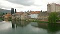
Trebišnjica river in Trebinje

View of Orovac, village belonging to the municipality of Trebinje
Old Town

View from the hill

Old stone houses in Central street

Jovan Dučić street

Hotel Platani
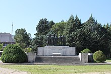
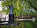
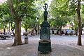
Monument to the Liberators and 120 years old platans
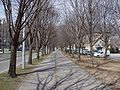
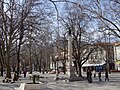
Pedestrian area

Church in Trebinje
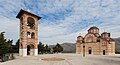
Nova Gračanica church
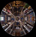
Spheric view of the interior of the Nova Gračanica church

Zavala monastery (founded in the 13th century) and the surrounding landscape

Osman-pasha's mosque
Monument dedicated to Petar II Petrović Njegoš

Bust of king Peter I of Serbia

Monument dedicated to Pavle, Serbian Patriarch
A fountain in the city


References[]
- ^ "Klimatski podaci za Trebinje (niz 1961 – 1990)" (in Bosnian). Meteorological Institute of Bosnia and Herzegovina. Retrieved 21 June 2018.
- ^ Fine 1991, p. 206.
- ^ Jump up to: a b One or more of the preceding sentences incorporates text from a publication now in the public domain: Chisholm, Hugh, ed. (1911). "Trebinje". Encyclopædia Britannica. 27 (11th ed.). Cambridge University Press. p. 232.
- ^ Muhamed Hadžijahić; (1985) Pitanje rasprostranjenosti Metodove nadbiskupije južno od Save (in Croatian) p.4; Croatica Christiana periodica, Vol. 9 No. 15, [1]
- ^ Ivica Puljić, 2015, Sedam stoljeća otoka Mrkana u naslovu trebinjskih biskupa, https://hrcak.srce.hr/153752, #page= 91
- ^ Milan Vasić (1995). Bosna i Hercegovina od srednjeg veka do novijeg vremena: međunarodni naučni skup 13-15. decembar 1994. Istorijski institut SANU. p. 77. ISBN 9788677430078.
- ^ Bataković 1996, p. 33.
- ^ Jump up to: a b Ćorović, Vladimir (2001) [1997]. "Преокрет у држању Срба". Историја српског народа (in Serbian). Belgrade: Јанус.
- ^ Mihić 1975, p. 181.
- ^ Jump up to: a b c d e Mihić 1975, p. 196.
- ^ Jump up to: a b c d Храбак, Богумил (2005). "Требињски крај у време првог српског устанка". Трабуниа. 11.
- ^ Jump up to: a b Mirjanović, Zoran (2005). "Služba civilne zaštite u srezu Trebinjskom između dva svjetska rata". Trabunia. 11: 139–140.
- ^ Vidić, Velibor (2015). Suffering and compassion Valjevo hospital 1914-1915. Archive of Serbia. p. 11.
- ^ Vidić, Velibor (2015). Suffering and compassion Valjevo hospital 1914-1915. Archive of Serbia. p. 11.
- ^ Human Rights Watch 1993, p. 382.
- ^ Bose 2002, p. 156.
- ^ "Cities and Municipalities of Republika Srpska" (PDF). rzs.rs.ba. Republika Srspka Institute of Statistics. 25 December 2019. Retrieved 31 December 2019.
- ^ "Trebinje to get airport in 2010". Limun.hr. Retrieved 23 November 2013.
- ^ "EX-YU Aviation News: "Trebinje Airport doubles passenger numbers"". Exyuaviation.blogspot.com. 1 February 2013. Retrieved 23 November 2013.
- ^ Sarajevo Times
Sources[]
- Bose, Sumantra (2002). Bosnia After Dayton: Nationalist Partition and International Intervention. Oxford: Oxford University Press. ISBN 978-0-19-515848-9.
- Human Rights Watch (1993). War Crimes in Bosnia-Hercegovina, Volume 2. New York: Human Rights Watch. ISBN 978-1-56432-097-1.
- Bataković, Dušan T. (1996). The Serbs of Bosnia & Herzegovina: History and Politics. Dialogue Association. ISBN 9782911527104.
External links[]
| Wikimedia Commons has media related to Trebinje. |
| hide | ||||
|---|---|---|---|---|
|  | |||
| ||||
| ||||
| ||||
| show Authority control |
|---|
- Trebinje
- Cities and towns in Republika Srpska
- Popovo Polje