Tren Francés
 A coach of the Tren Francés in Las Tunas station depot | |||||
| Overview | |||||
|---|---|---|---|---|---|
| Service type | Inter-city rail | ||||
| Status | Ceased operating | ||||
| Locale | |||||
| Current operator(s) | Ferrocarriles de Cuba | ||||
| Route | |||||
| Start | Havana | ||||
| Stops | 4 | ||||
| End | Santiago de Cuba | ||||
| Distance travelled | 854 km (531 mi) | ||||
| Average journey time | 14 hours, 45 minutes[1] | ||||
| Service frequency | Every 3 days[1] | ||||
| Train number(s) | 1 and 2[1][2] | ||||
| Line(s) used | |||||
| On-board services | |||||
| Class(es) | 1st and 2nd[3] | ||||
| Sleeping arrangements | no | ||||
| Auto-rack arrangements | no | ||||
| Catering facilities | On-board cafeteria | ||||
| Technical | |||||
| Rolling stock | 1 diesel locomotive (from CR) 12 ex-TEE coaches (from SNCF) | ||||
| Track gauge | 1,435 mm (4 ft 8+1⁄2 in) | ||||
| |||||

Tren Francés (Spanish for "French Train") was the name of the flagship Cuban InterCity service between Havana and Santiago.[4] Owned by Ferrocarriles de Cuba, it was operated by SNCF ex-Trans Europ Express (TEE) , originally used in Europe between Paris and Amsterdam, on the Étoile du Nord service and used in France between Paris and Nice on Le Mistral. Both of these two French flagship trains were replaced by TGV and Thalys from 1982 (Mistral) to 1996 (Étoile du Nord). The Tren Francés was formed by 12 coaches and a Chinese-built diesel locomotive.[5]
Over the years, the coaches deteriorated. In 2019, the service was replaced by a new service using Chinese-built coaches.
Overview[]
The Tren Francés (also spelled El Francés or Especial),[2][6] named after the country of origin of the coaches (France), donated by SNCF to FFCC in 2001,[3][7] was the fastest long-distance service in Cuba. It had the most modern coaches and was divided into two classes named primera especial (1st) and primera (nominally 1st, identifiable as 2nd). There were no sleeping cars, couchettes or car-carrying wagons.[3]
Route[]
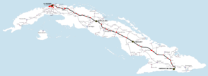
Travelling along the , the Tren Francés made intermediate stops only at the main cities of Santa Clara and Camagüey. Other important cities traversed along the route were Matanzas, Colón, Ciego de Ávila, Florida, and Las Tunas. Some junction stations to nearby provincial capitals were served at Cabaiguán (for Sancti Spíritus) and Cacocum (for Holguín).
- Havana – Santiago (eastbound)[1]
|
- Santiago – Havana (westbound)[1]
| Station | Time | Km / Mi | City served |
|---|---|---|---|
| Santiago de Cuba | 20:17 | 0 km (0 mi) | Santiago de Cuba |
| Camagüey | 02:07 | 316 km (196 mi) | Camagüey |
| Santa Clara | 06:38 | 568 km (353 mi) | Santa Clara |
| Havana Central | 10:57 | 854 km (531 mi) | Havana |
See also[]
References[]
- ^ a b c d e Cuban long-distance timetables at seat61.com (section "Train times & fares")
- ^ a b (in Spanish) "The railway in Cuba" on hicuba.com
- ^ a b c seat61.com - no longer mentions Tren Francés
- ^ (in Spanish) Ferrocarriles de Cuba (network) on EcuRed
- ^ The Tren Francés on cubacasas.net
- ^ (in Spanish) Some info about the Tren Francés on santiagoencuba.com Archived 2014-03-06 at the Wayback Machine
- ^ (in Spanish) Ferrocarriles de Cuba (actuality) on EcuRed
External links[]
| Wikimedia Commons has media related to Tren Francés. |
- Named passenger trains of Cuba
- Night trains
- 2001 establishments in Cuba
