Turda
This article needs additional citations for verification. (February 2007) |
Turda | |
|---|---|
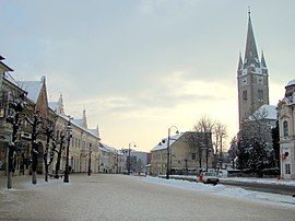 Republic Square | |
 Coat of arms | |
 Location in Cluj County | |
 Turda Location in Romania | |
| Coordinates: 46°34′N 23°47′E / 46.567°N 23.783°ECoordinates: 46°34′N 23°47′E / 46.567°N 23.783°E | |
| Country | Romania |
| County | Cluj |
| Government | |
| • Mayor (2020–2024) | Cristian-Octavian Matei[1] (PNL) |
| Area | 91.43 km2 (35.30 sq mi) |
| Elevation | 315 m (1,033 ft) |
| Highest elevation | 436 m (1,430 ft) |
| Lowest elevation | 310 m (1,020 ft) |
| Population (2011)[2] | 47,744 |
| • Density | 520/km2 (1,400/sq mi) |
| Time zone | EET/EEST (UTC+2/+3) |
| Postal code | 401001–401189 |
| Area code | +40 x64 |
| Vehicle reg. | CJ |
| Website | primariaturda |

Turda (Romanian pronunciation: [ˈturda]; German: Thorenburg; Hungarian: Torda; Latin: Potaissa) is a city in Cluj County, Transylvania, Romania. It is located in the southeastern part of the county, 34.2 km (21.3 mi) from the county seat, Cluj-Napoca, to which it is connected by the European route E81, and 6.7 km (4.2 mi) from nearby Câmpia Turzii.
The city consists of three neighborhoods: Turda Veche, Turda Nouă, and Oprișani. It is traversed from west to east by the Arieș River and north to south by its tributary, Valea Racilor.
History[]
Ancient times[]
There is evidence of human settlement in the area dating to the Middle Paleolithic, some 60,000 years ago.[3] The Dacians established a town that Ptolemy in his Geography calls Patreuissa, which is probably a corruption of Patavissa or Potaissa, the latter being more common. It was conquered by the Romans, who kept the name Potaissa, between AD 101 and 106, during the rule of Trajan, together with parts of Decebal's Dacia.[4]
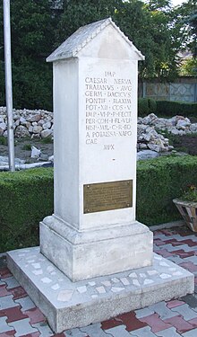
The name Potaissa is first recorded on a Roman milliarium discovered in 1758 in the nearby Aiton commune.[5]

Milliarium of Aiton is an ancient Roman milestone dating from 108 AD, shortly after the Roman conquest of Dacia, and showing the construction of the road from Potaissa to Napoca, by demand of the Emperor Trajan. It indicates the distance of 10,000 feet (3,000 m) (P.M.X.) to Potaissa. This is the first epigraphical attestation of the settlements of Potaissa and Napoca in Roman Dacia.
The complete inscription is: "Imp(erator)/ Caesar Nerva/ Traianus Aug(ustus)/ Germ(anicus) Dacicus/ pontif(ex) maxim(us)/ (sic) pot(estate) XII co(n)s(ul) V/ imp(erator) VI p(ater) p(atriae) fecit/ per coh(ortem) I Fl(aviam) Vlp(iam)/ Hisp(anam) mil(liariam) c(ivium) R(omanorum) eq(uitatam)/ a Potaissa Napo/cam / m(ilia) p(assuum) X". It was recorded in the Corpus Inscriptionum Latinarum, vol.III, the 1627, Berlin, 1863.
This milliarium is an attestation of the road known to be built by Cohors I Hispanorum miliaria.[6]
The castrum established was named Potaissa too and became a municipium, then a colonia. Potaissa was the basecamp of the Legio V Macedonica from 166 to 274.
The Potaissa salt mines were worked in the area since prehistoric times.
Middle Ages[]
After the Hungarian conquest, the Turda salt mines were first mentioned in 1075. They were closed in 1932 but have recently been reopened for tourism.
Saxons settled in the area in the 12th century. The town was destroyed during the Tartar invasion in 1241–1242. Andrew III of Hungary gave royal privileges to the settlement. These privileges were later confirmed by the Angevins of Hungary.[citation needed]
The Hungarian Diet was held here in 1467, by Matthias Corvinus. Later, in the 16th century, Turda was often the residence of the Transylvanian Diet, too. After the Battle of Mohács, the city became part of the Eastern Hungarian Kingdom and since 1570 the Principality of Transylvania. The 1558 Diet of Turda declared free practice of both the Catholic and Lutheran religions. In 1563 the Diet also accepted the Calvinist religion, and in 1568 it extended freedom to all religions, declaring that "It is not allowed to anybody to intimidate anybody with captivity or expelling for his religion" – a freedom unusual in medieval Europe. This Edict of Turda is the first attempt at legislating general religious freedom in Christian Europe (though its legal effectiveness was limited).
In 1609 Gabriel Báthori granted new privileges to Turda. These were confirmed later by Gabriel Bethlen. In the battle of Turda, Ahmed Pasha defeated George II Rákóczi in 1659.
Modern times[]
In 1711 the Grand Principality of Translyvania was formed which became in 1804 part of the Austrian Empire. In 1867, by the Austro-Hungarian Compromise, the city became again part of Hungary. After the First World War following the proclamation of the Union of Transylvania with Romania, Turda as well became part of Romania by the Treaty of Trianon.[7] In 1944, the Battle of Turda took place here, between German and Hungarian forces on one side and Soviet and Romanian forces on the other. It was the largest battle fought in Transylvania during World War II.
From the late 1950s, Turda became a rather important industrial centre, housing factories for chemical, electrotechnical ceramics, cement, glass and steel cables. The nearby Câmpia Turzii town hosted a siderurgy (steel) plant. The city centre of Turda saw redevelopment in the late 1980s, including a House of Culture that hasn't been finished up to this date. Many houses in the historic center were demolished to create space for apartment buildings. The town's role of an industrial powerhouse has diminished from the 1990s onwards, but tourist attractions have kept the city in a good state up to today.[citation needed]
Climate[]
Turda has a continental climate, characterised by warm dry summers and cold winters. The climate is influenced by the city's proximity to the Apuseni Mountains, as well as by urbanisation. Some West-Atlantic influences are present during winter and autumn. Winter temperatures are often below 0 °C (32 °F), even though they rarely drop below −10 °C (14 °F). On average, snow covers the ground for 65 days each winter. In summer, the average temperature is approximately 18 °C (64 °F) (the average for July and August), despite the fact that temperatures sometimes reach 35 °C (95 °F) to 40 °C (104 °F) in mid-summer in the city centre. Although average precipitation and humidity during summer is low, there are infrequent yet heavy and often violent storms. During spring and autumn, temperatures vary between 13 °C (55 °F) to 18 °C (64 °F), and precipitation during this time tends to be higher than in summer, with more frequent yet milder periods of rain.[citation needed]
Demographics[]
| Year | Pop. | ±% |
|---|---|---|
| 1912 | 13,455 | — |
| 1930 | 20,023 | +48.8% |
| 1948 | 25,905 | +29.4% |
| 1956 | 33,614 | +29.8% |
| 1966 | 42,307 | +25.9% |
| 1977 | 55,294 | +30.7% |
| 1992 | 61,200 | +10.7% |
| 2002 | 55,770 | −8.9% |
| 2011 | 47,744 | −14.4% |
| Source: Census data | ||
According to the Hungarian census from year 1910, from 13,455 inhabitants 9,674 were Hungarians, 3,389 Romanians and 100 Germans.[8]
According to the last Romanian census from 2011 there were 47,744 people living within the city.
Of this population, 84.7% are ethnic Romanians, while 8.98% are ethnic Hungarians, 6.03% ethnic Roma and 0.4% others.[9]
Notable people[]
- Eta Boeriu
- Miklós Bogáthi Fazekas
- Andreea Cacovean
- Horia Crișan
- Radu Crișan
- Emilian Dolha
- Veronica Drăgan
- Moise Dragoș
- Étienne Hajdú
- Miklós Jósika
- Baruch Kimmerling
- Ecaterina Orb-Lazăr
- Andrei Mureșan
- Ionuț Mureșan
- Camil Mureșanu
- Mona Muscă
- Cristina Pîrv
- Ion Rațiu
- Alin Rus
- Júlia Sigmond
- Ion Suru
- Rareș Takács
- István Timár-Geng
- Moise Vass
- Cosmin Vâtcă
Tourism[]
- Salina Turda
- Cheile Turzii
See also[]
- Decree of Turda
- Universitas Valachorum
- List of Transylvanian Saxon localities
- Ancient history of Transylvania, History of Transylvania
- Franziska Tesaurus
- Edict of Torda
International relations[]
Twin towns – sister cities[]
Turda is twinned with:
 Angoulême[10]
 Hódmezővásárhely
 Santa Susanna
 Torda
Torda
Picture gallery[]

City Hall

Mendel Villa
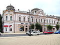
Palace of Finance
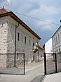
Princely Palace, now the History Museum

Orthodox Cathedral


References[]
- ^ "Results of the 2020 local elections". Central Electoral Bureau. Retrieved 11 June 2021.
- ^ "Populaţia stabilă pe judeţe, municipii, oraşe şi localităti componenete la RPL_2011" (in Romanian). National Institute of Statistics. Retrieved February 4, 2014.
- ^ (in Romanian) "Comuna primitivă" at the Turda City Hall site; accessed March 21, 2013
- ^ (in Romanian) "Epoca dacică" at the Turda City Hall site; accessed March 21, 2013
- ^ Lazarovici et al. 1997, pp. 202–3 (6.2 Cluj in the Old and Ancient Epochs)
- ^ "ARCHAEOLOGICAL REPERTORY OF ROMANIA. Archive Of The Vasile Parvan Institute Of Archaeology – Site Location Index". Retrieved September 20, 2014.
- ^ (in Romanian) "Turda în perioada interbelică" at the Turda City Hall site; accessed June 3, 2013
- ^ "1910. ÉVI NÉPSZÁMLÁLÁS 1. A népesség főbb adatai községek és népesebb puszták, telepek szerint (1912) | Könyvtár | Hungaricana".
- ^ "Structura Etno-demografică a României". Edrc.ro. Retrieved October 8, 2017.
- ^ "National Commission for Decentralised cooperation". Délégation pour l’Action Extérieure des Collectivités Territoriales (Ministère des Affaires étrangères) (in French). Archived from the original on August 5, 2013. Retrieved December 26, 2013.
Bibliography[]
- "INP - Museums and Collections in Romania". Cimec.ro. Retrieved October 8, 2017.
- "Turda - Romania". Britannica.com. Retrieved October 8, 2017.
External links[]
| Wikimedia Commons has media related to Turda. |
- (in Romanian) Official site of the city hall
- TurdaTurism.ro
- Fundatia Potaissa
| show Cluj County, Romania |
|---|

| show Ancient Dacian cities and/or fortresses |
|---|

| show Authority control |
|---|
- Turda
- Archaeological sites in Romania
- Populated places in Cluj County
- Localities in Transylvania
- Cities in Romania
- Roman sites in Romania
- Roman towns and cities in Romania
- Dacian towns
- Mining communities in Romania
- Capitals of former Romanian counties
- Roman legionary fortresses in Romania