Turkestan–Siberia Railway
This article includes a list of references, related reading or external links, but its sources remain unclear because it lacks inline citations. (February 2013) |
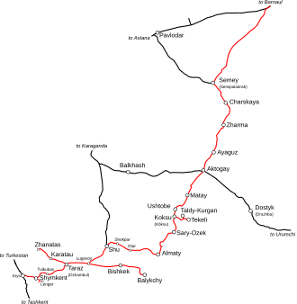 The Turkestan-Siberia route. | |
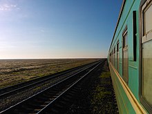
Video of Turksib railway in southern Kazakhstan steppe | |
| Overview | |
|---|---|
| Locale | Kazakhstan |
| Dates of operation | 1929–current |
| Technical | |
| Track gauge | 1,520 mm (4 ft 11+27⁄32 in) broad gauge |

| hide Turkestan–Siberia railway | ||||||||||||||||||||||||||||||||||||||||||||||||||||||||||||||||||||||||||||||||||||||||||||||||||||||||||||||||||||||||||||||||||||||||||||||||||||||||||||||||||||||||||||||||||||||||||||||||||||||||||||||||||||||||||||||||||||||||||||||||||||
|---|---|---|---|---|---|---|---|---|---|---|---|---|---|---|---|---|---|---|---|---|---|---|---|---|---|---|---|---|---|---|---|---|---|---|---|---|---|---|---|---|---|---|---|---|---|---|---|---|---|---|---|---|---|---|---|---|---|---|---|---|---|---|---|---|---|---|---|---|---|---|---|---|---|---|---|---|---|---|---|---|---|---|---|---|---|---|---|---|---|---|---|---|---|---|---|---|---|---|---|---|---|---|---|---|---|---|---|---|---|---|---|---|---|---|---|---|---|---|---|---|---|---|---|---|---|---|---|---|---|---|---|---|---|---|---|---|---|---|---|---|---|---|---|---|---|---|---|---|---|---|---|---|---|---|---|---|---|---|---|---|---|---|---|---|---|---|---|---|---|---|---|---|---|---|---|---|---|---|---|---|---|---|---|---|---|---|---|---|---|---|---|---|---|---|---|---|---|---|---|---|---|---|---|---|---|---|---|---|---|---|---|---|---|---|---|---|---|---|---|---|---|---|---|---|---|---|---|---|---|---|---|---|---|---|---|---|---|---|---|---|---|---|---|---|
| ||||||||||||||||||||||||||||||||||||||||||||||||||||||||||||||||||||||||||||||||||||||||||||||||||||||||||||||||||||||||||||||||||||||||||||||||||||||||||||||||||||||||||||||||||||||||||||||||||||||||||||||||||||||||||||||||||||||||||||||||||||
The Turkestan–Siberian Railway (commonly abbreviated as the Turk–Sib, Kazakh: Түрксіб, romanized: Türksib, Arabic: تٷركسٸب, pronounced [tʏɾkˈsɪb]; Russian: Турксиб, romanized: Turksib) is a 1,520 mm (4 ft 11+27⁄32 in) broad gauge railway that connects Central Asia with Siberia. It starts north of Tashkent in Uzbekistan at Arys, where it branches off from the Trans-Aral Railway. It heads roughly northeast through Shymkent, Taraz, Bishkek (on a spur) to the former Kazakh capital of Almaty. There it turns northward to Semey before crossing the Russian border. It passes through Barnaul before ending at Novosibirsk, where it meets the West Siberian portion of the Trans-Siberian railway. The bulk of construction works was undertaken between 1926 and 1931.
Construction history[]
The idea of a railway between Siberia and Russian Turkestan was aired as early as 1886, but it was supplanted by that of a more practicable line between Tashkent and Orenburg in the Urals. On 15 October 1896 the Verny town duma set up a commission to examine the feasibility of building a Turkestan–Siberia Railway. It was expected that the line would facilitate transport of cotton from Turkestan to Siberia and cheap Siberian grain from Russia to the Fergana Valley. An eastern branch would enhance Russia's military and economic presence on the Chinese border.
In 1906 the Russian imperial government decided to finance construction of the first section, between Barnaul and Arys. A team of Russian engineers made a detailed survey of the steppe and semi-desert regions the railway was expected to cross. On 21 October 1915 the northern section linking Novosibirsk and Semipalatinsk as the . The missing Arys–Pishpek–Tokmak section, officially known as Semipalatinsk Railway, was left to be built by a French-financed Russian-managed private railway consortium. World War I put an end of this project.
After the Bolshevik Revolution construction work was suspended for a decade, and the 140-kilometre (87 mi) long Semipalatinsk–Ayaguz line, built in 1918–19 by the White Russians on the initiative of Admiral Kolchak, was demolished for no apparent reason. The remaining 1,442 kilometres (896 mi) of railway were constructed with great fanfare as part of the first five-year plan between 1928 and 1932.
Regular passenger service was finally established between Semipalatinsk and Ayaguz on 10 May 1929. The Turksib was completed on 21 April 1930. The locomotive which pioneered the route going from Tashkent to Semipalatinsk (Э-1441(rus)) later became a part of a memorial in Alma-Ata.
directed a 1929 Soviet documentary film on the building of the railway which also bore the name Turksib.
Connectivity[]
Years after the Turksib was completed, it was joined at Shu by Kazakhstan's main north-south line, which serves Karaganda, Nur-Sultan and Petropavlovsk, on one of the main Transsib routes.
In 1990, Aktogay station, roughly midway between Alma-Ata and Semipalatinsk, became an important junction. Lines from there run east, connecting at Dostyk with China's Lanxin railway Line (toward Urumqi, Lanzhou, and heartland China); and west, to Balkhash and Karaganda.
References[]
- Vitali A. Rakov. Russian Locomotives, 2nd ed. Moscow, 1995.
- Inkerin suomalaiset GPU:n kourissa. Helsinki 1942. Inkerin karkoitettujen kirjeitä. Helsinki 1943.
- Eugene Lyons, Locomotives Come to Central Asia, a chapter in Assignment in Utopia
External links[]
Coordinates: 44°37′24″N 77°59′32″E / 44.62333°N 77.99222°E

| Authority control |
|
|---|
- Rail transport in the Soviet Union
- Railway lines in Russia
- Rail transport in Siberia
- Railway lines in Kazakhstan
- Rail transport in Kyrgyzstan
- Rail transport in Uzbekistan
- Railway lines opened in 1931
- International railway lines