Ubbergen
Ubbergen | |
|---|---|
Village and former municipality | |
 Church in Beek | |
 Flag  Coat of arms | |
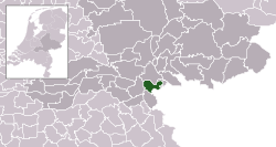 Location in Gelderland | |
| Coordinates: 51°50′N 5°55′E / 51.833°N 5.917°ECoordinates: 51°50′N 5°55′E / 51.833°N 5.917°E | |
| Country | Netherlands |
| Province | Gelderland |
| Municipality | Berg en Dal |
| Area | |
| • Total | 38.88 km2 (15.01 sq mi) |
| • Land | 33.77 km2 (13.04 sq mi) |
| • Water | 5.11 km2 (1.97 sq mi) |
| Elevation | 13 m (43 ft) |
| Population (January 2019)[3] | |
| • Total | data missing |
| Demonym(s) | Ubberger |
| Time zone | UTC+1 (CET) |
| • Summer (DST) | UTC+2 (CEST) |
| Postcode | 6570–6579 |
| Area code | 024 |
| Website | www |

Ubbergen (Dutch pronunciation: [ʏˈbɛrɣə(n)] (![]() listen)) is village and former municipality in the eastern Netherlands, in the province of Gelderland. The village is part of the municipality of Berg en Dal (formerly known as Groesbeek).
listen)) is village and former municipality in the eastern Netherlands, in the province of Gelderland. The village is part of the municipality of Berg en Dal (formerly known as Groesbeek).
Notable people[]
Notable people who were born in Ubbergen include:
- Don Burgers (1932–2006), Dutch politician for the KVP and the CDA
- Amber (1970), Dutch-German singer, songwriter and music producer
- Yelmer Buurman (1987), Dutch professional racing driver
Gallery[]
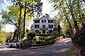
Villa 'De Maartenshof' on the Rijkstraatweg
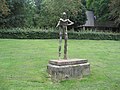
Statue of Nescio (1991) on the Rijksstraatweg

The school building of Notre Dame des Anges

'De Refter': monumental building complex

The 'Bronnenbos': a carr in Ubbergen


References[]
- ^ "Kerncijfers wijken en buurten 2020" [Key figures for neighbourhoods 2020]. StatLine (in Dutch). CBS. 24 July 2020. Retrieved 19 September 2020.
- ^ "Postcodetool for 6573CL". Actueel Hoogtebestand Nederland (in Dutch). Het Waterschapshuis. Retrieved 18 July 2014.
- ^ "Bevolkingsontwikkeling; regio per maand" [Population growth; regions per month]. CBS Statline (in Dutch). CBS. 1 January 2019. Retrieved 1 January 2019.
External links[]
 Media related to Ubbergen at Wikimedia Commons
- Official website
| Authority control |
|
|---|
This Gelderland location article is a stub. You can help Wikipedia by . |
Categories:
- Former municipalities of Gelderland
- Populated places in Gelderland
- Geography of Berg en Dal (municipality)
- Gelderland geography stubs