Ucayali River
This article needs additional citations for verification. (February 2015) |
| Ucayali River | |
|---|---|
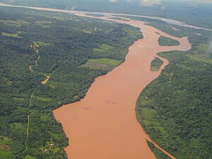 Confluence of the Tambo (from bottom) and Urubamba Rivers (background right) forming the Ucayali River (background left) | |
 Map of the Amazon Basin with the Ucayali River highlighted | |
| Location | |
| Country | Peru |
| Physical characteristics | |
| Source | confluence of the Tambo and Urubamba Rivers |
| • location | Atalaya, Ucayali, Peru |
| Mouth | Amazon River |
• location | confluence with Marañón River, Loreto, Peru |
| Length | 1,460 km (910 mi)[1] |
| Discharge | |
| • average | 13,500 m3/s (480,000 cu ft/s) |
The Ucayali River (Spanish: Río Ucayali, IPA: [ˈri.o ukaˈʝali]) is the main headstream of the Amazon River. It rises about 110 km (68 mi) north of Lake Titicaca, in the Arequipa region of Peru and becomes the Amazon at the confluence of the Marañón close to Nauta city. The city of Pucallpa is located on the banks of the Ucayali.
Description[]
The Ucayali, together with the Apurímac River, the Ene River and the Tambo River, is today considered the main headwater of the Amazon River, totaling a length of 2,669.9 kilometres (1,659.0 mi) from the source of the Apurímac at Nevado Mismi to the confluence of the Ucayali and Marañón Rivers:
- Apurímac River (total length): 730.7 km (454.0 mi)
- Ene River (total length): 180.6 km (112.2 mi)
- Tambo River (total length): 158.5 km (98.5 mi)
- Ucayali River (confluence with Tambo River to confluence with the Marañón): 1,600.1 km (994.3 mi)
Exploration[]
The Ucayali was first called San Miguel, then Ucayali, Ucayare, Poro, Apu-Poro, Cocama and Rio de Cuzco. Peru has organised many costly and ably-conducted expeditions to explore it. One of them (1867) claimed to have reached within 380 km (240 mi) of Lima, and the little steamer "Napo" found its way up the violent currents for 124 km (77 mi) above the junction with the Pachitea River, and as far as the Tambo River, 1,240 km (770 mi) from the confluence of the Ucayali with the Amazon. The "Napo" then succeeded in ascending the Urubamba River 56 km (35 mi) upstream from its junction with the Tambo, to a point 320 km (200 mi) north of Cuzco.
[]
Its width varies from 400–1,200 metres (1,300–3,900 ft), due to the large number of islands. The current runs from 5–6 kilometres per hour (3.1–3.7 mph), and a channel from 20–50 metres (66–164 ft) wide can always be found with a minimum depth of 1.5 m (4.9 ft). There are five difficult passes, due to the accumulation of trees and rafts of timber. Sometimes large rocks which have fallen from the mountains and spread over the river-bed cause whirlpools.
National Reserve[]
Ucayali is home to the Amazon river dolphin, giant otter, and the Amazonian manatee, which are abundant in Pacaya-Samiria National Reserve, close to Nauta. The southeastern border of the reserve is formed by the lower Ucayali River.
The river gives its name to the Ucayali Region of Peru and the Ucayali Province of the Loreto Region.
References[]
- ^ Ziesler, R.; Ardizzone, G.D. (1979). "Amazon River System". The Inland waters of Latin America. Food and Agriculture Organization of the United Nations. ISBN 92-5-000780-9. Archived from the original on 8 November 2014.
External links[]
| Wikimedia Commons has media related to Ucayali River. |
Coordinates: 8°35′31″S 74°21′59″W / 8.59188°S 74.36646°W

| Authority control |
|---|
- Rivers of Peru
- Tributaries of the Amazon River
- Rivers of Loreto Region
- Rivers of Ucayali Region
- Upper Amazon