Tambo River (Peru)
This article does not cite any sources. (December 2009) |
| Tambo River | |
|---|---|
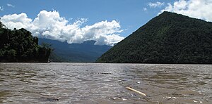 View of the Tambo River near Puerto Prado | |
 Map of large rivers in south-central Peru | |
| Location | |
| Country | Peru |
| Physical characteristics | |
| Source | Confluence of Ene and Perené Rivers |
| • location | Peru |
| • coordinates | 11°9′56″S 74°14′7″W / 11.16556°S 74.23528°W |
| • elevation | 400 m (1,300 ft) |
| Mouth | Ucayali River |
• location | confluence with Urubamba River, Peru |
• coordinates | 10°41′57″S 73°45′22″W / 10.69917°S 73.75611°WCoordinates: 10°41′57″S 73°45′22″W / 10.69917°S 73.75611°W |
• elevation | 287 m (942 ft) |
| Length | 159 km (99 mi) |
| Discharge | |
| • average | 2,800 m3/s (99,000 cu ft/s) |

The Tambo River (Spanish: Río Tambo) is a Peruvian river on the eastern slopes of the Andes. The name only refers to a relatively short section; about 159 km (99 mi) long. It starts at the confluence of the Ene and Perené Rivers at the town of . From here the Tambo River flows 70 km (43 mi) in an easterly direction and then turns north. When merging with the Urubamba River at the town of Atalaya, it becomes the Ucayali River.
The Tambo is part of the headwaters of the Amazon River whose origin is the Mantaro River at [[Cordilerra Ruminator Cruz ]].
| Authority control |
|
|---|
This Ucayali Region geography article is a stub. You can help Wikipedia by . |
Categories:
- Tributaries of the Amazon River
- Rivers of Peru
- Tributaries of the Ucayali River
- Rivers of Junín Region
- Rivers of Ucayali Region
- Peru geography stubs
- Peru river stubs