Ugar (river)
| Ugar Угар | |
|---|---|
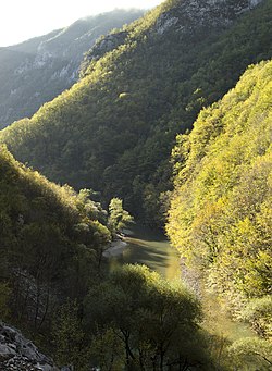 Ugar river, at the bottom of its deep canyon | |
 Ugar river in Bosnia and Herzegovina | |
| Location | |
| Country | Bosnia and Herzegovina |
| Canton | Srednja Bosna |
| Physical characteristics | |
| Source | |
| • location | Prelivode, Vlašić Mt. |
| • coordinates | 44°20′38″N 17°39′22″E / 44.34397°N 17.6561°E |
| • elevation | ~1,590 m (5,220 ft) |
| Mouth | |
• location | Vrbas |
• coordinates | 44°27′12″N 17°14′20″E / 44.45345°N 17.23890°ECoordinates: 44°27′12″N 17°14′20″E / 44.45345°N 17.23890°E |
• elevation | 268 m (879 ft) |
| Length | 44.5 km (27.7 mi) |
| Basin size | 328 km2 (127 sq mi) |
| Discharge | |
| • location | Mouth |
| • average | 6.98 m3/s (246 cu ft/s) |
| Basin features | |
| Progression | Vrbas→ Sava→ Danube→ Black Sea |
| Tributaries | |
| • right | Ugrić, Pljačkovac, Ilomska, Kobilja, Zirin potok, Kusin potok |
| Waterfalls | several |

The Ugar (Serbian Cyrillic: Угар) also known as the Brzica until 1878)[1] is a river of Bosnia, a tributary of the Vrbas river. It appears at the slopes of Vlašić, upstream of Sažići and Melina villages (at around of 1590 meters above sea level), a watershed area of Vrbanja, Ilomska and Bila rivers.

Geography and hydrology[]
The Ugar's length is around 44.5 kilometres, and its catchment is around 328 km2. Its largest right tributaries are: Pljačkovac, Ilomska, Kobilja, Zirin Potok and Kusin Potok (Ziro's and Kuso's creeks), and Ugrić; left tributaries are the creeks: namely Lužnica Potok, Dedića Potok, Andrijevića Potok, Bunar, Oraški Potok, and Kukavički Potok.[2][3][4]
At its source Ugar and its headwaters tributaries creates series of waterfalls. After short, but deep canyon (below the Babanovac plateau) it enters into Pougarje, under the Ranča Mountain. By this, Ugar flows into a deep and long canyon under Skender Vakuf, around 20 kilometres downstream of Jajce. Notch of the Canyon is a very arduous and its maximal depth is (approximately) 500 m. The area in the valley along the Ugar, from Vitovlje to its Canyon is marked as Pougarje[5]
See also[]
References[]
- ^ Džaja M. (1995): Pougarje i njegova okolica. Monografija.
- ^ "Karta BiH - Karta Bosne i Hercegovine". kartabih.com. Retrieved 2014-08-06.
- ^ Spahić M. et al. (2000): Bosna i Hercegovina (1:250.000). Izdavačko preduzeće „Sejtarija“, Sarajevo.
- ^ Mučibabić B., Ed. (1998): Geografski atlas Bosne i Hercegovine. Geodetski zavod BiH, Sarajevo.
- ^ Vojnogeografski institut, Ed.. (1955): Travnik (List karte 1:100.000, Izohipse na 20 m). Vojnogeografski institut, Beograd.

- Tributaries of the Vrbas
- Rivers of Bosnia and Herzegovina
- Ugar