Buna (Neretva)
This article does not cite any sources. (August 2013) |
| Buna Буна | |
|---|---|
 The Buna river | |
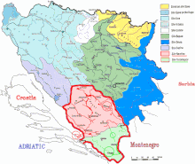 Neretva basin | |
 Location of the Buna mouth in Bosnia and Herzegovina | |
| Location | |
| Country | Bosnia and Herzegovina |
| Physical characteristics | |
| Source | |
| • location | Vrelo Bune near Blagaj |
| Mouth | |
• location | The Neretva near Buna |
• coordinates | 43°14′26″N 17°50′02″E / 43.2405°N 17.8340°ECoordinates: 43°14′26″N 17°50′02″E / 43.2405°N 17.8340°E |
| Length | 9 km (5.6 mi) |
| Basin features | |
| Progression | Neretva→ Adriatic Sea |

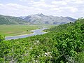
The Buna (Serbian Cyrillic: Буна) is a short river in Bosnia and Herzegovina; it is a left bank tributary of the Neretva. Its source (Vrelo Bune), a strong karstic spring, is near the village Blagaj, southeast of Mostar. It is best known for the Buna Spring (Vrelo Bune), one of the strongest springs in Europe and extremely cold water. The Buna flows west for approximately 9 km, starts at Blagaj and meandering through villages Blagaj, Kosor, Malo Polje, Hodbina and joins the Neretva at settlement Buna. The Bunica river is main left bank tributary of the Buna.
See also[]
- Vrelo Bunice
- Mostarska Bijela
- Hutovo Blato
- Daorson
- List of Illyrian cities

| show Hydrography of Bosnia and Herzegovina |
|---|
| Authority control |
|
|---|
Categories:
- Tributaries of the Neretva
- Rivers of Bosnia and Herzegovina
- Springs of Bosnia and Herzegovina
- Fly fishing in Bosnia and Herzegovina
- Blagaj
- Upper Horizons Hydroelectric Power Stations System
- Bosnia and Herzegovina river stubs