Ulvetanna Peak
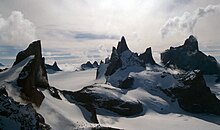
Ulvetanna Peak (Norwegian: the wolf's tooth, German: Matterhorn[1]) is a sharp peak (2,930 m) in Queen Maud Land, Antarctica. It was first climbed in February 1994. The mountain was first discovered by the German Antarctic expedition in 1938 and named after the Swiss mountain Matterhorn because of its similar form. Later the mountain was also named by the Norwegians to Ulvetanna.
Location[]
Ulvetanna lies about 2 miles (3.2 km) north of Kinntanna Peak in the Fenriskjeften Mountain (Norwegian: Fenrir's maw) in the east part of Queen Maud Land, Antarctica. The peak is one of the most demanding on the continent and its mile-long north east ridge has been described as one of “the last great climbs”.[2] Mapped from surveys and air photos by the Sixth Norwegian Antarctic Expedition (1956–60) and named Ulvetanna.
First ascent[]
The summit was first reached in February 1994 by , and by the NW face.[3]
Later ascents[]
- In November 2006 Caspersen and Tollefsen returned and with and climbed the North face in 16 days.[3]
- In December 2008 by Alexander Huber, Thomas Huber and by the NW buttress.
- In December 2010 Valery Rozov made a wingsuit BASE jump from the peak, flying 45 seconds in the air before opening his parachute.
- Between December 2012 and January 2013, a team led by Leo Houlding and including , Chris Rabone, Sean 'Stanley' Leary, Jason Pickles and David Reeves made the first ascent of a new route up the north-east ridge. This expedition is well documented in Lee's film, The Last Great Climb (2013, Posing Productions)[2]
- Between January and February 2014, a team led by Andy Kirkpatrick and including Aleksander Gamme, Jonas Langseth, Kjersti Eide, Ingeborg Jacobsen, and Espen Fadnes made an ascent of the South Ridge in 12 days.
Footnotes[]
- ^ Scientific Committee on Antarctic Research (SCAR). "Matterhorn". COMPOSITE GAZETTEER OF ANTARCTICA.
- ^ Jump up to: a b "British expedition achieves first ascent of new Antarctic route". Berghaus. 28 January 2013. Retrieved 14 December 2013.
- ^ Jump up to: a b Dougald MacDonald. "New Route on Antarctica's Stunning Ulvetanna". Retrieved 14 December 2013.
![]() This article incorporates public domain material from the United States Geological Survey document: "Ulvetanna Peak". (content from the Geographic Names Information System)
This article incorporates public domain material from the United States Geological Survey document: "Ulvetanna Peak". (content from the Geographic Names Information System) ![]()
| Wikimedia Commons has media related to Ulvetanna. |
Coordinates: 71°51′S 8°20′E / 71.850°S 8.333°E

| Authority control |
|---|
- Mountains of Queen Maud Land
- Princess Astrid Coast
- Princess Astrid Coast geography stubs