Unguja North Region
Unguja North Region
Mkoa wa Unguja Kaskazini (Swahili) | |
|---|---|
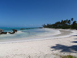 Matemwe beach | |
 Location in Tanzania | |
| Country | Tanzania |
| Zone | Zanzibar |
| Capital | Mkokotoni |
| Area | |
| • Total | 470 km2 (180 sq mi) |
| Population (2012) | |
| • Total | 187,455 |
| • Density | 400/km2 (1,000/sq mi) |
| Time zone | UTC+3 (EAT) |
| Postcode | 73xxx |
| Area code(s) | 024 |
| HDI (2018) | 0.560[1] medium · 6th of 25 |
| Website | www |
Unguja North Region is one of the 31 regions of Tanzania. Located on the island of Zanzibar, Mkokotoni serves as the region's capital. Zanzibar North is divided into two districts, Kaskazini A and Kaskazini B.[2]
Districts[]

Map
The region is administratively divided into two districts:
| Districts of Unguja North Region | ||
|---|---|---|
| District | Population (2012) | |
| Kaskazini A | 105,780 | |
| Kaskazini B | 81,675 | |
| Total | 187,455 | |
Kaskazini A[]
As of 2002, Kaskazini A had a population of 84,348.[3] As of 2007, it was divided into twenty-eight wards:[4]
|
|
|
Kaskazini B[]
As of 2002, Kaskazini B had a population of 84,348.[3] As of 2007, it was divided into twenty-three wards:[5]
|
|
|
Constituencies[]
As of 2010 election Zanzibar North Region had eight constituencies:[6][7]
| Kaskazini A Constituencies |
|
Kaskazini B Constituencies |
|---|---|---|
| Chaani Constituency | Bumbwini Constituency | |
| Matemwe Constituency | Donge Constituency | |
| Mkwajuni Constituency | Kitope Constituency | |
| Nungwi Constituency | ||
| Tumbatu Constituency |
References[]
Unguja North Regionat Wikipedia's sister projects
 Media from Wikimedia Commons
- ^ "Sub-national HDI - Area Database - Global Data Lab". hdi.globaldatalab.org. Retrieved 2020-02-26.
- ^ "Zanzibar North Region - Tanzania". Africa Development Information. 2007.
- ^ Jump up to: a b "2002 Tanzania National Census – North Unguja (North Zanzibar)". Archived from the original on 18 March 2004.
- ^ "Kaskazini A District - Tanzania". Africa Development Information. 2007.
- ^ "Kaskazini B District - Tanzania". Africa Development Information. 2007.
- ^ "Organisations located in Zanzibar North Region - Tanzania". African Development Information.
- ^ "2010 Parliamentary Election Results - As received by NEC". National Electoral Commission of Tanzania (NEC).
Coordinates: 5°55′00″S 39°20′00″E / 5.9167°S 39.3333°E

This Zanzibar North Region location article is a stub. You can help Wikipedia by . |
Categories:
- Unguja North Region
- Regions of Tanzania
- Geography of Zanzibar
- Zanzibar geography stubs