Upper Angara
| Upper Angara | |
|---|---|
 View from the BAM railway bridge across the Upper Angara near Novy Uoyan | |
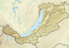 Mouth location in Buryatia, Russia | |
| Location | |
| Country | Russia |
| Physical characteristics | |
| Source | Delyun-Uran Range Stanovoy Highlands |
| • coordinates | 56°36′51″N 113°45′21″E / 56.61417°N 113.75583°E |
| • elevation | 1,600 m (5,200 ft) |
| Mouth | Lake Baikal |
• coordinates | 55°42′24″N 109°52′33″E / 55.70667°N 109.87583°ECoordinates: 55°42′24″N 109°52′33″E / 55.70667°N 109.87583°E |
| Length | 438 km (272 mi) |
| Basin size | 21,400 km2 (8,300 sq mi) |
| Discharge | |
| • average | 258 m3/s (9,100 cu ft/s) |
| Basin features | |
| Progression | Lake Baikal→ Angara→ Yenisey→ Kara Sea |

The Upper Angara (Russian: Верхняя Ангара, Verkhnyaya Angara; Buryat: Дээдэ Ангар, Deede Angar) is a river in Buryatia, Siberia to the northeast of Lake Baikal. the third longest river in the Baikal basin. It is 438 kilometres (272 mi) long, and has a drainage basin of 21,400 square kilometres (8,300 sq mi).[1]
The Baikal–Amur Mainline runs along the north side of the river northeast up its valley, crossing between Anamakit and Novy Uoyan and crossing the river a second time upstream before heading into the mountains.[2]
Course[]
The Upper Angara rises at about 1,600 m (5,200 ft) in an area of small glacial lakes of the Delyun-Uran range, right by the Northern Muya Range, Stanovoy Highlands. It its upper course the river flows in a WSW direction across mountainous terrain, with rapids and waterfalls. It enters then a floodplain and crosses the spurs of the Upper Angara and the Barguzin ranges. Near Yanchukan it flows through the Upper Angara tectonic basin. Finally it ends in Lake Baikal forming a delta in the shallow northern end of the lake, separated from the deep part by long sandy spits, including . The Upper Angara is navigable in its last stretch.[3]
The main tributaries of the Upper Angara are the 64 km (40 mi) long Angarakan, the 87 km (54 mi) long , the 124 km (77 mi) long Churo and the 245 km (152 mi) long .[1]
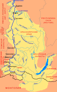 Yenisei basin with the Upper Angara at the NE end of Lake Baikal. |
 Upper Angara Range and Upper Angara River. |
See also[]
References[]
- ^ a b Река Верхняя Ангара in the State Water Register of Russia (Russian)
- ^ [1] Wikimapia approximate site of basin
- ^ Верхняя Ангара - Water of Russia
External links[]
- , Encyclopædia Britannica, 9th ed., Vol. II, New York: Charles Scribner's Sons, 1878, p. 26.
This Buryatia location article is a stub. You can help Wikipedia by . |
This article related to a river in Russia is a stub. You can help Wikipedia by . |
- Tributaries of Lake Baikal
- Rivers of Buryatia
- Stanovoy Highlands
- Buryatia geography stubs
- Buryatia stubs
- Russia river stubs