Upper Denkyira West District
Upper Denkyira West District | |
|---|---|
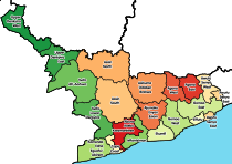
 Districts of Central Region | |
 Upper Denkyira West District Location of Upper Denkyira West District within Central | |
| Coordinates: 6°9′12.24″N 2°9′26.28″W / 6.1534000°N 2.1573000°W | |
| Country | |
| Region | |
| Capital | Diaso |
| Government | |
| • District Chief Executive | Richmond Kodua |
| • Member of Parliament | Daniel Ohene Darko |
| Area | |
| • Total | 579.21 km2 (223.63 sq mi) |
| Population (2021) | |
| • Total | 91,025 [1] |
| Time zone | UTC+0 (GMT) |
| ISO 3166 code | GH-CP-UW |
| Website | http://udwda.gov.gh/?page_id=508 |

Upper Denkyira West District is one of the twenty-two districts in Central Region, Ghana.[2][3][4][5][6] Originally it was formerly part of the then-larger Upper Denkyira District in 1988, which was created from the former Denkyira District Council, until the northwest part of the district was split off to create Upper Denkyira West District on 29 February 2008; thus the remaining part has been renamed as Upper Denkyira East District (which it was later elevated to municipal district assembly status on that same year to become Upper Denkyira East Municipal District). The district assembly is located in the northwest part of Central Region and has Diaso as its capital town.
List of settlements[]
| Settlements of Upper Denkyira West District (20 largest communities in the District and their population) [1] | |||
| No. | Settlement | Population | Population year |
|---|---|---|---|
| 1 | Ayanfuri | 4,660 | 2010 |
| 2 | Diaso | 4,492 | 2010 |
| 3 | Dominase | 2,993 | 2010 |
| 4 | Nkotumso | 2,955 | 2010 |
| 5 | 2,891 | 2010 | |
| 6 | Maudaso | 2203 | 2010 |
| 7 | Bethlehem | 1,999 | 2010 |
| 8 | New Obuasi | 1,546 | 2010 |
| 9 | Nkronua Anaafo | 1,531 | 2010 |
| 10 | Akwaboso | 1,455 | 2010 |
| 11 | Afiefiso | 1,397 | 2010 |
| 12 | Besease | 1,353 | 2010 |
| 13 | Jameso Nkwanta | 1,340 | 2010 |
| 14 | Nyinawusu-Awiaso | 1,334 | 2010 |
| 15 | Ameyaw | 1,214 | 2010 |
| 16 | Ayanfuri-Gyaman | 1,166 | 2010 |
| 17 | Kwameprakrom | 1,153 | 2010 |
| 18 | Abora | 1,078 | 2010 |
| 19 | Treposo | 1,069 | 2010 |
| 20 | Bremang | 995 | 2010 |
Sources[]
References[]
- ^ |https://www2.statsghana.gov.gh/docfiles/2010_District_Report/Central/Upper%20Denkyira%20West.pdf
- ^ "District: Upper Denkyira West". Archived from the original on 2012-03-23. Retrieved 2012-05-17.
- ^ "Obuasi: One feared dead after Anglogold Ashanti mining pit caved in". Citinewsroom - Comprehensive News in Ghana. 2021-05-19. Retrieved 2021-05-19.
- ^ "'Galamsey' fight: Denkyira Adaboe residents unhappy with alleged military invasion - MyJoyOnline.com". www.myjoyonline.com. Retrieved 2021-05-19.
- ^ "Desist from leaking information to public - Central Regional Minister tells public servants". Graphic Online. Retrieved 2021-05-20.
- ^ "Central Region: Death toll in Breman mining pit collapse still three – Police". Citinewsroom - Comprehensive News in Ghana. 2021-05-28. Retrieved 2021-05-29.
| Metropolitan (1) |
|  |
|---|---|---|
| Municipal (7) |
| |
| Ordinary (14) |
| |
Coordinates: 6°9′12.24″N 2°9′26.28″W / 6.1534000°N 2.1573000°W
Categories:
- Central Region (Ghana)
- Districts of the Central Region (Ghana)
- Central Region, Ghana geography stubs