Ust-Chorna
Ust-Chorna
Усть-Чорна | |
|---|---|
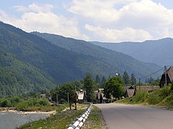 View of the mountains surrounding Ust-Chorna. | |
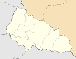 Ust-Chorna Location of Ust-Chorna in Zakarpattia Oblast | |
| Coordinates: 48°19′09″N 23°56′20″E / 48.31917°N 23.93889°ECoordinates: 48°19′09″N 23°56′20″E / 48.31917°N 23.93889°E | |
| Country | |
| Oblast | |
| Raion | |
| Established | 1760s |
| Town status | 1957 |
| Elevation | 536 m (1,759 ft) |
| Population (2021) | |
| • Total | |
| Time zone | UTC+2 (EET) |
| • Summer (DST) | UTC+3 (EEST) |
| Postal code | 90520 |
| Area code | +380 3134 |
| Website | http://rada.gov.ua/ |


Ust-Chorna (Ukrainian: Усть-Чорна; German: Königsfeld; Hungarian: Királymező; Slovak: Usť-Čorna or historically Kraľovo Pole) is an urban-type settlement in Tiachiv Raion (district) of Zakarpattia Oblast (region) in western Ukraine.[2] The town's population was 1,456 as of the 2001 Ukrainian Census.[2] Current population: 1,564 (2021 est.)[3].
References[]
| Wikimedia Commons has media related to Ust-Chorna. |
- ^ "Ust-Chorna (Zakarpattia Oblast, Tiachiv Raion)". weather.in.ua. Retrieved 25 December 2012.
- ^ Jump up to: a b "Ust-Chorna, Zakarpattia Oblast, Tiachiv Raion". Regions of Ukraine and their Structure (in Ukrainian). Verkhovna Rada of Ukraine. Retrieved 25 December 2012.
- ^ "Чисельність наявного населення України (Actual population of Ukraine)" (PDF) (in Ukrainian). State Statistics Service of Ukraine. Retrieved 11 July 2021.
| show Authority control |
|---|
This article about a location in Zakarpattia Oblast is a stub. You can help Wikipedia by . |
Categories:
- Urban-type settlements in Zakarpattia Oblast
- Populated places established in the 1760s
- Zakarpattia Oblast geography stubs