Solotvyno
Solotvyno
Slatina | |
|---|---|
Urban-type settlement | |
 Coat of arms | |
 Solotvyno | |
| Coordinates: 47°57′20″N 23°52′16″E / 47.95556°N 23.87111°ECoordinates: 47°57′20″N 23°52′16″E / 47.95556°N 23.87111°E | |
| Country | |
| Oblast | |
| Raion | Tiachiv Raion |

Solotvyno (Ukrainian: Солотвино, Hungarian: Aknaszlatina, Romanian: Slatina, Rusyn: Солотвино, Yiddish: סעלאָטפֿינע, Slovak: Slatinské Doly) is an urban-type settlement in Tiachiv Raion in Zakarpattia Oblast of Ukraine, located close to the border with Romania, on the right bank of the Tisza River (across from the Romanian city of Sighetu Marmaţiei). The village's name comes from the nearby salt mine (sol’ (соль) in Russian means salt).
Solotvyno was first mentioned ca. 1360 (the former one was burned down by the Tatars in 1241). Population: 8,484 (2021 est.)[1].
Solotvino is the final stop of the Ukrainian section of the railway, which runs from Lviv to Transcarpathia.
The village has an original museum of salt miners.
Notable residents[]
- Robert Maxwell, British MP, business owner and fraudster (1923–1991).[2][3]
Gallery[]
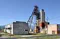
A salt mine in the town of Solotvyno
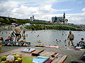
Recreation camp, "El dorado"


Underground office of the hospital

Former synagogue

Former synagogue, now bakery

Old Jewish cemetery

New Jewish cemetery
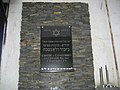
Jewish memorial plaque


See also[]
References[]
- ^ "Чисельність наявного населення України (Actual population of Ukraine)" (PDF) (in Ukrainian). State Statistics Service of Ukraine. Retrieved 11 July 2021.
- ^ Марк Штейнберг. Евреи в войнах тысячелетий. p. 227. ISBN 5-93273-154-0 (in Russian)
- ^ Иван Мащенко (September 7–13, 2002). Медиа-олигарх из Солотвина. Зеркало недели (in Russian) (#34 (409)). Archived from the original on 2012-12-22.
External links[]
| Authority control: National libraries |
|---|
This article about a location in Zakarpattia Oblast is a stub. You can help Wikipedia by . |
- Urban-type settlements in Zakarpattia Oblast
- Mining cities and regions in Ukraine
- Zakarpattia Oblast geography stubs