Uts (river)
This article does not cite any sources. (December 2019) |
| Uts Vuts | |
|---|---|
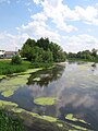
 Uts River in a middle flow | |
| Native name |
|
| Location | |
| Country | Belarus |
| Physical characteristics | |
| Source | |
| • location | Dobrush District |
| Mouth | |
• location | Sozh |
• coordinates | 52°14′39″N 30°56′33″E / 52.2443°N 30.9426°ECoordinates: 52°14′39″N 30°56′33″E / 52.2443°N 30.9426°E |
| Length | 75 km (47 mi) |
| Basin size | 433 km2 (167 sq mi) |
| Basin features | |
| Progression | Sozh→ Dnieper→ Dnieper–Bug estuary→ Black Sea |

The Uts or Vuts (Belorussian:Уць or Вуць, Russian:Уть), is a 75-kilometre-long (47 mi) river in the Gomel Region of Belarus.
The Uts flows on the territory of Dobrush District and Gomel District and is a left tributary of the Sozh.
Uts River in its upstream between Vysoky Hutor and Uts Village, Dobrush Raion, Homyel Voblast

The bridge across Uts River connecting Uts Village and Vysoky Hutor, Dobrush Raion, Homyel Voblast


External links[]
![]() Media related to Vuts River, Belarus at Wikimedia Commons
Media related to Vuts River, Belarus at Wikimedia Commons
Categories:
- Tributaries of the Dnieper
- Rivers of Gomel Region
- Rivers of Belarus
- Europe river stubs
- Belarus geography stubs