Uyuni Municipality
This article uses bare URLs, which may be threatened by link rot. (September 2021) |
Uyuni Municipality | |
|---|---|
Municipality | |
 Uyuni | |
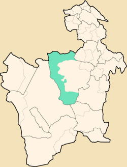 Location within Potosí Department | |
 Uyuni Municipality Location within Bolivia | |
| Coordinates: 20°3′S 66°56′W / 20.050°S 66.933°WCoordinates: 20°3′S 66°56′W / 20.050°S 66.933°W | |
| Country | |
| Department | Potosí Department |
| Province | Antonio Quijarro Province |
| Seat | Uyuni |
| Elevation | 11,980 ft (3,650 m) |
| Population (2001) | |
| • Total | 18,705 |
| • Ethnicities | Quechua Aymara |
| Time zone | UTC-4 (BOT) |

Uyuni Municipality is the first municipal section of the Antonio Quijarro Province in the Potosí Department in Bolivia. Its seat is Uyuni.
Geography[]
The municipality lies at the Uyuni salt flat.
Some of the highest mountains of the municipality are listed below:[1]
- Jach'a Punta
- Jalsuri
- Janq'u Qullu
- Kuntur Ikiña
- Pirwani
- Sura Chata
- Warachi Qullu
- Wila Qullu
Subdivision[]
The municipality consists of the following cantons:
- Chacala
- Coroma
- Huanchaca
- Pulacayo
- Uyuni
The people[]
The people are predominantly indigenous citizens of Quechua and Aymara descent.[2]
| Ethnic group | % |
|---|---|
| Quechua | 52.9 |
| Aymara | 24.2 |
| Guaraní, Chiquitos, Moxos | 0.2 |
| Not indigenous | 22.6 |
| Other indigenous groups | 0.2 |
References[]
External links[]

| show Authority control |
|---|
Categories:
- Municipalities of Potosí Department
- Potosí Department geography stubs