Vahitahi Airport
Vahitahi Airport Aérodrome de Vahitahi | |||||||||||
|---|---|---|---|---|---|---|---|---|---|---|---|
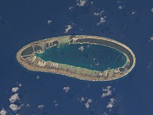 NASA satellite image of Vahitahi | |||||||||||
| Summary | |||||||||||
| Airport type | Public | ||||||||||
| Operator | DSEAC Polynésie Française | ||||||||||
| Serves | Vahitahi, Tuamotu, French Polynesia | ||||||||||
| Elevation AMSL | 3 m / 10 ft | ||||||||||
| Coordinates | 18°46′48″S 138°51′11″W / 18.78000°S 138.85306°WCoordinates: 18°46′48″S 138°51′11″W / 18.78000°S 138.85306°W | ||||||||||
| Map | |||||||||||
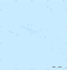 VHZ Location of the airport in French Polynesia | |||||||||||
| Runways | |||||||||||
| |||||||||||
Vahitahi Airport (IATA: VHZ, ICAO: NTUV) is an airport that serves the village of Mohitu, located on the Vahitahi atoll, in the Tuamotu group of atolls in French Polynesia, 960 kilometres (600 mi) from Tahiti. Vahitahi atoll Airport was inaugurated in 1978.
References[]
- ^ NTUV – Vahitahi. AIP from French Service d'information aéronautique, effective 27 January 2022.
- ^ Airport information for NTUV at Great Circle Mapper.
- ^ Airport information for Vahitahi Airport at Transport Search website.
External links[]
Tuamotus Gambiers | Islands/Atolls | ||
|---|---|---|---|
| Island groups | |||
This article about an Oceanian airport is a stub. You can help Wikipedia by . |
This French Polynesia-related geography article is a stub. You can help Wikipedia by . |
Categories:
- Airports in French Polynesia
- Atolls of the Tuamotus
- Oceanian airport stubs
- French Polynesia geography stubs