Vale do Anhangabaú
Vale do Anhangabaú (Anhangabaú Valley) is a region in the of São Paulo, located between the viaducts do Chá and .[1] It is a public space commonly characterized as park, where events have traditionally been organized, such as public demonstrations, political rallies, presentations and popular shows. It is considered the point that separates the Old City Center from the New City Center.[2]

Currently, the 43 thousand square meters of the Anhangabaú Valley are used as a crossing point for people wishing to transit between the east and west regions of the Center, and can be defined as an extensive boardwalk under a road junction. The space also interconnects with other squares in the central area, such as , juxtaposed with the Valley, , through the steps of the Metro and , which currently houses a bus station.[3]
With gardens, works of art and three fountains, Vale do Anhangabaú is today a postcard of the City Center of São Paulo, from where it is possible to glimpse buildings, also characterized as postcards, such as the Martinelli, Altino Arantes, Teatro Municipal, and Matarazzo Building, headquarters of . The space also acts as a stage for Virada Cultural, a traditional event in São Paulo that promotes shows and cultural activities throughout the city.[4] Due to its wide dimension, the Valley is considered an adequate space for large public meetings and was even the stage for the largest Brazilian public rally, in the Diretas Já demonstrations, organized on April 16, 1984, when it was received about 1.5 million people.[4] In addition to being in a region that houses all the places mentioned above, the Vale do Anhangabaú is also located near the Dramatic and Musical Conservatory of São Paulo, which is called the School of Dance of São Paulo, also known as . Basically, it is a university campus that concentrates classes on public dance in the city.[5]
History[]
Origins and first occupations[]

The Anhangabaú River, which gave origin to the Valley, is born as Saracura Stream, which runs through and goes through the Anhangabaú Valley, reaching its mouth at Tamanduateí River, at the47 edge of Municipal Market. Thus, the Tamanduateí constitutes a kind of delta with its main tributary, Anhangabaú. The name Anhangabaú possibly derives from the fact that its waters are very ferreous and acidic - in Tupi, it means "poisonous water".[2] The indigenous people considered the river cursed and, currently, it is channeled and hidden, except for its springs, which are outdoors, between the regions of Vila Mariana and Paraíso.[2] Because of its size, the Valley was the scene of historical facts of great national importance, such as the inauguration of the Viaduto do Chá in 1892, the channeling of Anhangabaú River in 1906, and the replacement of the park's gardens by avenues, in 1940, following the architectural changes of the city.[2]
Landscaping and reurbanisation[]
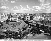

In 1910, a great afforestation of the Anhangabaú Valley was carried out, resulting in the formation of the Anhangabaú Park. This project took shape from a combination of three projects, including "Grandes Avenidas", by the architect , which resulted in the urbanization of the valley with the insertion of buildings.
Expressway and remodeling[]

In the late 1930s, the park was disbanded and gave way to an expressway. In the following decade, an underground connection was created between the Ramos de Azevedo and the squares: the , where the city's first escalators were installed. The intersection between Avenida Anhangabaú and gained a different height in 1951, with the construction of , which remained there for 37 years, being subsequently replaced by two homonymous tunnels (Papa João Paulo II). The east side of the valley was gradually remodeled in the middle of the 20th century, with the demolition of the three , between 1935 and 1970, giving way to taller buildings.[6]
In the early 1980s, the Municipality held a public tender for the remodeling of the region. The urban planners and Rosa Grena Kliass were the winners, proposing a revitalization project that created a slab over the existing avenues on the site, at a height sufficient to connect the two sides of the Valley, with the car traffic falling below and recreating the green area between Viaduto do Chá and . The main focus was to transform the Valley into a large boulevard, to resume the original function of its construction at the beginning of the 20th century.
Political manifestations[]
This section is empty. You can help by . (December 2020) |
References[]
- ^ Vale do Anhangabaú | Pontos Turísticos | Portal do Governo do Estado de São Paulo, accessed 13 september 2016.
- ^ Jump up to: a b c d "Vale do Anhangabaú - Monumentos". Monumentos. 2013-07-18.
- ^ "O Vale do Anhangabaú". Gestão Urbana SP. Retrieved 2018-11-23.
- ^ Jump up to: a b Vale do Anhangabaú - São Paulo City Tourism Official Site, accessed 13 september 2016.
- ^ "Vale do Anhangabaú". Governo do Estado de São Paulo. Retrieved 2018-11-19.
- ^ Amaral, Luiz (March 1, 2013). "Os palacetes do Anhangabaú". Preserva SP. Retrieved March 3, 2020.
Bibliography[]
- TOLEDO, Benedito Lima de; São Paulo - três cidades em um século, São Paulo: Cosac e Naify, 2004
- MACEDO, Silvio Soares; Praças brasileiras, São Paulo: Edusp, 2001
External links[]
 Media related to Vale do Anhangabaú at Wikimedia Commons
| show Authority control |
|---|
- São Paulo