Vallée des merveilles

The Vallée des Merveilles, also known in Italian as the Valle delle Meraviglie (English: Valley of Marvels), is a part of the Mercantour National Park in southern France. It holds the largest quantity of open-air Bronze Age petroglyphs in Europe, after Val Camonica in Italy, and is given special note for the area's inclusion for the European Diploma of Protected Areas.[1]
Location[]
The valley is located near the Italian border, in the rugged mountains of the Argentera massif within the Maritime Alps, between Saint-Martin-Vésubie and Tende.
Petroglyphs[]
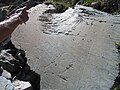
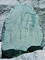
The petroglyphs (rock engravings), located on stone outcrops within the valley, were first identified by British amateur archaeologist Clarence Bicknell in 1881. Between 1897 and 1902, Bicknell copied and catalogued more than 10,000 drawings.
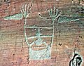
Beginning in 1967, an extensive study of the petroglyphs was begun by French archaeologist Henry de Lumley. De Lumley and a team of his postgraduate students classified the petroglyphs in the 40 km² area, with the greatest concentration in a 14 km² archaeological site on the slope of Mount Bégo. the engravings display objects like daggers, axes, and scythes. Suns, stars and spirals are represented. Ovals with criss-crossed lines may represent land or the earth. Some anthropomorphic figures have been found. The most common drawings are of horned animals.[2]
Henry de Lumley has theorized the petroglyphs are the work of a Mediterranean Bronze Age people who worshipped the bull and for whom Mount Bégo was a sacred site.[3]
The Musée des Merveilles at Tende houses numerous castings of the petroglyphs.
"The rock with one burst"

A plough, two animals and a man
The chief of the tribe
Le Sorcier

Le Christ

Petroglyphs


References[]
- ^ Bauer, Francoise (2002). "The European Diploma of Protected Areas" (PDF). Parks. The World Conservation Union. 12 (3). Retrieved 23 September 2011.
- ^ Lieberman, Marcia (5 April 1992). "Hiking a Valley of Marvels in France". New York Times. Retrieved 23 September 2011.
- ^ Hughes, Stella (7 February 1997). "Cave cult stirs passions of pre-historians". Times Higher Education.
External links[]
| Wikimedia Commons has media related to Vallée des Merveilles. |
- (in English) Mount Bego prehistoric rock carvings by Nicoletta Bianchi
- (in English) Official site of marvels museum from Tende
- (in French) Entretien avec la directrice du Musée des Merveilles
- Base Mérimée: Gravures rupestres de la vallée des Merveilles et de la région du Mont Bégo, Ministère français de la Culture. (in French)
- (in French) Stèle pour stèle dans la Vallée des Merveilles film by Robert Field, 1989, 12 minutes. Production SFRS/CERIMES.
- (in French) La Vallée des merveilles - Les gravures rupestres de l'âge du bronze film by Henry de Lumley, 1971, 21 minutes. Production SFRS/CERIMES.
Coordinates: 44°4′34″N 7°26′18″E / 44.07611°N 7.43833°E

| hide Authority control | |
|---|---|
| General |
|
| National libraries | |
- Landforms of Alpes-Maritimes
- Mercantour National Park
- Rock art in France
- Petroglyphs
- Landforms of Provence-Alpes-Côte d'Azur
- Valleys of France
- Bronze Age France
- Archaeology of Provence-Alpes-Côte d'Azur