Vietnamese Demilitarized Zone

The Vietnamese Demilitarized Zone was a demilitarized zone established as a dividing line between North and South Vietnam from July 1954 to 1976 as a result of the First Indochina War. During the Vietnam War (1955-1975) it became important as the battleground demarcation separating North from South Vietnamese territories. The zone ceased to exist with the reunification of Vietnam on 2 July 1976, though the area remains dangerous due to the numerous undetonated explosives it contains.
Geography[]

The border between North and South Vietnam was 76.1 kilometers (47.3 mi) in length and ran from east to west near the centre of present-day Vietnam within Quảng Trị Province.[1] Beginning in the west at the tripoint with Laos, it ran east in a straight line until reaching the village of Bo Ho Su on the Bến Hải River. The line then followed this river as it flowed in a broadly north-eastwards direction out to the Gulf of Tonkin. Either side of the line was a Demilitarized Zone, forming a buffer of about 6.4–9.7 kilometers (4–6 mi) in width.[1] Although it was nominally described as being at "the 17th parallel," the border never actually followed that line, only straddling the general area of that line of latitude.
History[]

The First Indochina War (also called the French Indochina War) was fought in French Indochina from 1946 to 1954 between France and the French-controlled State of Vietnam on the one side, and the Communist-dominated independence movement the Viet Minh (aided by China and the USSR) on the other.[1] The Viet Minh won the war, gaining effective control of all northern Vietnam except an enclave around Hanoi. On 21 July 1954, the Republic of France gave up its control of Vietnam, and the Democratic Republic of Vietnam was recognized as the government of northern Vietnam by France while "recognizing" the State of Vietnam as the government of southern Vietnam at the same time.[1]
The post-colonial conditions of Vietnam were set at the Geneva Conference of 1954 and an agreement was finalized on July 21, 1954.[1] The agreement reflected the military situation on the ground: the northern part of Vietnam, which was almost entirely controlled by the Viet Minh, became the Democratic Republic of Vietnam, under Communist leader Ho Chi Minh, whilst the southern part of Vietnam, where the Viet Minh controlled only relatively small and remote areas, became the independent State of Vietnam under Bảo Đại, the last scion of the old Vietnamese imperial house. The State of Vietnam later became the Republic of Vietnam. A temporary boundary running primarily along the Bến Hải River was established pending elections, with the area on either side of the border declared a demilitarized zone - troops of both governments were barred from this area.[2]
War between North and South broke out in 1950s and the DMZ hardened into a de facto international boundary, with the war evolving into a proxy conflict of the Cold War and thousands of American troops being sent to the country. Despite the DMZ's supposed status, 3rd Marine Division intelligence estimated that the combat strength of NVA and Viet Cong forces in the DMZ area in January 1968 was 40,943 troops.[3] The north was ultimately victorious in the war in 1975, and the DMZ ceased to exist following the reunification of Vietnam on 2 July 1976.
Tourism[]
Exploring the Demilitarized Zone can today be comfortably achieved by joining one of various tours starting daily from Huế or Đà Nẵng.[4] Together with a local guide the most famous war settings, such as Khe Sanh Combat Base, The Rockpile, Ho Chi Minh Trail, Doc-Mieu-Station or the Vinh Moc tunnels, are visited on a full-day trip.
Although the Vietnam War ended decades ago, walking outside marked tracks can still be dangerous because of numerous unexploded ordnance devices.[5]
Gallery[]
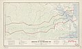
Map of the DMZ from 1957
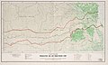
Map of the DMZ from 1966


See also[]
- 1st Searchlight Battery (United States)
- Clear Path International - an American NGO assisting victims of bombs and landmines left over from the Vietnam War in Central Vietnam
- Demilitarized zone
- Hien Luong Bridge
- Korean Demilitarized Zone
- McNamara Line
- Inner German border and Berlin Wall
References[]
- ^ Jump up to: a b c d e "International Boundary Study No. 19 – Vietnam – "Demarcation Line"" (PDF). US Department of State. Retrieved 21 September 2020.
- ^ "17th parallel". Encyclopedia Britannica. Retrieved 21 September 2020.
- ^ Pike, COL Thomas F., Military Records, February 1968, 3rd Marine Division: The Tet Offensive, p. 115, ISBN 978-1-481219-46-4. NVA and VC Order of Battle information is located on pages 114-127
- ^ "DMZ Vietnam Travel". Vietnam Guide. Retrieved 21 September 2020.
- ^ Lonely Planet, ISBN 978-3-8297-1595-9.
External links[]
| Wikivoyage has a travel guide for DMZ (Vietnam). |
- Archive.org: Blurry Travel Guide to the DMZ — with photos.
- Honan.ne: Photos of DMZ
- Washington Post map of the DMZ
Coordinates: 16°54′N 107°00′E / 16.9°N 107.0°E

| show Authority control |
|---|
- North Vietnam
- South Vietnam
- Borders of Vietnam
- International borders
- Demilitarized zones
- North Central Coast
- Quảng Bình Province
- Quảng Trị Province
- First Indochina War
- Vietnam War sites
- 1950s in Vietnam
- 1960s in Vietnam
- 1970s in Vietnam
- 1954 establishments in Vietnam
- 1975 disestablishments in Vietnam
- Regions of Vietnam