Villa Santa Lucia degli Abruzzi
Villa Santa Lucia degli Abruzzi | |
|---|---|
| Comune di Villa Santa Lucia degli Abruzzi | |
 | |
 Coat of arms | |
Location of Villa Santa Lucia degli Abruzzi  | |
 Villa Santa Lucia degli Abruzzi Location of Villa Santa Lucia degli Abruzzi in Italy | |
| Coordinates: 42°20′3″N 13°46′40″E / 42.33417°N 13.77778°E | |
| Country | Italy |
| Region | Abruzzo |
| Province | L'Aquila (AQ) |
| Frazioni | Carrufo,Randino. |
| Government | |
| • Mayor | Paride Ciotti |
| Area | |
| • Total | 27.84 km2 (10.75 sq mi) |
| Elevation | 900 m (3,000 ft) |
| Population (1 January 2007)[3] | |
| • Total | 174 |
| • Density | 6.3/km2 (16/sq mi) |
| Demonym(s) | Villesi |
| Time zone | UTC+1 (CET) |
| • Summer (DST) | UTC+2 (CEST) |
| Postal code | 67020 |
| Dialing code | 0862 |
| Patron saint | St. Lucy |
| Saint day | 13 December |


Villa Santa Lucia degli Abruzzi is a little comune and town in the province of L'Aquila in the Abruzzo region of Italy. It is located in the Gran Sasso e Monti della Laga National Park.
Twin town[]
 Port Colborne, Canada
References[]
- ^ "Superficie di Comuni Province e Regioni italiane al 9 ottobre 2011". Italian National Institute of Statistics. Retrieved 16 March 2019.
- ^ "Popolazione Residente al 1° Gennaio 2018". Italian National Institute of Statistics. Retrieved 16 March 2019.
- ^ All demographics and other statistics from the Italian statistical institute (Istat)
External links[]
Gallery[]
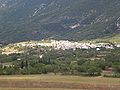
Panorama of V.S.L.dA.

Cats of Carrufo
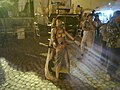
Dancing of the pupa 1

Dancing of the pupa 2

Dancing of the pupa 3


This Abruzzo location article is a stub. You can help Wikipedia by . |
Categories:
- Cities and towns in Abruzzo
- Municipalities of the Province of L'Aquila
- Abruzzo geography stubs