Villamaría, Caldas
Villamaría, Caldas | |
|---|---|
Municipality and town | |
 | |
 Flag  Seal | |
 Location of the municipality and town of Villamaría, Caldas in the Caldas Department of Colombia. | |
 Villamaría, Caldas Location in Colombia | |
| Coordinates: 5°05′52″N 75°30′56″W / 5.09778°N 75.51556°W | |
| Country | |
| Department | |
| Founded | October 19, 1852 |
| Government | |
| • Mayor | Juan Alejandro Holguin |
| Area | |
| • Municipality and town | 461 km2 (178 sq mi) |
| • Metro | 50,956 km2 (19,674 sq mi) |
| Elevation | 1,920 m (6,300 ft) |
| Population (2012) | |
| • Municipality and town | 43,085 |
| • Density | 93/km2 (240/sq mi) |
| Demonym(s) | Villamariano |
| Time zone | UTC-5 (Colombia Standard Time) |
| Area code(s) | 57 + 6 |
| Website | Official website (in Spanish) |

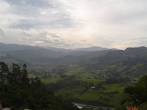
Villamaría is a town and municipality in the Colombian Department of Caldas. Located in the Colombian coffee growing axis, it was made part of the "Coffee Cultural Landscape" UNESCO World Heritage Site in 2011.[1]
Climate[]
The city of Villamaría and the lower parts of the municipality have a subtropical highland climate (Köppen Cfb).
| hideClimate data for Villamaría | |||||||||||||
|---|---|---|---|---|---|---|---|---|---|---|---|---|---|
| Month | Jan | Feb | Mar | Apr | May | Jun | Jul | Aug | Sep | Oct | Nov | Dec | Year |
| Average high °C (°F) | 22.8 (73.0) |
22.8 (73.0) |
22.7 (72.9) |
22.0 (71.6) |
22.0 (71.6) |
21.8 (71.2) |
22.7 (72.9) |
22.5 (72.5) |
22.1 (71.8) |
21.3 (70.3) |
21.4 (70.5) |
22.0 (71.6) |
22.2 (71.9) |
| Daily mean °C (°F) | 17.7 (63.9) |
17.8 (64.0) |
18.1 (64.6) |
17.7 (63.9) |
17.9 (64.2) |
17.5 (63.5) |
17.8 (64.0) |
17.8 (64.0) |
17.4 (63.3) |
17.0 (62.6) |
17.0 (62.6) |
17.3 (63.1) |
17.6 (63.6) |
| Average low °C (°F) | 12.6 (54.7) |
12.9 (55.2) |
13.5 (56.3) |
13.4 (56.1) |
13.8 (56.8) |
13.3 (55.9) |
12.9 (55.2) |
13.1 (55.6) |
12.8 (55.0) |
12.8 (55.0) |
12.7 (54.9) |
12.7 (54.9) |
13.0 (55.5) |
| Average rainfall mm (inches) | 110.4 (4.35) |
116.5 (4.59) |
160.5 (6.32) |
213.9 (8.42) |
224.8 (8.85) |
154.1 (6.07) |
98.3 (3.87) |
95.5 (3.76) |
159.1 (6.26) |
249.8 (9.83) |
232.8 (9.17) |
138.5 (5.45) |
1,954.2 (76.94) |
| Average rainy days (≥ 1 mm) | 11 | 12 | 16 | 20 | 20 | 17 | 12 | 11 | 16 | 20 | 19 | 12 | 186 |
| Source 1: [2] | |||||||||||||
| Source 2: [3] | |||||||||||||
While the higher parts of the municipality have an alpine tundra climate (ETH) and the highest part has an ice cap climate (EFH).
| hideClimate data for Las Brisas | |||||||||||||
|---|---|---|---|---|---|---|---|---|---|---|---|---|---|
| Month | Jan | Feb | Mar | Apr | May | Jun | Jul | Aug | Sep | Oct | Nov | Dec | Year |
| Average high °C (°F) | 8.6 (47.5) |
8.5 (47.3) |
8.7 (47.7) |
8.5 (47.3) |
8.5 (47.3) |
8.7 (47.7) |
8.6 (47.5) |
8.6 (47.5) |
8.3 (46.9) |
7.7 (45.9) |
8.0 (46.4) |
8.4 (47.1) |
8.4 (47.2) |
| Daily mean °C (°F) | 4.4 (39.9) |
4.6 (40.3) |
4.8 (40.6) |
5.0 (41.0) |
5.1 (41.2) |
4.9 (40.8) |
4.5 (40.1) |
4.5 (40.1) |
4.4 (39.9) |
4.4 (39.9) |
4.4 (39.9) |
4.5 (40.1) |
4.6 (40.3) |
| Average low °C (°F) | 0.8 (33.4) |
1.0 (33.8) |
1.2 (34.2) |
1.8 (35.2) |
1.9 (35.4) |
1.5 (34.7) |
0.9 (33.6) |
0.9 (33.6) |
1.0 (33.8) |
1.3 (34.3) |
1.5 (34.7) |
1.0 (33.8) |
1.2 (34.2) |
| Average rainfall mm (inches) | 85.7 (3.37) |
83.3 (3.28) |
116.7 (4.59) |
178.0 (7.01) |
189.3 (7.45) |
112.3 (4.42) |
70.7 (2.78) |
73.2 (2.88) |
114.7 (4.52) |
192.2 (7.57) |
145.7 (5.74) |
86.7 (3.41) |
1,448.5 (57.02) |
| Average rainy days (≥ 1 mm) | 14 | 16 | 20 | 23 | 23 | 21 | 18 | 18 | 19 | 25 | 23 | 18 | 238 |
| Average relative humidity (%) | 89 | 92 | 92 | 94 | 93 | 92 | 91 | 91 | 92 | 93 | 92 | 90 | 92 |
| Mean monthly sunshine hours | 96.1 | 84.7 | 71.3 | 45.0 | 52.7 | 72.0 | 102.3 | 99.2 | 63.0 | 43.4 | 63.0 | 83.7 | 876.4 |
| Mean daily sunshine hours | 3.1 | 3.0 | 2.3 | 1.5 | 1.7 | 2.4 | 3.3 | 3.2 | 2.1 | 1.4 | 2.1 | 2.7 | 2.4 |
| Source: [2] | |||||||||||||
References[]
- ^ "Coffee Cultural Landscape". UNESCO World Heritage List. United Nations Educational, Scientific, and Cultural Organization. Retrieved 25 Apr 2011.
- ^ Jump up to: a b http://www.ideam.gov.co/documents/21021/553571/Promedios+Climatol%C3%B3gicos++1981+-+2010.xlsx/f28d0b07-1208-4a46-8ccf-bddd70fb4128
- ^ https://en.climate-data.org/south-america/colombia/caldas/villamaria-47853/
| hide | |||||||||||||
|---|---|---|---|---|---|---|---|---|---|---|---|---|---|
Capital: Manizales | |||||||||||||
| Districts and municipalities |
| ||||||||||||
| show Authority control |
|---|
Coordinates: 5°00′N 75°30′W / 5.000°N 75.500°W
This Caldas Department location article is a stub. You can help Wikipedia by . |
Categories:
- Municipalities of Caldas Department
- Andean Region (Colombia) geography stubs