Virginstow
From Wikipedia, the free encyclopedia
Human settlement in England
| Virginstow | |
|---|---|
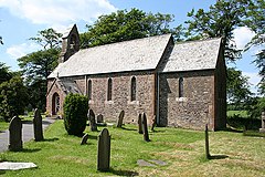
 St Bridget the Virgin | |
 Virginstow Location within Devon | |
| OS grid reference |  SX3882993332 SX3882993332 |
| Shire county |
|
| Region |
|
| Country | England |
| Sovereign state | United Kingdom |
| Post town | Beaworthy |
| Postcode district | EX21 |
| Police | Devon and Cornwall |
| Fire | Devon and Somerset |
| Ambulance | South Western |
| UK Parliament | |
 50°43′00″N 4°17′00″W / 50.716667°N 4.283333°W / 50.716667; -4.283333Coordinates: 50°43′00″N 4°17′00″W / 50.716667°N 4.283333°W / 50.716667; -4.283333Coordinates:  50°43′00″N 4°17′00″W / 50.716667°N 4.283333°W / 50.716667; -4.283333 50°43′00″N 4°17′00″W / 50.716667°N 4.283333°W / 50.716667; -4.283333 | |
Virginstow is a village and civil parish in the Torridge district of Devon, England.[1] It is situated about 7 miles north of Launceston in Cornwall. According to the 2001 census it had a population of 115.
References[]
- ^ Ordnance Survey: Landranger map sheet 190 Bude & Clovelly (Boscastle & Holsworthy) (Map). Ordnance Survey. 2014. ISBN 9780319231456.
External links[]
![]() Media related to Virginstow at Wikimedia Commons
Media related to Virginstow at Wikimedia Commons
Towns, villages and hamlets in the Torridge District of Devon, England | ||
|---|---|---|
 |
| |
| |
|---|---|
| Exeter1,2 |
|
| East Devon1 |
|
| Mid Devon1 |
|
| North Devon1 |
|
| Torridge1 |
|
| West Devon1,3 |
|
| South Hams1 |
|
| Teignbridge1 |
|
| Plymouth2,4 |
|
| Torbay4 |
|
Bold text denotes a parish council referred to as a "town council".
| |
This Devon location article is a stub. You can help Wikipedia by . |
- v
- t
Retrieved from ""
Categories:
- Civil parishes in Devon
- Villages in Devon
- Torridge District
- Devon geography stubs
Hidden categories:
- Use dmy dates from September 2019
- Articles with short description
- Short description is different from Wikidata
- Articles with OS grid coordinates
- Coordinates on Wikidata
- Commons category link is on Wikidata
- AC with 0 elements
- All stub articles