Visakhapatnam geography and environment

It has been suggested that this article be merged into Visakhapatnam. (Discuss) Proposed since November 2021. |
Visakhapatnam is located in Andhra Pradesh state in southeastern India. The city's area is 682 km2. It is located at 17°42′15″N 83°17′52″E / 17.70417°N 83.29778°E. The average elevation is 45 metres.[1] Visakhpatnam is situated in Coastal Andhra Region.[2]
 WikiMiniAtlas
Geography[]
Visakhapatnam is mainly situated between the Eastern Ghats mountain range and the Bay of Bengal. The city is surrounded by the Simhachalam Hill Range to the west, the Yarada Hills to the southeast, and Kambalakonda Wildlife Sanctuary to the northwest. The hills play an important role in Visakhapatnam's ecological environment and cover over 621.52 km2.[3]
Climate[]
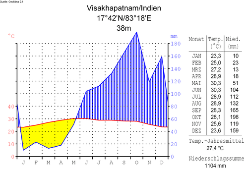
Visakhapatnam's climate is generally a tropical savanna climate under the Köppen Aw classification. The average annual temperature is 26.9 °C (80.4 °F). Annual rainfall is 1,071 mm (42.2 in).[4]
Hills in Visakhapatnam[]
- Eastern Ghats
- Simhachalam Hills
- Yarada Hills
- Erra Matti Dibbalu
- Dolphin's Nose Hills
- Kailasagiri Hills
See also[]
References[]
- ^ "introduction". USA: britannica. Retrieved 24 October 2016.
- ^ "situated place". India: andhrauniversity. Retrieved 21 May 2013.
- ^ "unauthorised hill slope occupation an environmental hazard". India: times of india. Retrieved 21 March 2016.
- ^ "climate of the city". India: climate data. Retrieved 16 July 2020.

- Geography of Visakhapatnam
- Geography of Andhra Pradesh