Vries Strait
Vries Strait (пр.Фриза)
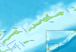
Vries Strait or Miyabe Line is a strait between two main islands of the Kurils. It is located between the northeastern end of the island of Iturup and the southwestern headland of Urup Island, connecting the Sea of Okhotsk on the west with the Pacific Ocean on the east. It has a width of 42 km.
The strait is named after Dutch explorer Maarten Gerritsz Vries, the first recorded European to explore the area in 1643.[1]
References[]
- ^ "THE 17TH AND 18TH CENTURIES". Archived from the original on 2008-03-25. Retrieved 2012-01-16.
Coordinates: 45°30′20″N 149°10′36″E / 45.50556°N 149.17667°E

This Sakhalin Oblast location article is a stub. You can help Wikipedia by . |
Categories:
- Straits of the Kuril Islands
- Maritime history of the Dutch East India Company
- Sakhalin Oblast geography stubs