Vyzhnytsia
Vyzhnytsia
Вижниця | |
|---|---|
Town | |
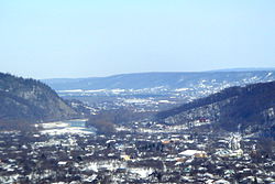 View of the town | |
|
Flag  Coat of arms | |
 Vyzhnytsia Location within Ukraine | |
| Coordinates: 48°15′0″N 25°11′30″E / 48.25000°N 25.19167°E | |
| Country | Ukraine |
| Oblast | Chernivtsi Oblast |
| District | Vyzhnytsia Raion |
| Founded | 1158 |
| Government | |
| • Mayor | Alex G. Chepil |
| Area | |
| • Land | 9 km2 (3 sq mi) |
| Elevation | 356 m (1,168 ft) |
| Population (2021) | |
| • Total | 3,875 |
| Zip Code | 59200 |
| Area code(s) | +380-3730 |
| Website | vnmiscrada |


Vyzhnytsia (/ˈvɪʒnɪts(j)ə/; Ukrainian: Ви́жниця [ˈwɪʒnɪtsʲɐ]; German: Wischnitz; Polish: Wyżnica; Romanian: Vijnița; Russian: Вижница, romanized: Vizhnitsa; Yiddish: וויזשניץ, romanized: Vizhnitz) is a town located in the historical region of Bukovina, on the Cheremosh River in Chernivtsi Oblast of western Ukraine. It is the administrative center of Vyzhnytsia Raion. Vyzhnytsia hosts the administration of , one of the hromadas of Ukraine.[1] Population: 3,875 (2021 est.)[2]
History[]
Part of the Austro-Hungarian Empire[]
In Judaism, the town is known as having been the original center of the Hassidic sect bearing its Yiddish name (וויזשניץ Vizhnitz). The town's Jewish community was decimated in the Holocaust and most survivors did not return, but the flourishing Vizhnitz Hassidic community in Israel and elsewhere continues to keep the name.
Until World War I, the town was named Wischnitz and was part of Austria-Hungary.

Part of Soviet Ukraine[]
Vyzhnytsa has been a city since 1940.[3] A local newspaper has been published in the city since February 1945.[4]
In the late 1960s and early 1970s, Vyzhnytsa was the center of a flourishing Ukrainian-language music scene that was renowned all over the Soviet Union. The local house of culture was renowned for its parties with illegal Western pop music and attracted young people from as far as Chernivtsi.[5] Volodymyr Ivasyuk was named as a regular visitor of these parties. There, he befriended musician .[6] Dutkivskiy from there on founded VIA , with later Nazariy Yaremchuk and Vasyl Zinkevych as lead singers. Smerichka became one of Ukraine's most famous groups at the time, performing at Pesnya goda twice and winning Allo, my ishchem talanty! (Hello, we are looking for talents!) in 1972, one of the first Soviet television talent shows.[7]
Part of modern Ukraine[]
In January 1989 the population was 5708 people.[8][3]
In 2011 a security checkpoint "Vyzhnytsia" was built here.[9]
In January 2013 the population was 4207 people.[10]
Transport[]
- a railway station[3] of the Lviv Railways.
Notable people[]
- Josef Burg, writer
- Gerard Ciołek, architect
- Menachem Mendel Hager, first Vizhnitser Rebbe
- Nazariy Yaremchuk, singer
- Otto Preminger, director
- Dol Dauber, musician
- Meir Just, Dutch rabbi
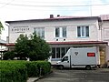
Gallery[]

St Michael's Church

St Peter and Paul Catholic Church

St Demetrius Church
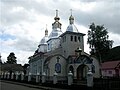
Holy Trinity Church

City Hall

Old city of Vyzhnytsia

Children's art house
Vyzhnytsia cinema


Nearby towns[]
- Kuty
- Kosiv
References[]
- ^ "Вижницкая городская громада" (in Russian). Портал об'єднаних громад України.
- ^ "Чисельність наявного населення України (Actual population of Ukraine)" (PDF) (in Ukrainian). State Statistics Service of Ukraine. Retrieved 11 July 2021.
- ^ Jump up to: a b c Вижница // Большой энциклопедический словарь (в 2-х тт.). / редколл., гл. ред. А. М. Прохоров. том 1. М., "Советская энциклопедия", 1991. стр.218
- ^ № 3265. Советская Верховина // Летопись периодических и продолжающихся изданий СССР 1986 – 1990. Часть 2. Газеты. М., "Книжная палата", 1994. стр.426
- ^ Feshchuk, Nataliya (27 December 2006). ""заслушавшись выступлением ансамбля "смерiчка" в прямом эфире, руководство центрального телевидения ссср на 15 минут задержало программу "время"". Fakty.ua. Retrieved 9 February 2021.
- ^ Feshchuk, Nataliya. ""Івасюк зізнався, що стиль "Смерічки" його захопив"". Zbruc. Retrieved 9 February 2021.
- ^ Etushenko, Aleksandr. ""Смерічка" и "Золота колекція"". Den'. Retrieved 9 February 2021.
- ^ "Демоскоп Weekly - Приложение. Справочник статистических показателей". www.demoscope.ru.
- ^ Где в Украине расположены стационарные посты ДПС ГАИ // еженедельник "2000" от 7 мая 2012
- ^ "Чисельність наявного населення України на 1 січня 2013 року. Державна служба статистики України. ��иїв, 2013. стор.108" (PDF).
Coordinates: 48°15′N 25°11.5′E / 48.250°N 25.1917°E
| show Authority control |
|---|
- Bukovina
- Cities in Chernivtsi Oblast
- Shtetls
- Vizhnitz (Hasidic dynasty)
- Cities of district significance in Ukraine
- Duchy of Bukovina
- Holocaust locations in Ukraine